METAR & TAF KSGJ
Current METAR
Observed 05:56Z
KSGJ 260556Z AUTO 25004KT 10SM CLR 26/24 A3000 RMK AO2 SLP158 6//// T02560239 10289 20256 56018 PNO $
- Wind
- 250° @ 4 kt
- Visibility
- 10 SM
- Temp / Dew
- 26°C / 24°C
- Altimeter
- 30.00 inHg
- Clouds
- CLR
- Density alt
- 1,233 ft
- Ceiling
- Unlimited
- Rules
- VFR
Airport info & contacts
Manager on record, flight service, ARTCC, attendance schedule and pattern altitude — published by the FAA and refreshed every 28 days.
Location
- From city
- 4 NM N
- VFR sectional
- JACKSONVILLE
- ARTCC
- ZJX · JACKSONVILLE
- NOTAM facility
- SGJ (NOTAM-D)
Airport manager
- Name
- COURTNEY PITTMAN
- Phone
- 904-209-0090
- Address
- 4796 US 1 NORTH, ST AUGUSTINE FL 32095
Flight service · Hours
- FSS GNV
- GAINESVILLE1-800-WX-BRIEF
- Attendance
- 0600-2200
Frequencies
Tap any row to copy the frequency to your clipboard.
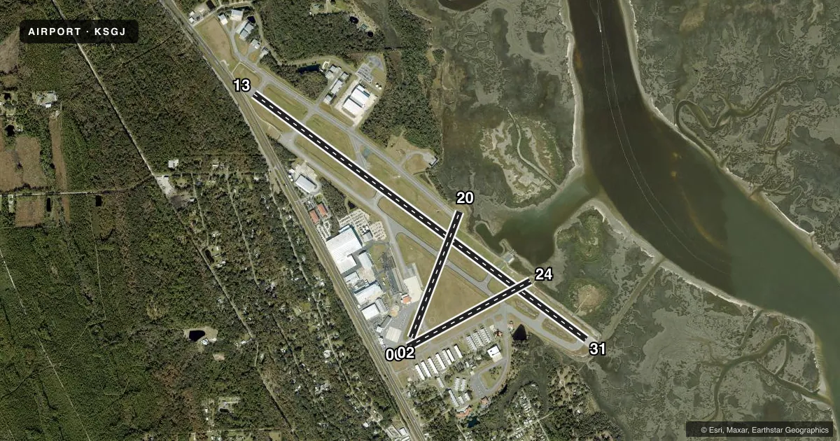
Runways & pattern
Full pagePattern entry · RWY 24
LEFT TRAFFIC| Runway | Heading (°M) | Length | Surface | Traffic |
|---|---|---|---|---|
| 13/31 | 122° / 302° | 8,001 ft | ASPH | Standard L |
| 06/24Favored | 58° / 238° | 2,701 ft | ASPH | Standard L |
| 02/20 | 17° / 197° | 2,609 ft | ASPH | Standard L |
Runway end performance
| End | TORA | TODA | ASDA | LDA | VGSI | Approach lights | Obstruction |
|---|---|---|---|---|---|---|---|
| 13 | 8,001' | 8,001' | 7,202' | 6,144' | VASI 4-box left(3°) | — | 15', road, 200' from thr, 150' R of cntrln, slope 0 |
| 31 | 8,001' | 8,001' | 6,730' | 5,925' | PAPI 4-box left(3°) | MALSR | — |
| 06 | 2,701' | 2,701' | 2,701' | 2,701' | PAPI 2-box left(3.25°) | — | 53', trees, 1055' from thr, 145' R of cntrln, slope 16 |
| 24 | 2,701' | 2,701' | 2,701' | 2,701' | — | — | — |
| 02 | 2,610' | 2,610' | 2,610' | 2,610' | — | — | 76', trees, 1345' from thr, 75' R of cntrln, slope 15 |
| 20 | 2,610' | 2,610' | 2,610' | 2,610' | — | — | — |
Declared distances in feet. TORA = takeoff run available, TODA = takeoff distance, ASDA = accelerate-stop, LDA = landing distance.
Airport sketch
Runways drawn to scale from FAA survey coordinates, rendered over satellite imagery. Not for navigation.
Approaches & charts
ILS · 1
Services on the field
Fuel grades, oxygen, maintenance, ramp storage and lighting — as declared to the FAA by the airport operator.
Fuel & services
- Fuel
- 100LLA
- Oxygen (bottled)
- HIGH/LOW
- Oxygen (bulk)
- Not available
- Airframe repair
- Major
- Power plant repair
- Major
- Other services
- AMB,AVNCS,CHTR,INSTR,RNTL,SALES
Ramp & ground
- Transient storage
- Tie-down
- Hangar
- Landing fee
- No fee published
- Customs
- Not available
- Lighting schedule
- SEE RMK
- Beacon schedule
- SS-SR
- Beacon
- White / Green (civil land)(WG)
- Wind indicator
- Lighted
- Segmented circle
- Yes
Fuel & FBOs
Cheapest 100LL and Jet A on the field and nearby. Always confirm with the FBO before taxi.
Airport notes
Surface conditions, obstructions, local procedures, lighting outages and other notes published with each FAA cycle.
General notes
- AEROBATIC ACT E SIDE OF RWY 13/31 CTC TWR FOR TFC & GNV RADIO FOR TIMES.
- FICON NOT MNTD 2100 - 0700 LCL.
- FOR CD IF UNA TO CTC ON FSS FREQ, CTC JACKSONVILLE APCH AT 904-741-0284.
Lighting notes
- ACTVT MALSR RWY 31; HIRL RWY 13/31; MIRL RWY 06/24 & 2/20 - CTAF. PAPI RWY 06 & 31 AND VASI RWY 13 OPR CONSLY.
Fuel notes
- 100LLJET SINGLE POINT REFUELING AVBL.
- ASELF SVC FUEL AVBL 24 HRS WITH CREDIT CARD.
Runway surface & condition
- 02/20PCR VALUE: 30/F/A/X/T
- 06/24PCR VALUE: 30/F/A/X/T
- 13/31PCR VALUE: 790/F/A/X/T
- 02/20RWY 02/20 NOT AVBL FOR PART 121/PART 380 OPS WITH SKED PAX CARRYING OPS MORE THAN 9 PAX SEATS AND NON-SKED PAX CARRYING OPS MORE THAN 30 PAX SEATS.
- 06/24RWY 06/24 NOT AVBL FOR PART 121/PART 380 OPS WITH SKED PAX CARRYING OPS MORE THAN 9 PAX SEATS AND NON-SKED PAX CARRYING OPS MORE THAN 30 PAX SEATS.
- 12W/30WRWY 12W/30W NOT AVBL FOR PART 121/PART 380 OPS WITH SKED PAX CARRYING OPS MORE THAN 9 PAX SEATS AND NON-SKED PAX CARRYING OPS MORE THAN 30 PAX SEATS.
- 17W/35WRWY 17W/35W NOT AVBL FOR PART 121/PART 380 OPS WITH SKED PAX CARRYING OPS MORE THAN 9 PAX SEATS AND NON-SKED PAX CARRYING OPS MORE THAN 30 PAX SEATS.
- 18W/36WRWY 18W/36W NOT AVBL FOR PART 121/PART 380 OPS WITH SKED PAX CARRYING OPS MORE THAN 9 PAX SEATS AND NON-SKED PAX CARRYING OPS MORE THAN 30 PAX SEATS.
Approach & departure obstructions
- 13ROAD 15 FT TALL 200 FT BFR AER OF RWY 13 150 RIGHT OF CNTRLN.
- 13RWY 13 APCH SLP 34:1 TO MKD DSPCD THR.
Other notes
- PPR 24 HRS FOR UNSKED ACR OPS WITH MORE THAN 30 PAX SEATS CALL AMGR 904-209-0090.
- INTL LRA. USER FEE CTC U.S.CUSTOMS ON ARPT 904-209-0099.
VFR map & nearby airports
VFR sectional. Tap any ICAO chip to open that airport.
Key facts · KSGJ
Answer card- ICAO
- KSGJ
- Name
- ST AUGUSTINE
- Location
- ST AUGUSTINE, FLORIDA
- Elevation
- 9.8 ft MSL
- Traffic pattern altitude
- 1,009.8 ft MSL (1,000 AGL)
- Control tower
- Towered · 0700-2100
- Total runways
- 3
- Longest runway
- 13/31 · 8,001 ft
- Published ILS approaches
- 1
- Published frequencies
- 8
- Magnetic variation
- 4°
- Current flight rules
- VFR
- Current wind
- 250° at 4 kt
- Favored runway now
- RWY 24
St Augustine Airport sits in St Augustine, Florida. Field elevation is 9.8 ft MSL. The airport has three asphalt runways. The longest is runway 13/31 at 8,001 ft. The tower is open daily from 0700 to 2100 local. One ILS is published for runway 31. Pattern altitude is not published, so use the standard 1,000 ft AGL for light piston unless ATC gives you something different.
On the field, Atlantic Aviation carries 100LL and Jet A. St. Augustine Airport also carries 100LL. The field is an international landing rights airport. Contact U.S. Customs on the airport for user fees and arrival details. The published remarks also note aerobatic activity on the east side of runway 13/31. That is worth keeping in mind if you are inbound or working the pattern.
Runway 13 has a road obstruction about 200 ft before the aerodrome and 150 ft right of centerline. Runway 31 has MALSR and high intensity lighting. Runways 06 and 31 have continuous PAPI. Runway 13 has continuous VASI. The field condition is not maintained from 2100 to 0700 local time. For a first arrival, pay attention to the tower hours. Pay attention to the runway lighting setup. Pay attention to the active aerobatic area. If you need clearance delivery and cannot reach Flight Service, Jacksonville Approach is listed as the backup contact.