METAR & TAF KCWV
Current METAR
Observed 12:55Z
KCWV 271255Z AUTO 25003KT 7SM BR CLR 25/25 A2988 RMK AO2
- Wind
- 250° @ 3 kt
- Visibility
- 7 SM
- Temp / Dew
- 25°C / 25°C
- Altimeter
- 29.88 inHg
- Clouds
- CLR
- Density alt
- 1,388 ft
- Ceiling
- Unlimited
- Rules
- VFR
Airport info & contacts
Manager on record, flight service, ARTCC, attendance schedule and pattern altitude — published by the FAA and refreshed every 28 days.
Location
- From city
- 3 NM NE
- VFR sectional
- ATLANTA
- ARTCC
- ZJX · JACKSONVILLE
- NOTAM facility
- MCN (NOTAM-D)
Airport manager
- Name
- VERNON OWENS, AIRPORT MANAGER
- Phone
- 912-739-0124
- Address
- 389 AIRPORT ROAD, CLAXTON GA 30417
Flight service · Hours
- FSS MCN
- MACON1-800-WX-BRIEF
- Attendance
- MON-FRI · 0815-1500
Frequencies
Tap any row to copy the frequency to your clipboard.
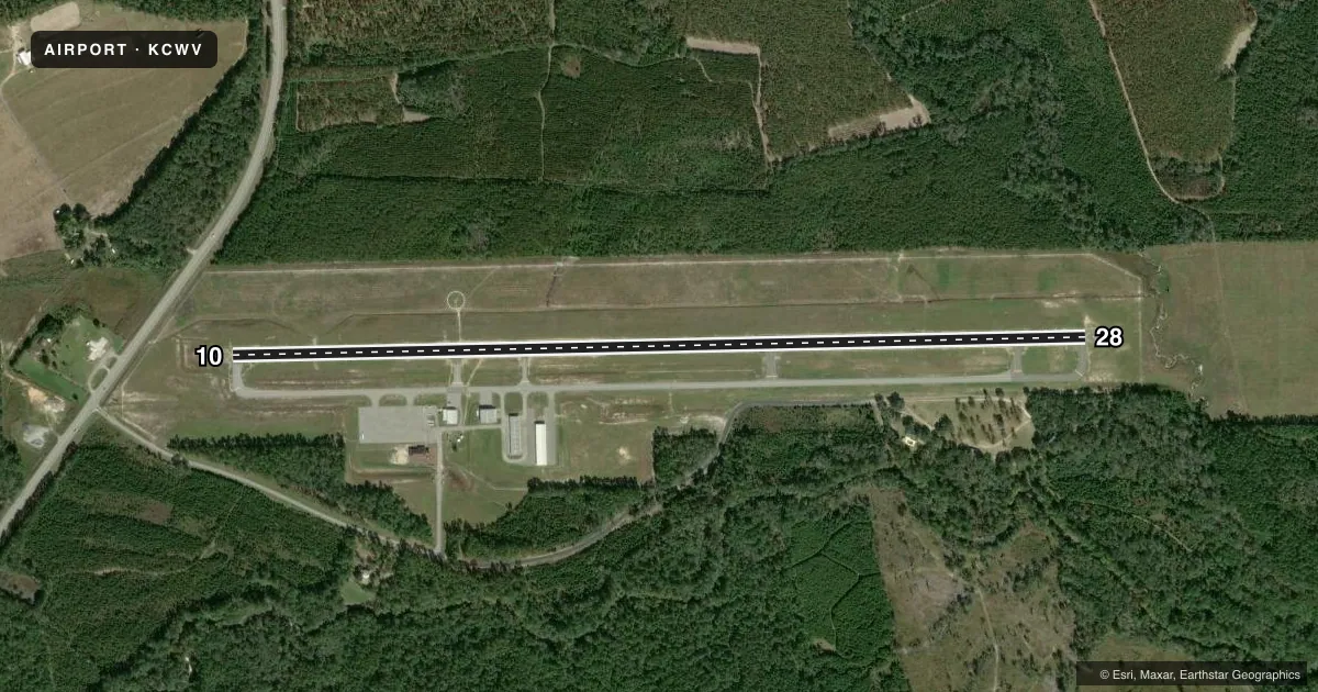
Runways & pattern
Full pagePattern entry · RWY 28
LEFT TRAFFICRunway end performance
| End | TORA | TODA | ASDA | LDA | VGSI | Approach lights | Obstruction |
|---|---|---|---|---|---|---|---|
| 10 | 5,151' | 5,151' | 5,151' | 4,651' | PAPI 2-box left(3°) | — | 18', road, 414' from thr, 282' R of cntrln, slope 11 |
| 28 | 5,151' | 5,151' | 5,151' | 5,151' | PAPI 2-box left(3°) | — | 89', trees, 2514' from thr, 121' R of cntrln, slope 26 |
Declared distances in feet. TORA = takeoff run available, TODA = takeoff distance, ASDA = accelerate-stop, LDA = landing distance.
Airport sketch
Runways drawn to scale from FAA survey coordinates, rendered over satellite imagery. Not for navigation.
Approaches & charts
Services on the field
Fuel grades, oxygen, maintenance, ramp storage and lighting — as declared to the FAA by the airport operator.
Fuel & services
- Fuel
- 100LL
- Oxygen (bottled)
- Not available
- Oxygen (bulk)
- Not available
- Airframe repair
- Not available
- Power plant repair
- Not available
Ramp & ground
- Transient storage
- Tie-down
- Landing fee
- No fee published
- Customs
- Not available
- Lighting schedule
- SEE RMK
- Beacon schedule
- SS-SR
- Beacon
- White / Green (civil land)(WG)
- Wind indicator
- Lighted
- Segmented circle
- Yes
Fuel & FBOs
Cheapest 100LL and Jet A on the field and nearby. Always confirm with the FBO before taxi.
Airport notes
Surface conditions, obstructions, local procedures, lighting outages and other notes published with each FAA cycle.
General notes
- FOR CD CTC JACKSONVILLE ARTCC AT 904-845-1592.
Lighting notes
- ACTVT REIL RWY 10 & 28; PAPI RWYS 10 & 28 - CTAF. MIRL RWY 10/28 PRESET LOW INTST; TO INCR INTST & ACTVT AFTER 2200 - CTAF.
Approach & departure obstructions
- 10RWY 10 - 20:1 SLP TO DSPLCD THLD.
VFR map & nearby airports
VFR sectional. Tap any ICAO chip to open that airport.
Key facts · KCWV
Answer card- ICAO
- KCWV
- Name
- CLAXTON-EVANS COUNTY
- Location
- CLAXTON, GEORGIA
- Elevation
- 111.5 ft MSL
- Traffic pattern altitude
- 1,111.5 ft MSL (1,000 AGL)
- Control tower
- Non-towered (use CTAF)
- Total runways
- 1
- Longest runway
- 10/28 · 5,151 ft
- Published ILS approaches
- 0
- Published frequencies
- 2
- Magnetic variation
- 7°
- Current flight rules
- VFR
- Current wind
- 250° at 3 kt
- Favored runway now
- RWY 28
Claxton-Evans County Airport sits in Claxton, Georgia. The field elevation is 111.5 ft MSL. It has one runway, 10/28, which is 5,151 ft long. There is no control tower, so expect non-towered traffic flow on CTAF 122.8. That is also the UNICOM frequency.
No ILS approaches are published here. Pattern altitude is not published in the facts, so verify the current Chart Supplement before you fly. The on-field FBO is Claxton-Evans County Airport. It carries AVGAS 100LL. Call ahead at (912) 739-0124 if you need current service status.
A published remark notes a 20 to 1 slope to the displaced threshold on Runway 10. That is worth keeping in mind on short final. The lights are pilot-controlled on CTAF. Runway end identifier lights and PAPI are available for both ends. The medium intensity runway lights are preset to low intensity. After 2200, use CTAF to raise intensity and turn them on. For IFR departures, clearance delivery goes through Jacksonville ARTCC at 904-845-1592. First-time pilots should plan for a simple non-towered field with one asphalt runway. Brief the lighting and threshold note before arrival.