METAR & TAF I96
I96 does not publish a METAR.
Showing the nearest reporting station: KAAS (TAYLOR COUNTY) · 16.5 NM away. Conditions at I96 may differ.
METAR · KAAS
Observed 10:15Z
KAAS 271015Z AUTO 00000KT 4SM OVC001 21/21 A2999 RMK AO1
- Wind
- 000° @ 0 kt
- Visibility
- 4 SM
- Temp / Dew
- 21°C / 21°C
- Altimeter
- 29.99 inHg
- Clouds
- OVC
- Density alt
- 1,649 ft
- Ceiling
- 100 ft AGL
- Rules
- LIFR
Airport info & contacts
Manager on record, flight service, ARTCC, attendance schedule and pattern altitude — published by the FAA and refreshed every 28 days.
Location
- From city
- 2 NM SW
- VFR sectional
- ST LOUIS
- ARTCC
- ZID · INDIANAPOLIS
- NOTAM facility
- LOU (NOTAM-D)
Airport manager
- Name
- PERRY PARRISH
- Phone
- (270) 634-0733
- Address
- 735 COUNTRY CLUB ROAD, COLUMBIA KY 42728
Flight service · Hours
- FSS LOU
- LOUISVILLE1-800-WX-BRIEF
- Attendance
- Unattended
Frequencies
Tap any row to copy the frequency to your clipboard.
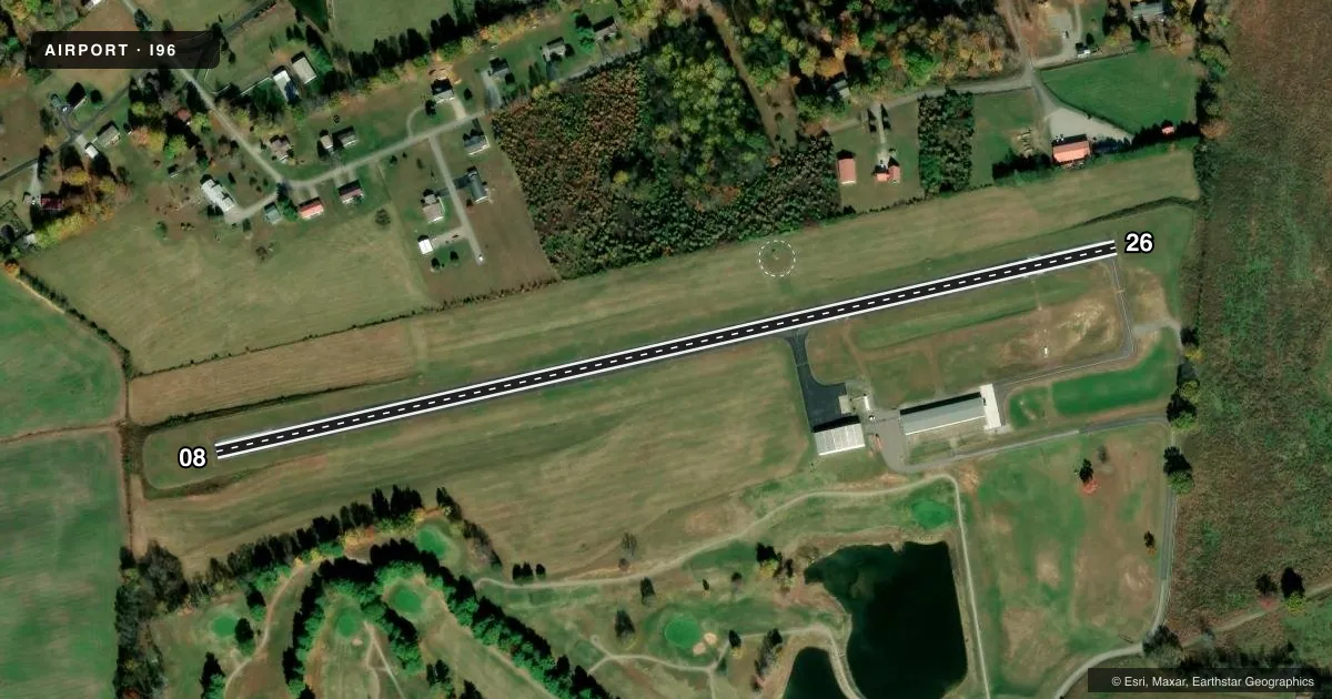
Runways & pattern
Full pagePattern entry · RWY 08
LEFT TRAFFICRunway end performance
| End | TORA | TODA | ASDA | LDA | VGSI | Approach lights | Obstruction |
|---|---|---|---|---|---|---|---|
| 08 | — | — | — | — | PAPI 2-box left(4°) | — | — |
| 26 | — | — | — | — | PAPI 2-box right(4°) | — | 21', trees, 299' from thr, 111' R of cntrln, slope 4 |
Declared distances in feet. TORA = takeoff run available, TODA = takeoff distance, ASDA = accelerate-stop, LDA = landing distance.
Airport sketch
Runways drawn to scale from FAA survey coordinates, rendered over satellite imagery. Not for navigation.
Approaches & charts
Services on the field
Fuel grades, oxygen, maintenance, ramp storage and lighting — as declared to the FAA by the airport operator.
Fuel & services
- Fuel
- 100LL
- Oxygen (bottled)
- Not available
- Oxygen (bulk)
- Not available
- Airframe repair
- Not available
- Power plant repair
- Not available
Ramp & ground
- Transient storage
- Tie-down
- Landing fee
- No fee published
- Lighting schedule
- SEE RMK
- Beacon schedule
- SS-SR
- Beacon
- White / Green (civil land)(WG)
- Wind indicator
- Lighted
- Segmented circle
- Yes
Fuel & FBOs
Cheapest 100LL and Jet A on the field and nearby. Always confirm with the FBO before taxi.
Airport notes
Surface conditions, obstructions, local procedures, lighting outages and other notes published with each FAA cycle.
General notes
- FOR CD CTC INDIANAPOLIS ARTCC AT 317-247-2411.
Lighting notes
- ACTVT PAPI RWY 8 & RWY 26; MIRL RWY 8/26 - CTAF.
Fuel notes
- 100LL24 HR CREDIT CARD SVC AVBL.
Other notes
- VFR USE ONLY; LUDOT ARPT IS CLOSED.
VFR map & nearby airports
VFR sectional. Tap any ICAO chip to open that airport.
Key facts · I96
Answer card- ICAO
- I96
- Name
- COLUMBIA-ADAIR COUNTY
- Location
- COLUMBIA, KENTUCKY
- Elevation
- 819 ft MSL
- Traffic pattern altitude
- 1,819 ft MSL (1,000 AGL)
- Control tower
- Non-towered (use CTAF)
- Total runways
- 1
- Longest runway
- 08/26 · 2,600 ft
- Published ILS approaches
- 0
- Published frequencies
- 2
- Magnetic variation
- 2°
- Current flight rules
- LIFR
- Current wind
- 000° at 0 kt
- Favored runway now
- –
Columbia-Adair County Airport is in Columbia, Kentucky. Field elevation is 819 ft MSL. The airport has one runway. Runway 08/26 is 2,600 ft long with an asphalt surface. The field is not towered. Use CTAF 122.8 for airport traffic and UNICOM. No ILS approaches are published here, so plan on VFR only. The airport is listed as VFR use only in the Chart Supplement remarks.
Pattern altitude is not published. Use the standard 1,000 ft AGL pattern unless the current Chart Supplement says otherwise. That puts the light aircraft pattern at about 1,819 ft MSL. PAPI is available on both runway ends. Medium intensity runway lights are installed on 08/26. For clearance delivery, contact Indianapolis ARTCC at 317-247-2411.
Columbia-Adair County Airport has one on-field FBO. Columbia-Adair County Airport carries 100LL. Twenty-four hour credit card service is available for 100LL fuel. The airport sits in central Kentucky with no tower, so expect self-announced traffic and keep a sharp scan on arrival. Check the current Chart Supplement before you go for any updates to lighting, remarks, or local procedures.