METAR & TAF KEKX
Current METAR
Observed 13:15Z
KEKX 271315Z AUTO 00000KT 10SM CLR 24/22 A2995 RMK AO2 T02430222
- Wind
- 000° @ 0 kt
- Visibility
- 10 SM
- Temp / Dew
- 24°C / 22°C
- Altimeter
- 29.95 inHg
- Clouds
- CLR
- Density alt
- 2,005 ft
- Ceiling
- Unlimited
- Rules
- VFR
Airport info & contacts
Manager on record, flight service, ARTCC, attendance schedule and pattern altitude — published by the FAA and refreshed every 28 days.
Location
- From city
- 4 NM W
- VFR sectional
- ST LOUIS
- ARTCC
- ZID · INDIANAPOLIS
- NOTAM facility
- LOU (NOTAM-D)
Airport manager
- Name
- ROGER LAWSON
- Phone
- 270-737-8388
- Address
- 1828 KITTY HAWK DRIVE, ELIZABETHTOWN KY 42701
Flight service · Hours
- FSS LOU
- LOUISVILLE1-800-WX-BRIEF
- Attendance
- MON-FRI · 0800-1800
- SAT-SUN · 0900-1700
Frequencies
Tap any row to copy the frequency to your clipboard.
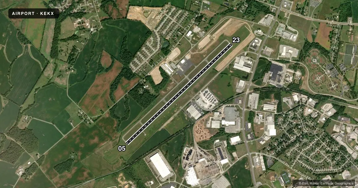
Runways & pattern
Full pagePattern entry · RWY 05
LEFT TRAFFICRunway end performance
| End | TORA | TODA | ASDA | LDA | VGSI | Approach lights | Obstruction |
|---|---|---|---|---|---|---|---|
| 05 | — | — | — | — | PAPI 4-box left(3°) | — | 10', trees, 299' from thr, 214' R of cntrln, slope 9 |
| 23 | — | — | — | — | PAPI 4-box left(3°) | — | 10', trees, 447' from thr, 552' R of cntrln, slope 24 |
Declared distances in feet. TORA = takeoff run available, TODA = takeoff distance, ASDA = accelerate-stop, LDA = landing distance.
Airport sketch
Runways drawn to scale from FAA survey coordinates, rendered over satellite imagery. Not for navigation.
Approaches & charts
ILS · 1
Services on the field
Fuel grades, oxygen, maintenance, ramp storage and lighting — as declared to the FAA by the airport operator.
Fuel & services
- Fuel
- 100LLA+
- Airframe repair
- Major
- Power plant repair
- Major
- Other services
- AVNCS,INSTR,RNTL
Ramp & ground
- Transient storage
- Tie-down
- Hangar
- Landing fee
- No fee published
- Lighting schedule
- SEE RMK
- Beacon schedule
- SS-SR
- Beacon
- White / Green (civil land)(WG)
- Wind indicator
- Lighted
- Segmented circle
- Yes
Fuel & FBOs
Cheapest 100LL and Jet A on the field and nearby. Always confirm with the FBO before taxi.
Airport notes
Surface conditions, obstructions, local procedures, lighting outages and other notes published with each FAA cycle.
General notes
- PAJA, BIRDS ON & INVOF ARPT.
- FOR CD CTC LOUISVILLE APCH AT 502-375-7499
- TWY D CLSD TO ACFT WITH WINGSPAN MORE THAN 50 FT OR MORE THAN 12500 LBS GWT.
- AFT HR - 270-766-8420. FUEL AVBL H24 WITH CREDIT CARD.
Lighting notes
- ACTVT REIL RWY 05; MIRL RWY 05/23 - CTAF. PAPI RWY 05 & 23 OPR CONSLY.
Other notes
- MANAGER270-769-9100.
- OWNERDONALD WISE.
VFR map & nearby airports
VFR sectional. Tap any ICAO chip to open that airport.
Key facts · KEKX
Answer card- ICAO
- KEKX
- Name
- ADDINGTON FLD
- Location
- ELIZABETHTOWN, KENTUCKY
- Elevation
- 775.9 ft MSL
- Traffic pattern altitude
- 1,775.9 ft MSL (1,000 AGL)
- Control tower
- Non-towered (use CTAF)
- Total runways
- 1
- Longest runway
- 05/23 · 6,001 ft
- Published ILS approaches
- 1
- Published frequencies
- 5
- Magnetic variation
- 3°
- Current flight rules
- VFR
- Current wind
- 000° at 0 kt
- Favored runway now
- –
Addington Fld sits in Elizabethtown, Kentucky. The field elevation is 775.9 ft MSL. It has one runway. Runway 05/23 is 6,001 ft of asphalt. There is no control tower. Pattern altitude is not published. Use the standard 1,000 ft AGL pattern for light piston operations unless the current Chart Supplement says otherwise.
The airport has one ILS approach. It is for runway 05. That makes the field useful for IFR work in lower ceilings or reduced visibility. CTAF and UNICOM are both 123.075. Louisville Approach handles clearance delivery and approach or departure work on the published frequencies.
Elizabethtown Flying Service is on the field. It carries 100LL, Jet A and Jet A Prist. Fuel is available 24 hours with credit card. After hours contact is published in the Chart Supplement. The remarks also note birds on and near the airport. Taxiway D is closed to aircraft with wingspan more than 50 ft or gross weight more than 12,500 lb. Runway end identifier lights are on runway 05. Medium intensity runway lights are on runways 05 and 23. The PAPI on both ends operates continuously.
For a first-time arrival, the main things to plan for are the single-runway layout, the non-towered traffic flow and the published lighting setup if you are arriving at night. Check the current Chart Supplement for any updated local procedures before you go.