METAR & TAF 6I2
Current METAR
Observed 06:15Z
K6I2 270615Z AUTO 17004KT 8SM CLR 23/23 A2993 RMK AO2
- Wind
- 170° @ 4 kt
- Visibility
- 8 SM
- Temp / Dew
- 23°C / 23°C
- Altimeter
- 29.93 inHg
- Clouds
- CLR
- Density alt
- 2,028 ft
- Ceiling
- Unlimited
- Rules
- VFR
Airport info & contacts
Manager on record, flight service, ARTCC, attendance schedule and pattern altitude — published by the FAA and refreshed every 28 days.
Location
- From city
- 3 NM S
- VFR sectional
- ST LOUIS
- ARTCC
- ZID · INDIANAPOLIS
- NOTAM facility
- LOU (NOTAM-D)
Airport manager
- Name
- CHRIS CARTER
- Phone
- 859-336-3818
- Address
- 650 AIRPORT LANE, SPRINGFIELD KY 40069
Flight service · Hours
- FSS LOU
- LOUISVILLE1-800-WX-BRIEF
- Attendance
- 0800-1700
Frequencies
Tap any row to copy the frequency to your clipboard.
Runways & pattern
Full pagePattern entry · RWY 11
LEFT TRAFFICRunway end performance
| End | TORA | TODA | ASDA | LDA | VGSI | Approach lights | Obstruction |
|---|---|---|---|---|---|---|---|
| 11 | — | — | — | — | PAPI 4-box left(3°) | — | — |
| 29 | — | — | — | — | PAPI 4-box left(3.3°) | — | — |
Declared distances in feet. TORA = takeoff run available, TODA = takeoff distance, ASDA = accelerate-stop, LDA = landing distance.
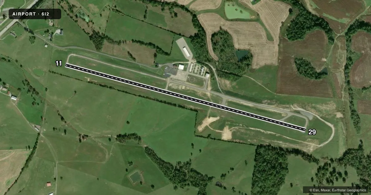
Airport sketch
Runways drawn to scale from FAA survey coordinates, rendered over satellite imagery. Not for navigation.
Approaches & charts
Services on the field
Fuel grades, oxygen, maintenance, ramp storage and lighting — as declared to the FAA by the airport operator.
Fuel & services
- Fuel
- 100LLA+
- Other services
- INSTR
Ramp & ground
- Transient storage
- Tie-down
- Landing fee
- No fee published
- Customs
- Not available
- Lighting schedule
- SEE RMK
- Beacon schedule
- SS-SR
- Beacon
- White / Green (civil land)(WG)
- Wind indicator
- Lighted
- Segmented circle
- Yes
Fuel & FBOs
Cheapest 100LL and Jet A on the field and nearby. Always confirm with the FBO before taxi.
Airport notes
Surface conditions, obstructions, local procedures, lighting outages and other notes published with each FAA cycle.
General notes
- FOR CD CTC LOUISVILLE APCH AT 502-375-7499.
Lighting notes
- ACTVT REIL RWY 11 & 29; PAPI RWY 11 & 29 ; MIRL RWY 11/29 - CTAF.
Fuel notes
- 100LLAVBL 24/7 WITH CC.
Approach & departure obstructions
- 29TREES NE VIOLATE 7:1 TRSN SFC.
- 29APCH RATIO 30:1 TO DTHR.
Other notes
- VFR USE ONLY.
- AND MARION CO.
VFR map & nearby airports
VFR sectional. Tap any ICAO chip to open that airport.
Key facts · 6I2
Answer card- ICAO
- 6I2
- Name
- LEBANON SPRINGFIELD/GEORGE HOERTER FLD
- Location
- SPRINGFIELD, KENTUCKY
- Elevation
- 871.2 ft MSL
- Traffic pattern altitude
- 1,871.2 ft MSL (1,000 AGL)
- Control tower
- Non-towered (use CTAF)
- Total runways
- 1
- Longest runway
- 11/29 · 5,001 ft
- Published ILS approaches
- 0
- Published frequencies
- 4
- Magnetic variation
- 5°
- Current flight rules
- VFR
- Current wind
- 170° at 4 kt
- Favored runway now
- RWY 11
Lebanon Springfield/George Hoerter Fld sits in Springfield, Kentucky in Marion County. Field elevation is 871.2 ft MSL. The airport has one runway. Runway 11/29 is 5,001 ft long with asphalt pavement. There is no control tower. The field uses CTAF 122.8. Louisville Approach handles departure and approach work on 132.075 and 327.0. No ILS approaches are published here. The airport is for VFR use only.
Pattern altitude is not published. Use 1,000 ft AGL for light piston operations unless the current Chart Supplement says otherwise. The on-field FBO is Lebanon-Springfield Airport. It carries 100LL and Jet A. 100LL is available 24 hours a day with a credit card. That is useful for late arrivals or early departures.
There are a few runway notes worth knowing before you go. Runway 11 and 29 have medium intensity runway lights. PAPI is installed on both ends. Runway end identifier lights are active on 11 and 29. The approach to the displaced threshold on runway 29 has a 30:1 ratio. Trees northeast of runway 29 violate the 7:1 transition surface. Plan your visual approach carefully. If you need clearance delivery, contact Louisville Approach at 502-375-7499.