METAR & TAF KJVY
Current METAR
Observed 13:15Z
KJVY 271315Z AUTO 00000KT 10SM BKN014 25/25 A2991 RMK AO2
- Wind
- 000° @ 0 kt
- Visibility
- 10 SM
- Temp / Dew
- 25°C / 25°C
- Altimeter
- 29.91 inHg
- Clouds
- BKN
- Density alt
- 1,805 ft
- Ceiling
- 1,400 ft AGL
- Rules
- MVFR
Airport info & contacts
Manager on record, flight service, ARTCC, attendance schedule and pattern altitude — published by the FAA and refreshed every 28 days.
Location
- From city
- 5 NM N
- VFR sectional
- ST LOUIS
- Pattern altitude
- 800 ft AGL · 1,278 ft MSL
- ARTCC
- ZID · INDIANAPOLIS
- NOTAM facility
- HUF (NOTAM-D)
Airport manager
- Name
- JOHN SECOR
- Phone
- 812-246-7460
- Address
- 6003 PROPELLER LANE, SELLERSBURG IN 47172
Flight service · Hours
- FSS HUF
- TERRE HAUTE1-800-WX-BRIEF
- Attendance
- 0600-2300
Frequencies
Tap any row to copy the frequency to your clipboard.
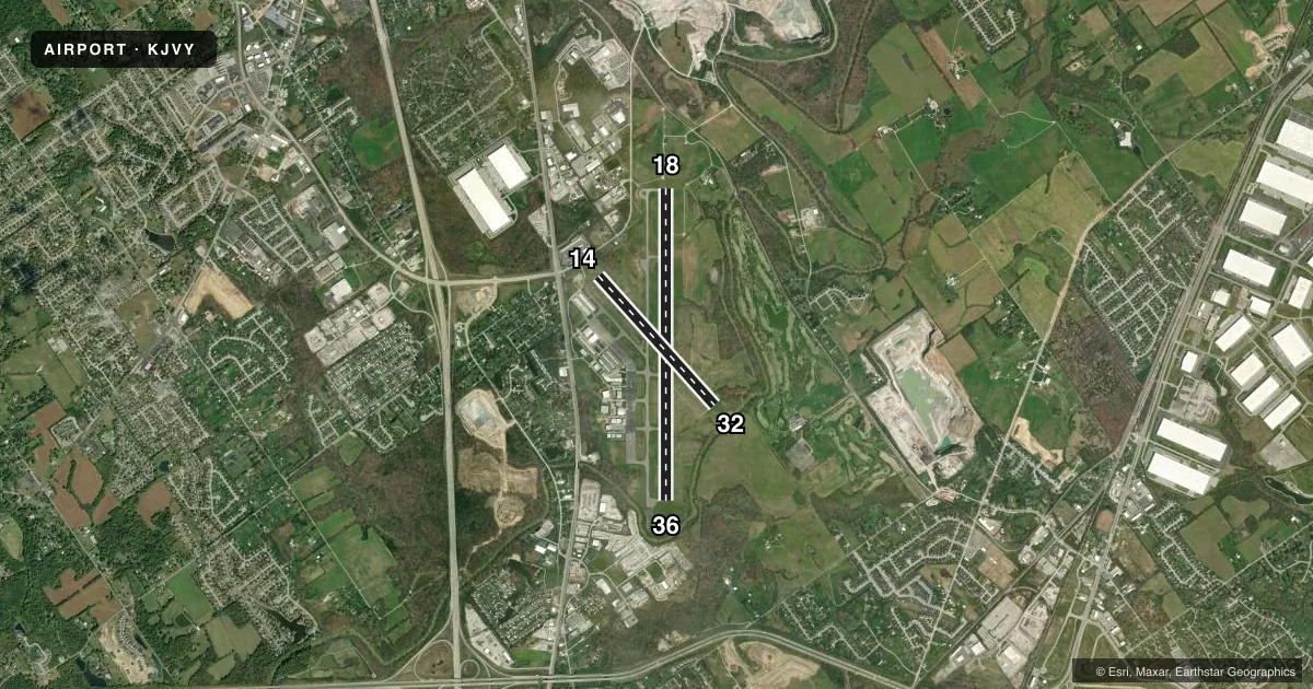
Runways & pattern
Full pagePattern entry · RWY 18
LEFT TRAFFIC| Runway | Heading (°M) | Length | Surface | Traffic |
|---|---|---|---|---|
| 18/36 | 178° / 358° | 7,000 ft | ASPH | Standard L |
| 14/32 | 136° / 316° | 3,899 ft | ASPH | Standard L |
Runway end performance
| End | TORA | TODA | ASDA | LDA | VGSI | Approach lights | Obstruction |
|---|---|---|---|---|---|---|---|
| 18 | — | — | — | — | PAPI 4-box left(3°) | MALSR | 70', pline, 3150' from thr, 894' R of cntrln, slope 42 |
| 36 | — | — | — | — | PAPI 4-box left(3°) | — | 36', tree, 750' from thr, 120' R of cntrln, slope 15 |
| 14 | — | — | — | — | PAPI 2-box left(3.9°) | — | — |
| 32 | — | — | — | — | PAPI 2-box left(3.9°) | — | — |
Declared distances in feet. TORA = takeoff run available, TODA = takeoff distance, ASDA = accelerate-stop, LDA = landing distance.
Airport sketch
Runways drawn to scale from FAA survey coordinates, rendered over satellite imagery. Not for navigation.
Approaches & charts
ILS · 1
Services on the field
Fuel grades, oxygen, maintenance, ramp storage and lighting — as declared to the FAA by the airport operator.
Fuel & services
- Fuel
- 100LLA
- Oxygen (bottled)
- High pressure
- Oxygen (bulk)
- High pressure
- Airframe repair
- Major
- Power plant repair
- Major
- Other services
- AFRT,CARGO,CHTR,INSTR,RNTL,SALES
Ramp & ground
- Transient storage
- Tie-down
- Hangar
- Lighting schedule
- SEE RMK
- Beacon schedule
- SS-SR
- Beacon
- White / Green (civil land)(WG)
- Wind indicator
- Lighted
- Segmented circle
- Yes
Fuel & FBOs
Cheapest 100LL and Jet A on the field and nearby. Always confirm with the FBO before taxi.
Airport notes
Surface conditions, obstructions, local procedures, lighting outages and other notes published with each FAA cycle.
General notes
- STUDENT ACT & WILDLIFE ON & INVOF ARPT.
- LNDG FEE FOR NON BASE ACFT.
- EMERG PHONE LCTD N SIDE OF AUTH BLDG - CTAF TO OPEN.
- FOR CD CTC LOUISVILLE APCH AT 502-375-7499
Lighting notes
- REIL RWY 14 & 32; REIL RWY 36; MIRL RWY 18/36 & 14/32 OPR SS-SR AND PRESET MED INTST; TO INCR INTST AND ACTVT MALSR RWY 18 - CTAF. PAPI RWY 18 & 36; PAPI RWY 14 & 32 OPR CONSLY.
Fuel notes
- AAVBL 0600-2300, AFT HRS CALL AHD RQRD.
VFR map & nearby airports
VFR sectional. Tap any ICAO chip to open that airport.
Key facts · KJVY
Answer card- ICAO
- KJVY
- Name
- CLARK RGNL
- Location
- JEFFERSONVILLE, INDIANA
- Elevation
- 477.7 ft MSL
- Traffic pattern altitude
- 1,277.7 ft MSL (800 AGL)
- Control tower
- Non-towered (use CTAF)
- Total runways
- 2
- Longest runway
- 18/36 · 7,000 ft
- Published ILS approaches
- 1
- Published frequencies
- 5
- Magnetic variation
- 2°
- Current flight rules
- MVFR
- Current wind
- 000° at 0 kt
- Favored runway now
- –
Clark Rgnl is in Jeffersonville, Indiana. The field elevation is 477.7 ft MSL. It has two asphalt runways. The longest is 7,000 ft on runway 18/36. This is a non-towered airport. The pattern altitude is 800 ft AGL, which is 1,277.7 ft MSL.
Runway 18 has the published ILS. Runway 18 also has medium intensity approach lighting with runway alignment indicator lights. Use CTAF to increase the intensity. Runway end identifier lights are installed on runways 14, 32 and 36. PAPI is installed on runways 18 and 36. The PAPI on 14 and 32 runs continuously.
Two on-field FBOs are listed. Aircraft Specialists carries 100LL, Jet A and Jet A Prist. Honaker Aviation carries 100LL and Jet A Prist. Student activity and wildlife are present on and near the airport. Keep a sharp scan in the pattern and on taxi. There is a landing fee for non-based aircraft. For clearance delivery, contact Louisville Approach. If you need current airport procedures or any local restrictions, check the current FAA Chart Supplement or call the airport operator or FBO directly.