METAR & TAF 64I
64I does not publish a METAR.
Showing the nearest reporting station: KIMS (MADISON RGNL) · 7.8 NM away. Conditions at 64I may differ.
METAR · KIMS
Observed 13:35Z
KIMS 271335Z AUTO 00000KT 3/4SM BR OVC002 23/23 A2996 RMK AO2
- Wind
- 000° @ 0 kt
- Visibility
- 0.75 SM
- Temp / Dew
- 23°C / 23°C
- Altimeter
- 29.96 inHg
- Clouds
- OVC
- Density alt
- 1,497 ft
- Ceiling
- 200 ft AGL
- Rules
- LIFR
Airport info & contacts
Manager on record, flight service, ARTCC, attendance schedule and pattern altitude — published by the FAA and refreshed every 28 days.
Location
- From city
- 6 NM S
- VFR sectional
- ST LOUIS
- ARTCC
- ZID · INDIANAPOLIS
- NOTAM facility
- HUF (NOTAM-D)
Airport manager
- Name
- RICH & GINGER DAVIDSON
- Phone
- 812-866-3211
- Address
- 7296 S RIVER BOTTOM ROAD, HANOVER IN 47243
Flight service · Hours
- FSS HUF
- TERRE HAUTE1-800-WX-BRIEF
- Attendance
- IREG · DALGT
Frequencies
Tap any row to copy the frequency to your clipboard.
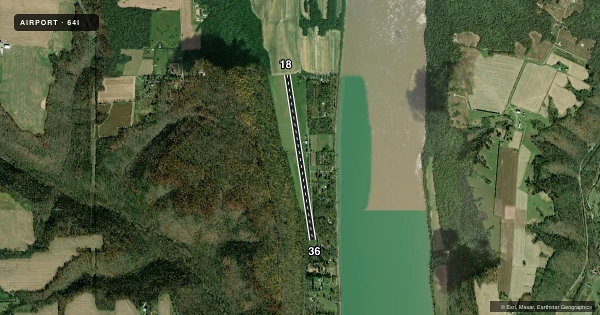
Runways & pattern
Full pagePattern entry · RWY 18
LEFT TRAFFICRunway end performance
| End | TORA | TODA | ASDA | LDA | VGSI | Approach lights | Obstruction |
|---|---|---|---|---|---|---|---|
| 18 | — | — | — | — | — | — | 10', crops, 210' from thr, 0' R of cntrln, slope 21 |
| 36 | — | — | — | — | — | — | 40', trees, 0' from thr, 60' R of cntrln, slope 0 |
Declared distances in feet. TORA = takeoff run available, TODA = takeoff distance, ASDA = accelerate-stop, LDA = landing distance.
Airport sketch
Runways drawn to scale from FAA survey coordinates, rendered over satellite imagery. Not for navigation.
Approaches & charts
Services on the field
Fuel grades, oxygen, maintenance, ramp storage and lighting — as declared to the FAA by the airport operator.
Fuel & services
- Fuel
- Not available
Ramp & ground
- Transient storage
- Tie-down
- Wind indicator
- Yes
- Segmented circle
- Yes
Fuel & FBOs
Cheapest 100LL and Jet A on the field and nearby. Always confirm with the FBO before taxi.
Airport notes
Surface conditions, obstructions, local procedures, lighting outages and other notes published with each FAA cycle.
General notes
- FOR CD CTC LOUISVILLE APCH AT 502-375-7499
Runway surface & condition
- 18/3630 FT DROPOFF S END; 5-10 FT DROPOFF 25 FT EACH SIDE OF RWY S 1700 FT.
- 18W/36WELEV FLUCTUATES.
Approach & departure obstructions
- 18WHITE TRAFFIC CONES.
- 36WHITE TRAFFIC CONES.
- 36APCH SLOPE 20:1 FM DSPLCD THR; 50 FT TREES 80 FT L & 150 FT R.
Other notes
- PRVDD OBSTN LOWERED/CLRD OR DSPLD THLD; AREA 125 FT FM CNTRLN & 200 FT OFF ENDS IS CLEAR; AREA 60 FT FM CNTRLN & 240 FT OFF ENDS HAS NO SFC HAZARDS.
VFR map & nearby airports
VFR sectional. Tap any ICAO chip to open that airport.
Key facts · 64I
Answer card- ICAO
- 64I
- Name
- LEE BOTTOM
- Location
- HANOVER, INDIANA
- Elevation
- 473 ft MSL
- Traffic pattern altitude
- 1,473 ft MSL (1,000 AGL)
- Control tower
- Non-towered (use CTAF)
- Total runways
- 1
- Longest runway
- 18/36 · 4,080 ft
- Published ILS approaches
- 0
- Published frequencies
- 1
- Magnetic variation
- 2°
- Current flight rules
- LIFR
- Current wind
- 000° at 0 kt
- Favored runway now
- –
Lee Bottom Airport sits near Hanover, Indiana. Field elevation is 473 ft MSL. It has one runway. The longest is 18/36 at 4,080 ft on turf. The airport is not towered. CTAF is 122.9. No ILS approaches are published. Pattern altitude is not published, so use the standard 1,000 ft AGL for light piston traffic unless the current Chart Supplement says otherwise.
The published remarks matter here. Runway 18 is marked with white traffic cones. Runway 36 is also marked with white traffic cones. The south end has a 30-foot dropoff. There is also a 5 to 10-foot dropoff 25 feet each side of the runway south 1,700 feet. Runway 36 has trees close in on the approach side, with a published 20:1 slope from the displaced threshold. That is a field where a careful walk-through of the current notes pays off before you launch.
No on-field FBOs are listed. Contact the airport operator directly before arrival if you need fuel or ramp details. For clearance delivery, the published contact is Louisville Approach at 502-375-7499. Pilots should also verify current runway condition and any local operating notes before using the turf surface, especially after rain or during soft-field conditions.