METAR & TAF 8I1
8I1 does not publish a METAR.
Showing the nearest reporting station: KIMS (MADISON RGNL) · 13.1 NM away. Conditions at 8I1 may differ.
METAR · KIMS
Observed 05:55Z
KIMS 270555Z AUTO 11003KT 10SM SCT017 OVC023 23/23 A2995 RMK AO2
- Wind
- 110° @ 3 kt
- Visibility
- 10 SM
- Temp / Dew
- 23°C / 23°C
- Altimeter
- 29.95 inHg
- Clouds
- OVC
- Density alt
- 1,523 ft
- Ceiling
- 2,300 ft AGL
- Rules
- MVFR
Airport info & contacts
Manager on record, flight service, ARTCC, attendance schedule and pattern altitude — published by the FAA and refreshed every 28 days.
Location
- From city
- 7 NM SW
- VFR sectional
- ST LOUIS
- Pattern altitude
- 800 ft AGL · 1,284 ft MSL
- ARTCC
- ZID · INDIANAPOLIS
- NOTAM facility
- HUF (NOTAM-D)
Airport manager
- Name
- CLIFF ROBINSON
- Phone
- 812-701-9990
- Address
- 220 CLIFTY DR., MADISON IN 47250
Flight service · Hours
- FSS HUF
- TERRE HAUTE1-800-WX-BRIEF
- Attendance
- IREG
Frequencies
Tap any row to copy the frequency to your clipboard.
Runways & pattern
Full pagePattern entry · RWY 09
LEFT TRAFFICRunway end performance
| End | TORA | TODA | ASDA | LDA | VGSI | Approach lights | Obstruction |
|---|---|---|---|---|---|---|---|
| 09 | — | — | — | — | — | — | 10', road, 10' from thr, 0' R of cntrln, slope 1 |
| 27 | — | — | — | — | — | — | 15', road, 0' from thr, 125' R of cntrln, slope 0 |
Declared distances in feet. TORA = takeoff run available, TODA = takeoff distance, ASDA = accelerate-stop, LDA = landing distance.
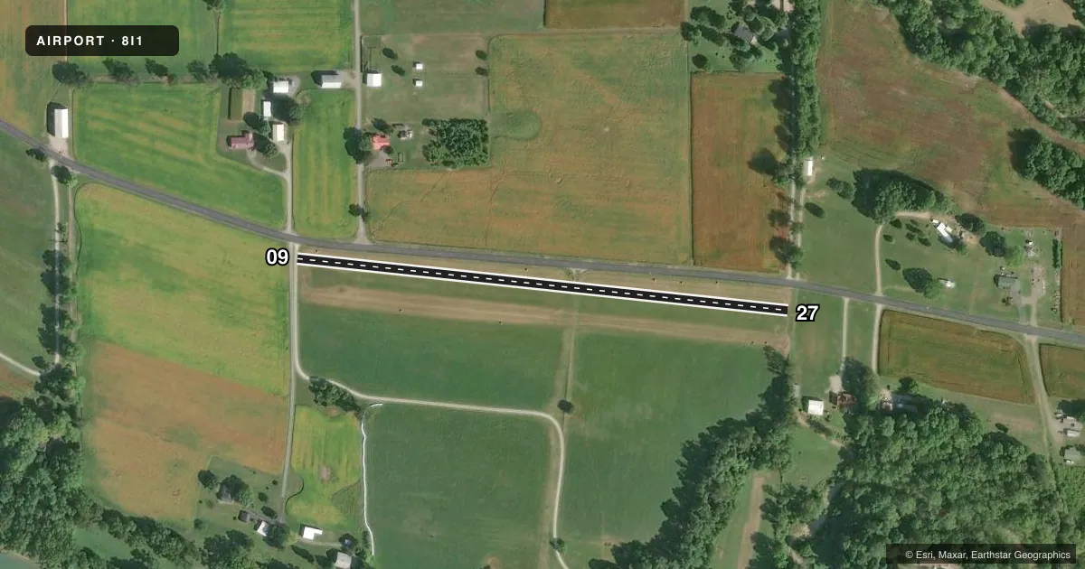
Airport sketch
Runways drawn to scale from FAA survey coordinates, rendered over satellite imagery. Not for navigation.
Approaches & charts
Services on the field
Fuel grades, oxygen, maintenance, ramp storage and lighting — as declared to the FAA by the airport operator.
Fuel & services
- Fuel
- Not available
Ramp & ground
- Transient storage
- Tie-down
- Landing fee
- No fee published
- Wind indicator
- Yes
- Segmented circle
- No
Fuel & FBOs
Cheapest 100LL and Jet A on the field and nearby. Always confirm with the FBO before taxi.
Airport notes
Surface conditions, obstructions, local procedures, lighting outages and other notes published with each FAA cycle.
General notes
- FOR CD CTC CINCINNATI APCH AT 859-372-6440
Approach & departure obstructions
- 09RWY 09 /27 THLDS MKD WITH WHT TIRES; BNDRY MKD WITH WHITE TIRES & YELLOW OIL JUGS.
- 09APCH SLOPE 20:1 AT DSPLCD THLD DUE TO 45 FT TREE 780 FT FM RWY END
- 2715 FT ROAD 90 FT N PARALLELS RWY
Other notes
- 09/27ROUGH & ROLLING TURF.
VFR map & nearby airports
VFR sectional. Tap any ICAO chip to open that airport.
Key facts · 8I1
Answer card- ICAO
- 8I1
- Name
- ROBINSON
- Location
- VEVAY, INDIANA
- Elevation
- 484 ft MSL
- Traffic pattern altitude
- 1,284 ft MSL (800 AGL)
- Control tower
- Non-towered (use CTAF)
- Total runways
- 1
- Longest runway
- 09/27 · 1,670 ft
- Published ILS approaches
- 0
- Published frequencies
- 1
- Magnetic variation
- 3°
- Current flight rules
- MVFR
- Current wind
- 110° at 3 kt
- Favored runway now
- RWY 09
Robinson Airport (8I1) sits in Vevay, Indiana. Field elevation is 484 ft MSL. It has one runway, 09/27, which is 1,670 ft long and surfaced with turf. The airport is non-towered. CTAF is 122.9. No ILS approaches are published here.
Pattern altitude is 800 ft AGL. That puts the traffic pattern at 1,284 ft MSL. The runway surface is rough and rolling turf, so plan your rollout and braking with that in mind. Runway 09 has a displaced threshold because of a 45-foot tree 780 feet from the runway end. Runway 27 has a 15-foot road 90 feet north of the runway. The runway thresholds are marked with white tires. The boundary is marked with white tires and yellow oil jugs.
There are no on-field FBOs listed. Check with the airport operator or call the field on CTAF for current services before you go. For clearance delivery, contact Cincinnati Approach at 859-372-6440. Pilots should also verify the current Chart Supplement for any updated local procedures or restrictions. The field is small. It is turf-based and has no tower, so good position reports and a careful look at the runway condition matter on arrival.