METAR & TAF I83
I83 does not publish a METAR.
Showing the nearest reporting station: KBFR (VIRGIL I GRISSOM MUNI) · 19.7 NM away. Conditions at I83 may differ.
METAR · KBFR
Observed 13:15Z
KBFR 271315Z AUTO 22003KT 10SM FEW006 24/23 A2991 RMK AO2
- Wind
- 220° @ 3 kt
- Visibility
- 10 SM
- Temp / Dew
- 24°C / 23°C
- Altimeter
- 29.91 inHg
- Clouds
- FEW
- Density alt
- 2,134 ft
- Ceiling
- Unlimited
- Rules
- VFR
Airport info & contacts
Manager on record, flight service, ARTCC, attendance schedule and pattern altitude — published by the FAA and refreshed every 28 days.
Location
- From city
- 2 NM W
- VFR sectional
- ST LOUIS
- ARTCC
- ZID · INDIANAPOLIS
- NOTAM facility
- HUF (NOTAM-D)
Airport manager
- Name
- ARIC RUSSEL
- Phone
- 812-896-9723
- Address
- 334 N AIRPORT BLVD, SALEM IN 47167
Flight service · Hours
- FSS HUF
- TERRE HAUTE1-800-WX-BRIEF
- Attendance
- IREG
Frequencies
Tap any row to copy the frequency to your clipboard.
Runways & pattern
Full pagePattern entry · RWY 26
LEFT TRAFFICRunway end performance
| End | TORA | TODA | ASDA | LDA | VGSI | Approach lights | Obstruction |
|---|---|---|---|---|---|---|---|
| 08 | — | — | — | — | PAPI 2-box left(3°) | — | — |
Declared distances in feet. TORA = takeoff run available, TODA = takeoff distance, ASDA = accelerate-stop, LDA = landing distance.
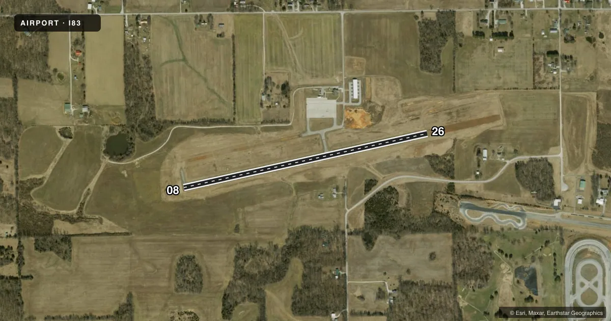
Airport sketch
Runways drawn to scale from FAA survey coordinates, rendered over satellite imagery. Not for navigation.
Approaches & charts
Services on the field
Fuel grades, oxygen, maintenance, ramp storage and lighting — as declared to the FAA by the airport operator.
Fuel & services
- Fuel
- 100LL
- Other services
- INSTR
Ramp & ground
- Transient storage
- Tie-down
- Landing fee
- No fee published
- Customs
- Not available
- Lighting schedule
- SEE RMK
- Wind indicator
- Lighted
- Segmented circle
- No
Fuel & FBOs
Cheapest 100LL and Jet A on the field and nearby. Always confirm with the FBO before taxi.
Airport notes
Surface conditions, obstructions, local procedures, lighting outages and other notes published with each FAA cycle.
General notes
- FOR CD CTC LOUISVILLE APCH AT 502-375-7499
Lighting notes
- ACTVT PAPI RWY 08; MIRL RWY 08/26 - CTAF. MIRL RWY 08/26 PRESET LOW INTST; INCR INTST - CTAF.
Fuel notes
- 100LLAVBL H24 WITH CREDIT CARD.
Other notes
- ROPE AND WHEEL CHOCKS PROVIDED
- UNICOM UNMNT.
- MANAGERTRML: 812-883-5858. AMGR: 812-896-9723.
VFR map & nearby airports
VFR sectional. Tap any ICAO chip to open that airport.
Key facts · I83
Answer card- ICAO
- I83
- Name
- SALEM MUNI
- Location
- SALEM, INDIANA
- Elevation
- 839.9 ft MSL
- Traffic pattern altitude
- 1,839.9 ft MSL (1,000 AGL)
- Control tower
- Non-towered (use CTAF)
- Total runways
- 1
- Longest runway
- 08/26 · 3,000 ft
- Published ILS approaches
- 0
- Published frequencies
- 4
- Magnetic variation
- 4°
- Current flight rules
- VFR
- Current wind
- 220° at 3 kt
- Favored runway now
- RWY 26
Salem Muni sits in Salem, Indiana. The field elevation is 839.9 ft MSL. It has one runway. The longest is runway 08/26 at 3,000 ft. There is no control tower. CTAF and UNICOM are both 123.0. UNICOM is unmanned.
No ILS approaches are published here. Pattern altitude is not published, so a light piston pilot should plan on the standard 1,000 ft AGL unless the current Chart Supplement says otherwise. Runway 08 has PAPI lighting. Medium intensity runway lights are installed on 08 and 26. They are controlled by CTAF. The lights are preset to low intensity. Use CTAF to increase intensity if needed.
Salem Municipal Airport is the on-field FBO. It carries 100LL. 100LL is available 24 hours a day with credit card. Rope and wheel chocks are provided. For clearance delivery, contact Louisville Approach at 502-375-7499. The published approach frequencies are 123.675 and 327.0 for Louisville. If you are planning a night arrival or a first trip in, expect a small non-towered field with basic services. Check the current Chart Supplement for any updates before you go.