METAR & TAF KEOP
Current METAR
Observed 23:15Z
KEOP 272315Z AUTO 00000KT 10SM FEW034 FEW120 26/26 A2983 RMK AO2
- Wind
- 000° @ 0 kt
- Visibility
- 10 SM
- Temp / Dew
- 26°C / 26°C
- Altimeter
- 29.83 inHg
- Clouds
- FEW
- Density alt
- 2,251 ft
- Ceiling
- Unlimited
- Rules
- VFR
Airport info & contacts
Manager on record, flight service, ARTCC, attendance schedule and pattern altitude — published by the FAA and refreshed every 28 days.
Location
- From city
- 3 NM NE
- VFR sectional
- CINCINNATI
- ARTCC
- ZID · INDIANAPOLIS
- NOTAM facility
- EOP (NOTAM-D)
Airport manager
- Name
- SARA JUNK
- Phone
- 740-947-4952
- Address
- 2577 ALMA OMEGA RD, WAVERLY OH 45690-9316
Flight service · Hours
- FSS DAY
- DAYTON1-800-WX-BRIEF
- Attendance
- MON-FRI · 0830-1630
Frequencies
Tap any row to copy the frequency to your clipboard.
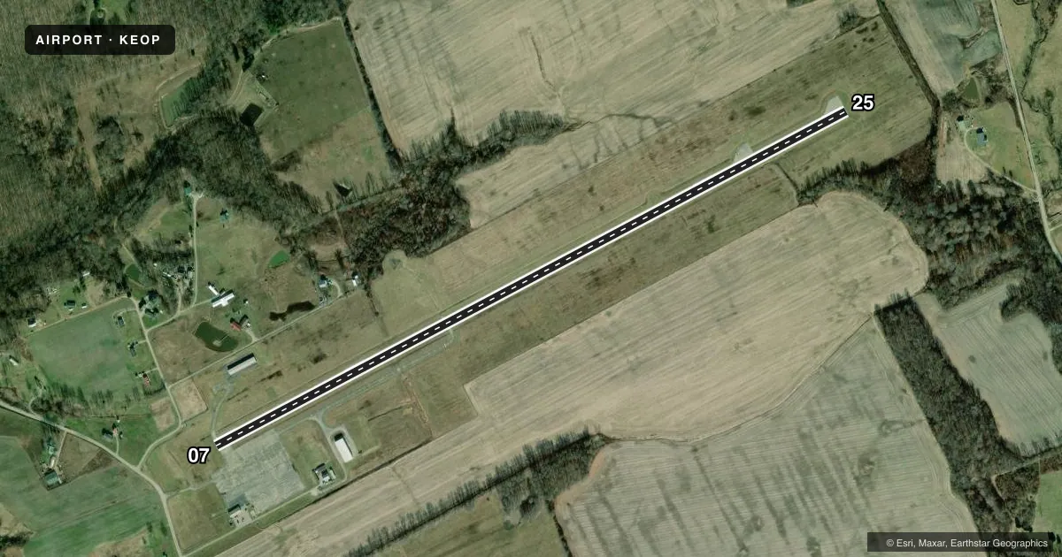
Runways & pattern
Full pagePattern entry · RWY 07
LEFT TRAFFICRunway end performance
| End | TORA | TODA | ASDA | LDA | VGSI | Approach lights | Obstruction |
|---|---|---|---|---|---|---|---|
| 07 | — | — | — | — | PAPI 4-box left(4°) | — | 10', road, 201' from thr, 205' R of cntrln, slope 0 |
| 25 | — | — | — | — | PAPI 4-box left(3°) | — | 46', tree, 664' from thr, 315' R of cntrln, slope 10 |
Declared distances in feet. TORA = takeoff run available, TODA = takeoff distance, ASDA = accelerate-stop, LDA = landing distance.
Airport sketch
Runways drawn to scale from FAA survey coordinates, rendered over satellite imagery. Not for navigation.
Approaches & charts
Services on the field
Fuel grades, oxygen, maintenance, ramp storage and lighting — as declared to the FAA by the airport operator.
Fuel & services
- Fuel
- 100LLA1+
- Oxygen (bottled)
- Not available
- Oxygen (bulk)
- Not available
- Airframe repair
- Major
- Power plant repair
- Major
Ramp & ground
- Transient storage
- Tie-down
- Landing fee
- No fee published
- Customs
- Not available
- Lighting schedule
- SEE RMK
- Beacon schedule
- SS-SR
- Beacon
- White / Green (civil land)(WG)
- Wind indicator
- Lighted
- Segmented circle
- No
Fuel & FBOs
Cheapest 100LL and Jet A on the field and nearby. Always confirm with the FBO before taxi.
Airport notes
Surface conditions, obstructions, local procedures, lighting outages and other notes published with each FAA cycle.
General notes
- BIRDS & OTR WILDLIFE ON & INVOF ARPT.
- FOR CD CTC INDIANAPOLIS ARTCC AT 317-247-2411.
Lighting notes
- ACTVT REIL RWY 07 & 25; MIRL RWY 07/25 - CTAF. PAPI RWY 07 & 25 OPR CONSLY.
Fuel notes
- 100LLFUEL AVBL H24 SELF SVC VIA CREDIT CARD.
Approach & departure obstructions
- 07+10 FT ROAD, 0-200 FT DIST, 205 FT L; +8 FT FENCE, 110-200 FT DIST, 180-190 FT L.
- 07CTLG OBSTN EXCEEDS A 45 DEG SLP.
Other notes
- VFR ONLY.
- 1EXCLDG MAJOR HOLS.
- MANAGEROR TIM DICKERSON 740-708-3941.
- MANAGERCELL 740-577-2644.
VFR map & nearby airports
VFR sectional. Tap any ICAO chip to open that airport.
Key facts · KEOP
Answer card- ICAO
- KEOP
- Name
- PIKE COUNTY
- Location
- WAVERLY, OHIO
- Elevation
- 661.1 ft MSL
- Traffic pattern altitude
- 1,661.1 ft MSL (1,000 AGL)
- Control tower
- Non-towered (use CTAF)
- Total runways
- 1
- Longest runway
- 07/25 · 4,899 ft
- Published ILS approaches
- 0
- Published frequencies
- 2
- Magnetic variation
- 6°
- Current flight rules
- VFR
- Current wind
- 000° at 0 kt
- Favored runway now
- –
Pike County Airport sits in Waverly, Ohio. Field elevation is 661.1 ft MSL. The airport has one runway. Runway 07/25 is 4,899 ft long with an asphalt surface. There is no control tower. CTAF and UNICOM are both 123.0. No ILS approaches are published, so plan for VFR or verify current instrument options in the FAA Chart Supplement before you go.
Pattern altitude is not published. Use 1,000 ft AGL for light piston traffic unless the current Chart Supplement says otherwise. The field is VFR only. Birds and other wildlife are reported on and near the airport. Keep a sharp scan on taxi, takeoff and landing. Runway 07 has published obstructions near the approach end. There is also a road and a fence close to that end, so brief the departure and arrival path carefully.
Pike County Airport is on the field and carries 100LL and Jet A. 100LL is available 24 hours a day through self-serve credit card. Runway end identifier lights are installed on 07 and 25. Medium intensity runway lights are controlled by CTAF. Precision approach path indicators operate continuously on both ends. For clearance delivery, contact Indianapolis ARTCC at 317-247-2411. If you need local help, the manager and Tim Dickerson are listed in the remarks with phone numbers.