METAR & TAF KJRO
Current METAR
Observed 12:55Z
KJRO 271255Z AUTO 00000KT 7SM BR FEW001 20/20 A2995 RMK AO2
- Wind
- 000° @ 0 kt
- Visibility
- 7 SM
- Temp / Dew
- 20°C / 20°C
- Altimeter
- 29.95 inHg
- Clouds
- FEW
- Density alt
- 1,463 ft
- Ceiling
- Unlimited
- Rules
- VFR
Airport info & contacts
Manager on record, flight service, ARTCC, attendance schedule and pattern altitude — published by the FAA and refreshed every 28 days.
Location
- From city
- 5 NM SE
- VFR sectional
- CINCINNATI
- ARTCC
- ZID · INDIANAPOLIS
- NOTAM facility
- JRO (NOTAM-D)
Airport manager
- Name
- DON LEWIS
- Phone
- 740-286-0137
- Address
- 1800 KEYSTONE STATION RD, JACKSON OH 45640-8701
Flight service · Hours
- FSS DAY
- DAYTON1-800-WX-BRIEF
- Attendance
- MON-FRI · 0800-1400
Frequencies
Tap any row to copy the frequency to your clipboard.
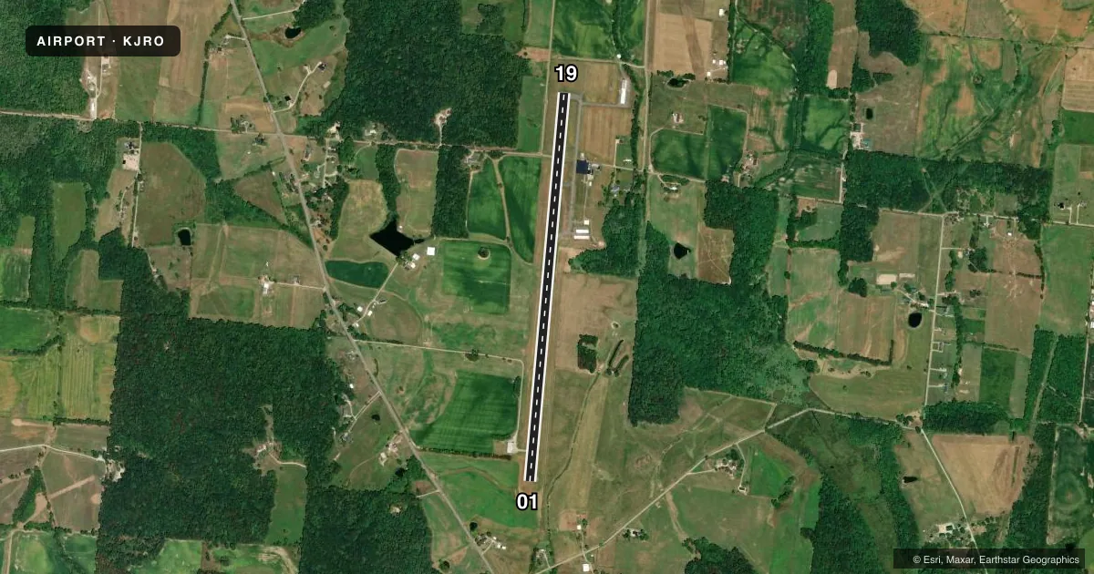
Runways & pattern
Full pagePattern entry · RWY 01
LEFT TRAFFICRunway end performance
| End | TORA | TODA | ASDA | LDA | VGSI | Approach lights | Obstruction |
|---|---|---|---|---|---|---|---|
| 01 | — | — | — | — | PAPI 4-box right(4°) | — | 75', tree, 919' from thr, 175' R of cntrln, slope 9 |
| 19 | — | — | — | — | PAPI 4-box left(4°) | — | 15', road, 201' from thr, 230' R of cntrln, slope 0 |
Declared distances in feet. TORA = takeoff run available, TODA = takeoff distance, ASDA = accelerate-stop, LDA = landing distance.
Airport sketch
Runways drawn to scale from FAA survey coordinates, rendered over satellite imagery. Not for navigation.
Approaches & charts
Services on the field
Fuel grades, oxygen, maintenance, ramp storage and lighting — as declared to the FAA by the airport operator.
Fuel & services
- Fuel
- 100LLA1+
- Oxygen (bottled)
- Not available
- Oxygen (bulk)
- Not available
- Airframe repair
- Major
- Power plant repair
- Major
- Other services
- INSTR,RNTL
Ramp & ground
- Transient storage
- Tie-down
- Landing fee
- No fee published
- Customs
- Not available
- Lighting schedule
- SEE RMK
- Beacon schedule
- SS-SR
- Beacon
- White / Green (civil land)(WG)
- Wind indicator
- Lighted
- Segmented circle
- No
Fuel & FBOs
Cheapest 100LL and Jet A on the field and nearby. Always confirm with the FBO before taxi.
Airport notes
Surface conditions, obstructions, local procedures, lighting outages and other notes published with each FAA cycle.
General notes
- FOR CD CTC HUNTINGTON ATCT AT 304-453-2490.
Lighting notes
- ACTVT MIRL RWY 01/19 - CTAF. PAPI RWY 01 & 19 OPR CONSLY.
Fuel notes
- 100LL100LL & JET A1+ AVBL H24 SELF SVC VIA CREDIT CARD.
Approach & departure obstructions
- 1915 FT ROAD, 0-200 FT DIST, 230 FT R.
- 01PAPI UNUSBL BYD 9 DEGS LEFT OF CNTRLN.
- 19PAPI UNUSBL BYD 7 DEGS RIGHT OF CNTRLN.
- 01APCH RATIO 15:1 TO DTHR.
VFR map & nearby airports
VFR sectional. Tap any ICAO chip to open that airport.
Key facts · KJRO
Answer card- ICAO
- KJRO
- Name
- JAMES A RHODES
- Location
- JACKSON, OHIO
- Elevation
- 726.2 ft MSL
- Traffic pattern altitude
- 1,726.2 ft MSL (1,000 AGL)
- Control tower
- Non-towered (use CTAF)
- Total runways
- 1
- Longest runway
- 01/19 · 5,201 ft
- Published ILS approaches
- 0
- Published frequencies
- 4
- Magnetic variation
- 5°
- Current flight rules
- VFR
- Current wind
- 000° at 0 kt
- Favored runway now
- –
James A Rhodes Airport sits in Jackson, Ohio. Field elevation is 726.2 ft MSL. The airport has one runway. Runway 01/19 is 5,201 ft long and paved with asphalt. There is no control tower. No ILS approaches are published here. Pattern altitude is not published in the facts, so use the standard 1,000 ft AGL for light piston operations unless the current FAA Chart Supplement says otherwise.
This is a non-towered field, so plan to self-announce on CTAF 122.7. UNICOM is also 122.7. The published approach and departure frequencies are listed for Huntington. For clearance delivery, the Chart Supplement says to contact Huntington Air Traffic Control Tower at 304-453-2490. The on-field FBO is James A. Rhodes Airport. It carries 100LL and Jet A. The published remarks also note 24-hour self-serve fuel with credit card access.
A few runway notes matter here. The approach slope to the displaced threshold on runway 01 is 15 to 1. The PAPI on runway 01 is unusable beyond 9 degrees left of centerline. On runway 19, there is a 15-foot road near the runway end on the right side. The PAPI on runway 19 is unusable beyond 7 degrees right of centerline. Medium intensity runway lights are activated by CTAF. For a first-time arrival, review the runway lighting and the displaced threshold notes before you go.