METAR & TAF KPMH
Current METAR
Observed 10:15Z
KPMH 271015Z AUTO 32002KT M1/4SM FG OVC001 18/18 A2992 RMK AO2
- Wind
- 320° @ 2 kt
- Visibility
- —
- Temp / Dew
- 18°C / 18°C
- Altimeter
- 29.92 inHg
- Clouds
- OVC
- Density alt
- 1,183 ft
- Ceiling
- 100 ft AGL
- Rules
- LIFR
Airport info & contacts
Manager on record, flight service, ARTCC, attendance schedule and pattern altitude — published by the FAA and refreshed every 28 days.
Location
- From city
- 10 NM NE
- VFR sectional
- CINCINNATI
- ARTCC
- ZID · INDIANAPOLIS
- NOTAM facility
- PMH (NOTAM-D)
Airport manager
- Name
- JOSH GREEN
- Phone
- 740-820-2700
- Address
- 138 BARKLOW RD, PORTSMOUTH OH 45662-8691
Flight service · Hours
- FSS DAY
- DAYTON1-800-WX-BRIEF
- Attendance
- 0900-1700
Frequencies
Tap any row to copy the frequency to your clipboard.
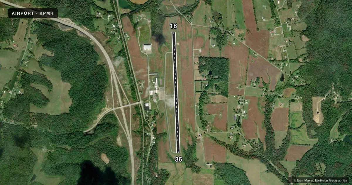
Runways & pattern
Full pagePattern entry · RWY 36
LEFT TRAFFICRunway end performance
| End | TORA | TODA | ASDA | LDA | VGSI | Approach lights | Obstruction |
|---|---|---|---|---|---|---|---|
| 18 | — | — | — | — | PAPI 4-box left(3°) | — | — |
| 36 | — | — | — | — | PAPI 4-box left(3°) | — | — |
Declared distances in feet. TORA = takeoff run available, TODA = takeoff distance, ASDA = accelerate-stop, LDA = landing distance.
Airport sketch
Runways drawn to scale from FAA survey coordinates, rendered over satellite imagery. Not for navigation.
Approaches & charts
Services on the field
Fuel grades, oxygen, maintenance, ramp storage and lighting — as declared to the FAA by the airport operator.
Fuel & services
- Fuel
- 100LLA1+
- Oxygen (bottled)
- Not available
- Oxygen (bulk)
- Not available
- Airframe repair
- Major
- Power plant repair
- Major
- Other services
- AMB,INSTR,RNTL
Ramp & ground
- Transient storage
- Tie-down
- Hangar
- Landing fee
- Yes
- Customs
- Not available
- Lighting schedule
- SEE RMK
- Beacon schedule
- SS-SR
- Beacon
- White / Green (civil land)(WG)
- Wind indicator
- Lighted
- Segmented circle
- No
Fuel & FBOs
Cheapest 100LL and Jet A on the field and nearby. Always confirm with the FBO before taxi.
Airport notes
Surface conditions, obstructions, local procedures, lighting outages and other notes published with each FAA cycle.
General notes
- HILL OBSTN LGTS 460 FT ABV ARPT (1124 FT MSL) 1 MI S & 410 FT ABV ARPT (1074 FT MSL) 1/2 MI NW.
- NO LINE OF SIGHT BTN RWY ENDS.
- FOR CD CTC HUNTINGTON ATCT AT 304-453-2490.
Lighting notes
- ACTVT REIL RWY 18 & 36; MIRL RWY 18/36 - CTAF. PAPI RWY 18 & 36 OPR CONSLY.
Other notes
- ESTABD BFR 1959.
- LDG FEE FOR TURBINE ACFT WAIVED WITH FUEL PURCHASE, CTC ARPT FOR DTLS.
VFR map & nearby airports
VFR sectional. Tap any ICAO chip to open that airport.
Key facts · KPMH
Answer card- ICAO
- KPMH
- Name
- GREATER PORTSMOUTH RGNL
- Location
- PORTSMOUTH, OHIO
- Elevation
- 663.4 ft MSL
- Traffic pattern altitude
- 1,663.4 ft MSL (1,000 AGL)
- Control tower
- Non-towered (use CTAF)
- Total runways
- 1
- Longest runway
- 18/36 · 5,001 ft
- Published ILS approaches
- 0
- Published frequencies
- 4
- Magnetic variation
- 5°
- Current flight rules
- LIFR
- Current wind
- 320° at 2 kt
- Favored runway now
- RWY 36
Greater Portsmouth Rgnl is in Portsmouth, Ohio. The field elevation is 663.4 ft MSL. It has one runway, 18/36, which is 5,001 ft long. There is no control tower on the field. Approach and departure service is listed through Huntington on 128.4 and 270.1 MHz. No ILS approaches are published here.
The pattern altitude is not published. Use the standard 1,000 ft AGL pattern for light piston aircraft unless the current Chart Supplement says otherwise. PMH Aviation is on the field. It carries 100LL and Jet A Prist. Runway end identifier lights are installed on 18 and 36. Medium intensity runway lights are controlled by the CTAF. PAPI is available on both runway ends and operates continuously.
This is a field where the surrounding terrain matters. Published remarks note hill obstruction lights south of the airport and northwest of the airport. There is also no line of sight between runway ends. For clearance delivery, contact Huntington Air Traffic Control Tower. If you are planning a turbine arrival, ask the airport about the landing fee waiver tied to fuel purchase. Check the current FAA Chart Supplement for any local operating notes before you go.