METAR & TAF KFCI
Current METAR
Observed 16:04Z
KFCI 271604Z AUTO 04003KT 10SM SCT030 28/21 A2988 RMK AO2 $
- Wind
- 040° @ 3 kt
- Visibility
- 10 SM
- Temp / Dew
- 28°C / 21°C
- Altimeter
- 29.88 inHg
- Clouds
- SCT
- Density alt
- 1,902 ft
- Ceiling
- Unlimited
- Rules
- VFR
Airport info & contacts
Manager on record, flight service, ARTCC, attendance schedule and pattern altitude — published by the FAA and refreshed every 28 days.
Location
- From city
- 4 NM SW
- VFR sectional
- WASHINGTON
- ARTCC
- ZDC · WASHINGTON
- NOTAM facility
- DCA (NOTAM-D)
Airport manager
- Name
- JEREMY WILKINSON
- Phone
- 804-768-7722
- Address
- 7511 AIRFIELD DRIVE, RICHMOND VA 23237-2252
Flight service · Hours
- FSS DCA
- LEESBURG1-800-WX-BRIEF
- Attendance
- 0700-2200
Frequencies
Tap any row to copy the frequency to your clipboard.
Runways & pattern
Full pagePattern entry · RWY 33
LEFT TRAFFICRunway end performance
| End | TORA | TODA | ASDA | LDA | VGSI | Approach lights | Obstruction |
|---|---|---|---|---|---|---|---|
| 15 | — | — | — | — | PAPI 4-box left(3°) | — | 62', trees, 1997' from thr, 432' R of cntrln, slope 28 |
| 33 | — | — | — | — | PAPI 4-box left(3°) | MALSR | 72', trees, 2201' from thr, 606' R of cntrln, slope 27 |
Declared distances in feet. TORA = takeoff run available, TODA = takeoff distance, ASDA = accelerate-stop, LDA = landing distance.
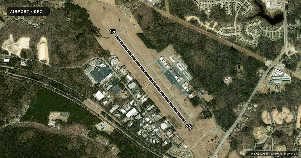
Airport sketch
Runways drawn to scale from FAA survey coordinates, rendered over satellite imagery. Not for navigation.
Approaches & charts
ILS · 1
Services on the field
Fuel grades, oxygen, maintenance, ramp storage and lighting — as declared to the FAA by the airport operator.
Fuel & services
- Fuel
- 100LLA
- Oxygen (bottled)
- High pressure
- Airframe repair
- Major
- Power plant repair
- Major
- Other services
- AFRT,CHTR,INSTR,RNTL,SALES,SURV
Ramp & ground
- Transient storage
- Tie-down
- Hangar
- Landing fee
- No fee published
- Customs
- Not available
- Lighting schedule
- SEE RMK
- Beacon schedule
- SS-SR
- Beacon
- White / Green (civil land)(WG)
- Wind indicator
- Lighted
- Segmented circle
- Yes
Fuel & FBOs
Cheapest 100LL and Jet A on the field and nearby. Always confirm with the FBO before taxi.
Airport notes
Surface conditions, obstructions, local procedures, lighting outages and other notes published with each FAA cycle.
General notes
- ACFT ON ILS APCH TO RICHMOND INTL CROSSING OVER ARPT.
- 400 FT TWR 5 NM N ARPT.
- NOISE SENSITIVE AREA NORTH OF ARPT. NO WIND VOLUNTARY USE OF RWY 15 PREFERRED.
- DEER & BIRDS ON & INVOF ARPT.
- HELICOPTER PARKING ADJ TO TWY C.
- MED-FLIGHT: IRREGULAR DEPARTURE PATTERN.
- ARFF EQPT AND TRAINED PERSONNEL AVBL AT ARPT.
- FOR CD CTC POTOMAC APCH AT 866-640-4124.
Lighting notes
- HIRL RWY 15/33 PRESET LOW INTST; INCR INTST & ACTVT MALSR RWY 33 & REIL RWY 15 - CTAF.
Fuel notes
- 100LLFUEL AFT HRS CALL 804-271-7793 OR 844-435-9732 BTN 2200-0700.
- AFUEL AFT HRS CALL 804-271-7793 OR 844-435-9732 BTN 2200-0700.
Other notes
- PRVDD A TFC PAT IS ESTAB BY THE CHIEF OF THE ATCT.
- ARFF INDEX A.
- TPA SINGLE ENGINE ACFT (1000 FT AGL) MULTI ENGINE ACFT (1500 FT AGL).
- OWNERBOARD OF SUPERVISORS.
VFR map & nearby airports
VFR sectional. Tap any ICAO chip to open that airport.
Key facts · KFCI
Answer card- ICAO
- KFCI
- Name
- RICHMOND EXEC/CHESTERFIELD COUNTY
- Location
- RICHMOND, VIRGINIA
- Elevation
- 236.1 ft MSL
- Traffic pattern altitude
- 1,236.1 ft MSL (1,000 AGL)
- Control tower
- Non-towered (use CTAF)
- Total runways
- 1
- Longest runway
- 15/33 · 5,500 ft
- Published ILS approaches
- 1
- Published frequencies
- 7
- Magnetic variation
- 10°
- Current flight rules
- VFR
- Current wind
- 040° at 3 kt
- Favored runway now
- RWY 33
Richmond Exec/Chesterfield County Airport (KFCI) sits in Richmond, Virginia at 236.1 ft MSL. It has one runway, 15/33, which is 5,500 ft long and paved with asphalt. The field is not towered. Pattern altitude is not published in the facts block, so use the standard 1,000 ft AGL for light piston traffic and verify the current pattern setup before arrival. One ILS is published for runway 33. Potomac Approach handles the listed approach and departure frequencies. For clearance delivery, the published remark directs pilots to Potomac Approach.
Vantage Aviation is the on-field FBO. It carries 100LL and Jet A Prist. After-hours fuel is available by phone contact, with the published numbers for the field. The remarks also note that runway lights on 15/33 are preset to low intensity. Pilots can increase intensity and activate the approach lighting system on runway 33 through the CTAF. Deer and birds are reported on and near the airport. Medical flight operations can use irregular departure patterns. The published pattern altitude is 1,000 ft AGL for single-engine aircraft and 1,500 ft AGL for multi-engine aircraft. Helicopter parking is adjacent to taxiway C. If you are planning an instrument arrival, remember that aircraft on the ILS to Richmond International cross over the airport.