METAR & TAF W96
Current METAR
Observed 13:35Z
KW96 271335Z AUTO 30004KT 10SM SCT009 24/21 A2987 RMK AO1 T02360207
- Wind
- 300° @ 4 kt
- Visibility
- 10 SM
- Temp / Dew
- 24°C / 21°C
- Altimeter
- 29.87 inHg
- Clouds
- SCT
- Density alt
- 1,292 ft
- Ceiling
- Unlimited
- Rules
- VFR
Airport info & contacts
Manager on record, flight service, ARTCC, attendance schedule and pattern altitude — published by the FAA and refreshed every 28 days.
Location
- From city
- 8 NM W
- VFR sectional
- WASHINGTON
- Pattern altitude
- 800 ft AGL · 921 ft MSL
- ARTCC
- ZDC · WASHINGTON
- NOTAM facility
- DCA (NOTAM-D)
Airport manager
- Name
- RUSS PEADEN
- Phone
- 804-932-3984
- Address
- 6901 TERMINAL RD, QUINTON VA 23141-2427
Flight service · Hours
- FSS DCA
- LEESBURG1-800-WX-BRIEF
- Attendance
- 0900-1700
Frequencies
Tap any row to copy the frequency to your clipboard.
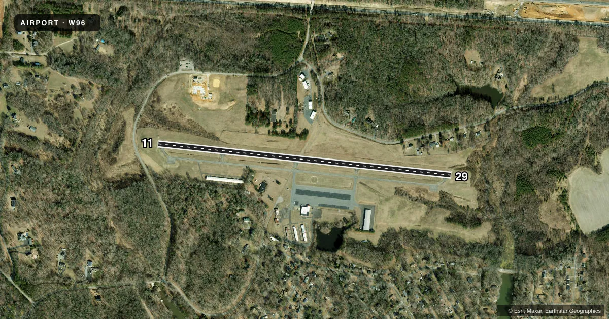
Runways & pattern
Full pagePattern entry · RWY 29
LEFT TRAFFICRunway end performance
| End | TORA | TODA | ASDA | LDA | VGSI | Approach lights | Obstruction |
|---|---|---|---|---|---|---|---|
| 11 | — | — | — | — | PAPI 2-box right(4°) | — | 5', road, 258' from thr, 9' R of cntrln, slope 11 |
| 29 | — | — | — | — | PAPI 2-box left(4°) | — | 20', trees, 438' from thr, 165' R of cntrln, slope 11 |
Declared distances in feet. TORA = takeoff run available, TODA = takeoff distance, ASDA = accelerate-stop, LDA = landing distance.
Airport sketch
Runways drawn to scale from FAA survey coordinates, rendered over satellite imagery. Not for navigation.
Approaches & charts
Services on the field
Fuel grades, oxygen, maintenance, ramp storage and lighting — as declared to the FAA by the airport operator.
Fuel & services
- Fuel
- 100LL
- Oxygen (bottled)
- Not available
- Oxygen (bulk)
- Not available
- Airframe repair
- Minor
- Power plant repair
- Minor
Ramp & ground
- Transient storage
- Tie-down
- Hangar
- Landing fee
- No fee published
- Customs
- Not available
- Lighting schedule
- SEE RMK
- Beacon schedule
- SS-SR
- Beacon
- White / Green (civil land)(WG)
- Wind indicator
- Lighted
- Segmented circle
- Yes
Fuel & FBOs
Cheapest 100LL and Jet A on the field and nearby. Always confirm with the FBO before taxi.
Airport notes
Surface conditions, obstructions, local procedures, lighting outages and other notes published with each FAA cycle.
General notes
- DEER ON & INVOF ARPT.
- FOR CD CTC POTOMAC APCH AT 866-640-4124.
Lighting notes
- ROTG BCN NOT VISIBLE WHEN APPROACHING FM THE NORTH.
- ACTVT REIL RWY 11 & 29; MIRL RWY 11/29 - CTAF.
Fuel notes
- 100LLFUEL AVBL 24 HRS, CREDIT CARD REQUIRED WHEN UNATTENDED.
Approach & departure obstructions
- 11RWY 11 - ROADWAY +15 FT 260 FT FM RWY END.
- 2913 FT BRUSH, 101 FT RIGHT OF CTRLN ON APCH AT THLD.
VFR map & nearby airports
VFR sectional. Tap any ICAO chip to open that airport.
Key facts · W96
Answer card- ICAO
- W96
- Name
- NEW KENT COUNTY
- Location
- QUINTON, VIRGINIA
- Elevation
- 120.7 ft MSL
- Traffic pattern altitude
- 920.7 ft MSL (800 AGL)
- Control tower
- Non-towered (use CTAF)
- Total runways
- 1
- Longest runway
- 11/29 · 3,602 ft
- Published ILS approaches
- 0
- Published frequencies
- 4
- Magnetic variation
- 10°
- Current flight rules
- VFR
- Current wind
- 300° at 4 kt
- Favored runway now
- RWY 29
New Kent County Airport sits in Quinton, Virginia. The field elevation is 120.7 ft MSL. It has one runway. Runway 11/29 is 3,602 ft long with an asphalt surface. There is no control tower. The pattern altitude is 800 ft AGL, which is 920.7 ft MSL. No ILS approaches are published here.
For traffic work, keep the published runway environment in mind. Runway 11 has a roadway 15 ft high located 260 ft from the runway end. Runway 29 has 13 ft brush 101 ft right of centerline on approach at the threshold. Deer are also on and in the vicinity of the airport. The rotating beacon is not visible when approaching from the north.
New Kent County Airport is served by the on-field FBO New Kent County Airport. It carries AVGAS 100LL. Fuel is available 24 hours. Credit card is required when unattended. Runway 11/29 has medium intensity runway lighting. REIL lighting is also published for both ends. Use CTAF for lighting activation. For clearance delivery, contact Potomac Approach. Pilots should also plan for the non-towered environment and verify current procedures in the FAA Chart Supplement before arrival.