METAR & TAF KFYJ
Current METAR
Observed 13:35Z
KFYJ 271335Z AUTO 00000KT 10SM CLR 24/21 A2987 RMK AO1 T02440207
- Wind
- 000° @ 0 kt
- Visibility
- 10 SM
- Temp / Dew
- 24°C / 21°C
- Altimeter
- 29.87 inHg
- Clouds
- CLR
- Density alt
- 1,167 ft
- Ceiling
- Unlimited
- Rules
- VFR
Airport info & contacts
Manager on record, flight service, ARTCC, attendance schedule and pattern altitude — published by the FAA and refreshed every 28 days.
Location
- From city
- 2 NM SE
- VFR sectional
- WASHINGTON
- ARTCC
- ZDC · WASHINGTON
- NOTAM facility
- FYJ (NOTAM-D)
Airport manager
- Name
- JOEL MOONEY
- Phone
- 804-785-9725
- Address
- 1000 AIRPORT RD, MATTAPONI VA 23110
Flight service · Hours
- FSS DCA
- LEESBURG1-800-WX-BRIEF
- Attendance
- 0800-1700
Frequencies
Tap any row to copy the frequency to your clipboard.
Runways & pattern
Full pagePattern entry · RWY 10
LEFT TRAFFICRunway end performance
| End | TORA | TODA | ASDA | LDA | VGSI | Approach lights | Obstruction |
|---|---|---|---|---|---|---|---|
| 10 | — | — | — | — | PAPI 2-box left(3.5°) | — | 10', tree, 302' from thr, 78' R of cntrln, slope 10 |
| 28 | — | — | — | — | PAPI 2-box left(3.5°) | — | 30', trees, 336' from thr, 137' R of cntrln, slope 4 |
Declared distances in feet. TORA = takeoff run available, TODA = takeoff distance, ASDA = accelerate-stop, LDA = landing distance.
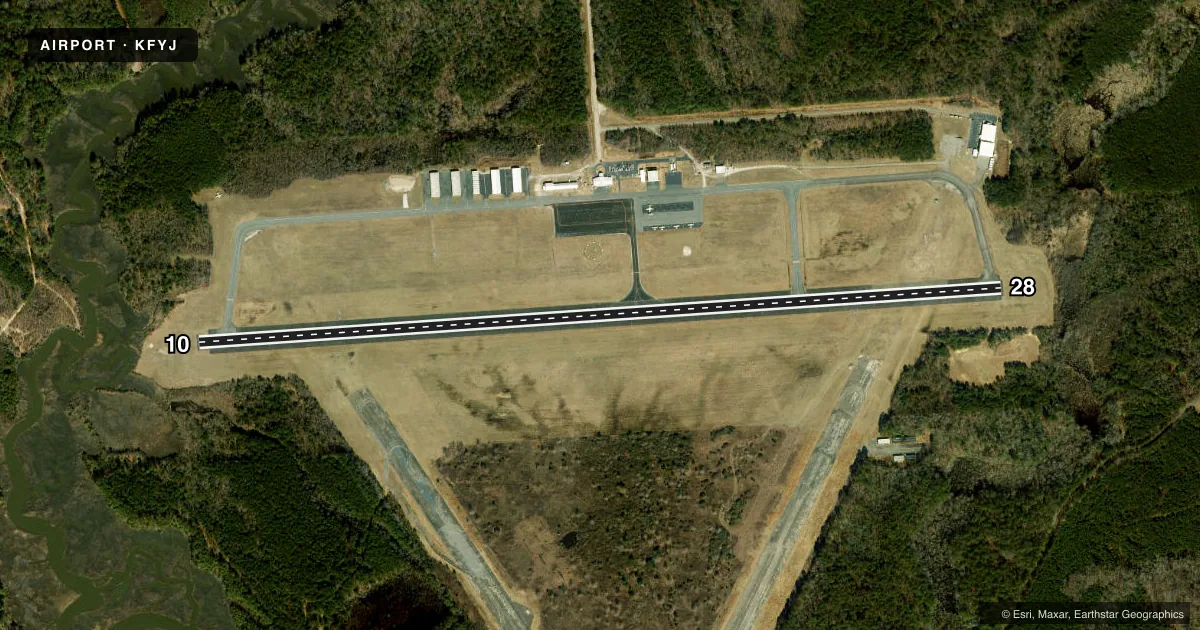
Airport sketch
Runways drawn to scale from FAA survey coordinates, rendered over satellite imagery. Not for navigation.
Approaches & charts
ILS · 1
Services on the field
Fuel grades, oxygen, maintenance, ramp storage and lighting — as declared to the FAA by the airport operator.
Fuel & services
- Fuel
- 100LLA+
- Oxygen (bottled)
- Not available
- Oxygen (bulk)
- Not available
- Airframe repair
- Major
- Power plant repair
- Major
- Other services
- AMB,INSTR,PAJA
Ramp & ground
- Transient storage
- Tie-down
- Landing fee
- No fee published
- Customs
- Not available
- Lighting schedule
- SEE RMK
- Beacon schedule
- SS-SR
- Beacon
- White / Green (civil land)(WG)
- Wind indicator
- Lighted
- Segmented circle
- Yes
Fuel & FBOs
Cheapest 100LL and Jet A on the field and nearby. Always confirm with the FBO before taxi.
Airport notes
Surface conditions, obstructions, local procedures, lighting outages and other notes published with each FAA cycle.
General notes
- DEER ON & INVOF ARPT.
- ROTOR-WING AND TILTROTOR ACFT FLY TFC PATS SOUTH OF RWY 10/28 AT 800 FT AGL OR ABV.
- FOR CD CTC NORFOLK APCH AT 757-464-0757.
Lighting notes
- REIL RWY 10 & 28; MIRL 10/28 OPR SS-SR. DRG DALGT HRS, PCL AVBL ON REQ, CTC AMGR. ACTVT REIL RWY 10 & 28; MIRL 10/28 - CTAF.
Fuel notes
- 100LLSELF SVC AVBL.
- A+FULL & SELF SVC AVBL.
Approach & departure obstructions
- 1023 FT TREE; 161 FT FM THR, 243 FT R OF CNTRLN.
- 10NON-STD MARKING PLACEMENT. MARKINGS NEED TO SHIFT 8 FT E OF CURRENT PLACEMENT.
Other notes
- IN OPERATION PRIOR 1959.
- TPA LGT ACFT 800 FT, HVY ACFT 1500 FT.
- MANAGERE-MAIL MANAGER@FLY-FYJ.COM.
- PAJAPAJA IRREGULAR.
VFR map & nearby airports
VFR sectional. Tap any ICAO chip to open that airport.
Key facts · KFYJ
Answer card- ICAO
- KFYJ
- Name
- MIDDLE PENINSULA RGNL
- Location
- WEST POINT, VIRGINIA
- Elevation
- 20.4 ft MSL
- Traffic pattern altitude
- 1,020.4 ft MSL (1,000 AGL)
- Control tower
- Non-towered (use CTAF)
- Total runways
- 1
- Longest runway
- 10/28 · 5,000 ft
- Published ILS approaches
- 1
- Published frequencies
- 6
- Magnetic variation
- 11°
- Current flight rules
- VFR
- Current wind
- 000° at 0 kt
- Favored runway now
- –
Middle Peninsula Regional Airport is in West Point, Virginia. The field elevation is 20.4 ft MSL. It has one runway, 10/28, which is 5,000 ft of asphalt. There is no control tower. The published ILS serves runway 10. Pattern altitude is not published, so use 1,000 ft AGL for light piston traffic unless ATC or the airport gives you different guidance. The remarks also note runway end identifier lights on 10 and 28. Medium intensity runway lights operate from sunset to sunrise. Pilot-controlled lighting is available in daylight by contacting the airport manager, with activation by CTAF.
Middle Peninsula Regional Airport is the on-field FBO. It carries 100LL, Jet A and A+ fuel. Self-service 100LL is available. Deer are reported on and near the airport. Keep a sharp scan on taxi, takeoff and landing. There is also a tree obstruction near runway 10. The published remarks say the runway 10 markings are not in standard placement. Rotor-wing and tiltrotor aircraft use traffic patterns south of runway 10/28 at 800 ft AGL or above. For clearance delivery, contact Norfolk Approach. If you need the airport manager, the published contact is manager@fly-fyj.com.