METAR & TAF W75
Current METAR
Observed 13:35Z
KW75 271335Z AUTO 32003KT 10SM SCT080 SCT085 SCT110 24/20 A2991 RMK AO1 T02390201
- Wind
- 320° @ 3 kt
- Visibility
- 10 SM
- Temp / Dew
- 24°C / 20°C
- Altimeter
- 29.91 inHg
- Clouds
- SCT
- Density alt
- 1,130 ft
- Ceiling
- Unlimited
- Rules
- VFR
Airport info & contacts
Manager on record, flight service, ARTCC, attendance schedule and pattern altitude — published by the FAA and refreshed every 28 days.
Location
- From city
- 6 NM E
- VFR sectional
- WASHINGTON
- ARTCC
- ZDC · WASHINGTON
- NOTAM facility
- DCA (NOTAM-D)
Airport manager
- Name
- RICHARD M LEWIS
- Phone
- 804-758-4330
- Address
- PO BOX 428, SALUDA VA 23149
Flight service · Hours
- FSS DCA
- LEESBURG1-800-WX-BRIEF
- Attendance
- 0800-1600
Frequencies
Tap any row to copy the frequency to your clipboard.
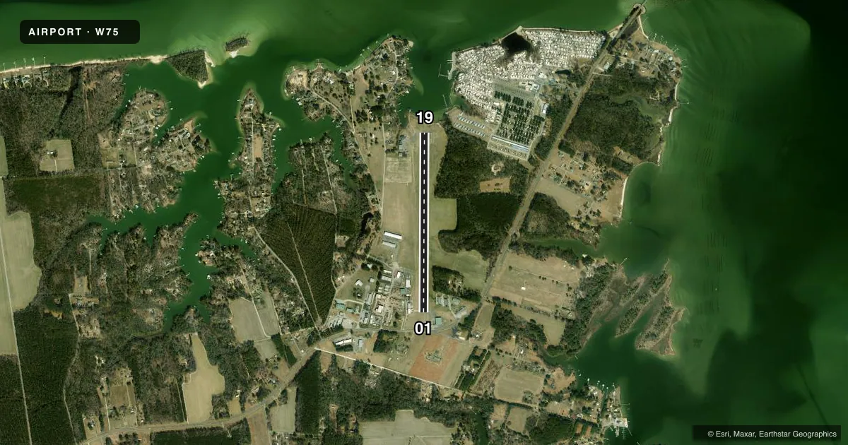
Runways & pattern
Full pagePattern entry · RWY 01
LEFT TRAFFICRunway end performance
| End | TORA | TODA | ASDA | LDA | VGSI | Approach lights | Obstruction |
|---|---|---|---|---|---|---|---|
| 01 | — | — | — | — | PAPI 2-box left(4°) | — | 92', tree, 1463' from thr, 173' R of cntrln, slope 13 |
| 19 | — | — | — | — | PAPI 2-box left(4°) | — | 67', tree, 1713' from thr, 178' R of cntrln, slope 22 |
Declared distances in feet. TORA = takeoff run available, TODA = takeoff distance, ASDA = accelerate-stop, LDA = landing distance.
Airport sketch
Runways drawn to scale from FAA survey coordinates, rendered over satellite imagery. Not for navigation.
Approaches & charts
Services on the field
Fuel grades, oxygen, maintenance, ramp storage and lighting — as declared to the FAA by the airport operator.
Fuel & services
- Fuel
- 100LL
- Oxygen (bottled)
- Not available
- Oxygen (bulk)
- Not available
- Airframe repair
- Major
- Power plant repair
- Major
- Other services
- AGRI,INSTR,RNTL
Ramp & ground
- Transient storage
- Tie-down
- Lighting schedule
- SEE RMK
- Beacon schedule
- SS-SR
- Beacon
- White / Green (civil land)(WG)
- Wind indicator
- Lighted
- Segmented circle
- No
Fuel & FBOs
Cheapest 100LL and Jet A on the field and nearby. Always confirm with the FBO before taxi.
Airport notes
Surface conditions, obstructions, local procedures, lighting outages and other notes published with each FAA cycle.
General notes
- DRAINAGE SWALES FULL LENGTH OF RY ON BOTH SIDES; USE OF EXIT IN FRONT OF HUMMEL AVIATION ADVISED.
- DEP RWY 01/19: CLIMB TO 500 FT BEFORE ANY TURN OUT; ARR ACFT USE WIDE PAT TO AVOID POPULATED AREAS EAST & WEST OF ARPT.
- BIRDS AND DEER ON & INVOF ARPT DURING WINTER.
- FOR CD CTC NORFOLK APCH AT 757-464-0757.
Lighting notes
- ACTVT MIRL RWY 01/19 - CTAF. PAPI RWY 01 & 19 OPS CONSLY.
Approach & departure obstructions
- 0118 FT BUILDING LOCATED 200 FT FM PAVEMENT END, 204 FT RIGHT OF CENTERLINE.
- 19FIELD IMMEDIATELY NORTH OF RWY 19. 7 FT CORN GROWING AT TIMES.
- 01ROAD RUNS PERPENDICULAR TO RWY END.
Other notes
- TOPPING IS THE CITY CLOSEST TO THE APT. APT IS 2 MILES ENE.
- 2UNATNDD THANKSGIVING, CHRISTMAS DAY AND NEW YEAR'S.
- MANAGERAPT PHYSICAL ADDRESS IS: 310 PLANEVIEW ROAD TOPPING, VA 23169
VFR map & nearby airports
VFR sectional. Tap any ICAO chip to open that airport.
Key facts · W75
Answer card- ICAO
- W75
- Name
- HUMMEL FLD
- Location
- SALUDA, VIRGINIA
- Elevation
- 30 ft MSL
- Traffic pattern altitude
- 1,030 ft MSL (1,000 AGL)
- Control tower
- Non-towered (use CTAF)
- Total runways
- 1
- Longest runway
- 01/19 · 3,150 ft
- Published ILS approaches
- 0
- Published frequencies
- 4
- Magnetic variation
- 10°
- Current flight rules
- VFR
- Current wind
- 320° at 3 kt
- Favored runway now
- RWY 01
Hummel Field is in Saluda, Virginia. The field elevation is 30 ft MSL. It has one runway, 01/19, which is 3,150 ft long and asphalt. There is no control tower. No ILS approaches are published. Pattern altitude is not published, so use the standard 1,000 ft AGL for light piston traffic unless the current Chart Supplement says otherwise.
Hummel Field is unattended on Thanksgiving, Christmas Day and New Year's. Hummel Field is on the field and carries AVGAS 100LL. Call (804) 758-4330 before arrival if you need fuel or local field info. The runway lights on 01/19 are activated by CTAF. The PAPI on both ends operates continuously. For clearance delivery, Norfolk Approach can be reached at 757-464-0757.
A few field details matter here. There is an 18-foot building near the departure end of runway 01. A road runs perpendicular to that same end. Birds and deer have been reported in the area during winter. Departing runway 01 or 19, climb to 500 feet before any turn out. Arriving aircraft should use a wide pattern to avoid the populated areas east and west of the airport. Drainage swales run the full length of the runway on both sides, so pay attention during rollout and taxi. The airport sits about 2 miles east-northeast of Topping.