METAR & TAF KMFV
Current METAR
Observed 05:35Z
KMFV 270535Z AUTO 17004KT 10SM BKN110 19/17 A2988 RMK AO2 LTG DSNT NE T01930173
- Wind
- 170° @ 4 kt
- Visibility
- 10 SM
- Temp / Dew
- 19°C / 17°C
- Altimeter
- 29.88 inHg
- Clouds
- BKN
- Density alt
- 589 ft
- Ceiling
- 11,000 ft AGL
- Rules
- VFR
Airport info & contacts
Manager on record, flight service, ARTCC, attendance schedule and pattern altitude — published by the FAA and refreshed every 28 days.
Location
- From city
- 1 NM W
- VFR sectional
- WASHINGTON
- ARTCC
- ZDC · WASHINGTON
- NOTAM facility
- MFV (NOTAM-D)
Airport manager
- Name
- BRUCE HERBERT
- Phone
- 757-787-4600
- Address
- 29194 PARKWAY NORTH, MELFA VA 23410
Flight service · Hours
- FSS DCA
- LEESBURG1-800-WX-BRIEF
- Attendance
- 0830-1730
Frequencies
Tap any row to copy the frequency to your clipboard.
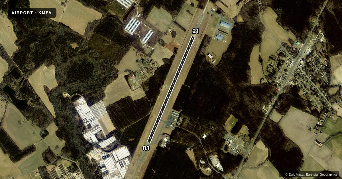
Runways & pattern
Full pagePattern entry · RWY 21
LEFT TRAFFICRunway end performance
| End | TORA | TODA | ASDA | LDA | VGSI | Approach lights | Obstruction |
|---|---|---|---|---|---|---|---|
| 03 | — | — | — | — | PAPI 2-box left(3°) | — | 74', tree, 2570' from thr, 229' R of cntrln, slope 32 |
| 21 | — | — | — | — | PAPI 2-box left(3°) | — | 94', tree, 1747' from thr, 318' R of cntrln, slope 16 |
Declared distances in feet. TORA = takeoff run available, TODA = takeoff distance, ASDA = accelerate-stop, LDA = landing distance.
Airport sketch
Runways drawn to scale from FAA survey coordinates, rendered over satellite imagery. Not for navigation.
Approaches & charts
ILS · 1
Services on the field
Fuel grades, oxygen, maintenance, ramp storage and lighting — as declared to the FAA by the airport operator.
Fuel & services
- Fuel
- 100LLA
- Oxygen (bottled)
- Not available
- Oxygen (bulk)
- Not available
- Airframe repair
- Not available
- Power plant repair
- Not available
- Other services
- AGRI,CHTR
Ramp & ground
- Transient storage
- Tie-down
- Landing fee
- No fee published
- Customs
- Not available
- Lighting schedule
- SEE RMK
- Beacon schedule
- SS-SR
- Beacon
- White / Green (civil land)(WG)
- Wind indicator
- Lighted
- Segmented circle
- Yes
Fuel & FBOs
Cheapest 100LL and Jet A on the field and nearby. Always confirm with the FBO before taxi.
Airport notes
Surface conditions, obstructions, local procedures, lighting outages and other notes published with each FAA cycle.
General notes
- DEER ON & INVOF ARPT.
- FOR CD CTC PATUXENT APCH AT 301-342-3740, WHEN PATUXENT APCH IS CLSD CTC POTOMAC APCH AT 866-640-4124.
Lighting notes
- MIRL RWY 03/21 PRESET LOW INTST; INCR INTST & ACTVT REIL RWYS 03 & 21 - CTAF.
Fuel notes
- 100LLSELF-SERVE FUEL (100LL AND A) AVBL 24HRS.
Other notes
- IN OPERATION PRIOR 1959.
- SUBJECT TO EXCLUSIVE RIGHTS PROHIBITION OF SECTION 308A (CONSTRUCTED BY BPR).
- TPA LGT ACFT 850 FT, HVY ACFT 1500 FT.
- 3AFT HRS ACES TO RESTROOMS.
VFR map & nearby airports
VFR sectional. Tap any ICAO chip to open that airport.
Key facts · KMFV
Answer card- ICAO
- KMFV
- Name
- ACCOMACK COUNTY
- Location
- MELFA, VIRGINIA
- Elevation
- 47.6 ft MSL
- Traffic pattern altitude
- 1,047.6 ft MSL (1,000 AGL)
- Control tower
- Non-towered (use CTAF)
- Total runways
- 1
- Longest runway
- 03/21 · 5,000 ft
- Published ILS approaches
- 1
- Published frequencies
- 6
- Magnetic variation
- 11°
- Current flight rules
- VFR
- Current wind
- 170° at 4 kt
- Favored runway now
- RWY 21
Accomack County Airport sits in Melfa, Virginia. Field elevation is 47.6 ft MSL. The airport has one runway, 03/21, at 5,000 ft. There is no control tower. Traffic pattern altitude is published at 850 ft AGL for light aircraft. That puts the light pattern at 897.6 ft MSL.
KMFV has one ILS approach to runway 03. The field uses CTAF 122.8 and UNICOM 122.8. Clearance delivery goes through Patuxent Approach. If Patuxent is closed, use Potomac Approach. The airport is on the coast side of Virginia’s Eastern Shore, so expect a flat environment with little terrain. Deer are reported on and near the airport. Keep a sharp scan on taxi, takeoff and landing.
Accomack County Airport is on the field and carries 100LL and Jet A. Self-serve fuel for both grades is available 24 hours. After-hours restroom access is also available. Runway lights on 03/21 are preset to low intensity. Use CTAF to increase intensity and to activate the runway end identifier lights. Pilots should also note the field’s published pattern altitude for heavy aircraft is 1,500 ft AGL.