METAR & TAF KTGI
Current METAR
Observed 07:35Z
KTGI 270735Z AUTO 16005KT 20/20 A3000 RMK AO1 T02030200
- Wind
- 160° @ 5 kt
- Visibility
- —
- Temp / Dew
- 20°C / 20°C
- Altimeter
- 30.00 inHg
- Clouds
- Clear
- Density alt
- 507 ft
- Ceiling
- Unlimited
- Rules
- VFR
Airport info & contacts
Manager on record, flight service, ARTCC, attendance schedule and pattern altitude — published by the FAA and refreshed every 28 days.
Location
- From city
- 1 NM W
- VFR sectional
- WASHINGTON
- ARTCC
- ZDC · WASHINGTON
- NOTAM facility
- DCA (NOTAM-D)
Airport manager
- Name
- LAURIE THOMAS
- Phone
- 757-891-2496
- Address
- PO BOX 244, TANGIER VA 23440
Flight service · Hours
- FSS DCA
- LEESBURG1-800-WX-BRIEF
- Attendance
- APR-OCT · SAT-SUN · 0800-1630
Frequencies
Tap any row to copy the frequency to your clipboard.
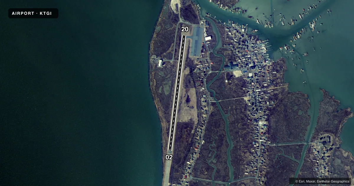
Runways & pattern
Full pagePattern entry · RWY 20
LEFT TRAFFICRunway end performance
| End | TORA | TODA | ASDA | LDA | VGSI | Approach lights | Obstruction |
|---|---|---|---|---|---|---|---|
| 02 | — | — | — | — | — | — | 12', tree, 219' from thr, 91' R of cntrln, slope 1 |
| 20 | — | — | — | — | — | — | 15', road, 249' from thr, 0' R of cntrln, slope 3 |
Declared distances in feet. TORA = takeoff run available, TODA = takeoff distance, ASDA = accelerate-stop, LDA = landing distance.
Airport sketch
Runways drawn to scale from FAA survey coordinates, rendered over satellite imagery. Not for navigation.
Approaches & charts
Services on the field
Fuel grades, oxygen, maintenance, ramp storage and lighting — as declared to the FAA by the airport operator.
Fuel & services
- Fuel
- Not available
- Oxygen (bottled)
- Not available
- Oxygen (bulk)
- Not available
- Airframe repair
- Not available
- Power plant repair
- Not available
Ramp & ground
- Transient storage
- Tie-down
- Landing fee
- Yes
- Customs
- Not available
- Beacon
- White / Green (civil land)(WG)
- Wind indicator
- Yes
- Segmented circle
- No
Fuel & FBOs
Cheapest 100LL and Jet A on the field and nearby. Always confirm with the FBO before taxi.
Airport notes
Surface conditions, obstructions, local procedures, lighting outages and other notes published with each FAA cycle.
General notes
- PAEW ADJACENT TO ALL RWYS, TWYS & RAMPS.
- BE ALERT: RSTD AREA ONE MI WEST OF ARPT; HI-SPEED ACFT DROP BOMBS & FIRE LIVE AMMUNITION IN AREA.
- LANDING/PARKING FEE TO HELP PAY FOR RECENT RWY REHAB.
- FOR CD CTC PATUXENT APCH AT 301-342-3740, WHEN PATUXENT APCH IS CLSD CTC POTOMAC APCH AT 866-640-4124.
Lighting notes
- ARPT BCN OTS INDEFLY.
Approach & departure obstructions
- 02BRUSH 70 FT LEFT & RIGHT RWY CNTRLN.
- 20BRUSH 70 FT RIGHT & LEFT RWY CNTRLN.
- 02PREV RWY NRS VSB ON FORMER RWY PAVEMENT. CHEVRONS ON FORMER RWY PAVEMENT POOR. RWY CENTERLINE POOR.
- 20TWY LEAD-IN LINES POOR. RWY CENTERLINE POOR.
- 02CLNC SLP 15:1 TO DTHR.
Other notes
- <TPA LGT ACFT 600 FT HVY ACFT 1500 FT.
- 1ARPT CLSD SS-SR DLY.
- OWNERTOWN OFFICE (757) 891-2438.
VFR map & nearby airports
VFR sectional. Tap any ICAO chip to open that airport.
Key facts · KTGI
Answer card- ICAO
- KTGI
- Name
- TANGIER ISLAND
- Location
- TANGIER, VIRGINIA
- Elevation
- 5.4 ft MSL
- Traffic pattern altitude
- 1,005.4 ft MSL (1,000 AGL)
- Control tower
- Non-towered (use CTAF)
- Total runways
- 1
- Longest runway
- 02/20 · 2,426 ft
- Published ILS approaches
- 0
- Published frequencies
- 6
- Magnetic variation
- 11°
- Current flight rules
- VFR
- Current wind
- 160° at 5 kt
- Favored runway now
- RWY 20
Tangier Island Airport sits in Tangier, Virginia. Field elevation is 5.4 ft MSL. The airport has one runway, 02/20, which is 2,426 ft long with asphalt pavement. There is no control tower. No ILS approaches are published. Pattern altitude for light aircraft is 600 ft AGL, which puts you at about 605 ft MSL on the published pattern.
This is a small island field with some operational wrinkles. The airport is closed from sunset to sunrise daily. The beacon is out of service indefinitely. Published remarks also call out poor runway centerline markings and poor taxiway lead-in lines. Power lines are adjacent to all runways, taxiways and ramps. Brush is reported 70 feet right and left of the runway centerline on runway 20. There is also a restricted area about 1 mile west of the airport. Stay alert for military activity in the area.
No on-field FBOs are listed in the facts. Contact the airport operator directly before arrival if you need local services. Clearance delivery goes through Patuxent Approach at 301-342-3740. When Patuxent Approach is closed, use Potomac Approach at 866-640-4124. The published remarks also note a landing and parking fee tied to runway rehabilitation. Verify current details with the airport operator before you go.