METAR & TAF KAOO
Current METAR
Observed 16:53Z
KAOO 271653Z AUTO 34007KT 10SM FEW036 27/18 A2991 RMK AO2 SLPNO T02670183
- Wind
- 340° @ 7 kt
- Visibility
- 10 SM
- Temp / Dew
- 27°C / 18°C
- Altimeter
- 29.91 inHg
- Clouds
- FEW
- Density alt
- 3,317 ft
- Ceiling
- Unlimited
- Rules
- VFR
Airport info & contacts
Manager on record, flight service, ARTCC, attendance schedule and pattern altitude — published by the FAA and refreshed every 28 days.
Location
- From city
- 12 NM S
- VFR sectional
- DETROIT
- ARTCC
- ZOB · CLEVELAND
- NOTAM facility
- AOO (NOTAM-D)
Airport manager
- Name
- TRACY PLESSINGER
- Phone
- 814-793-2027
- Address
- 310 AIRPORT DRIVE, SUITE 6, MARTINSBURG PA 16662
Flight service · Hours
- FSS AOO
- ALTOONA1-800-WX-BRIEF
- Attendance
- MON-FRI · 0430-2230
- SAT · 0730-1930
- SUN · 0830-2030
Frequencies
Tap any row to copy the frequency to your clipboard.
Runways & pattern
Full pagePattern entry · RWY 03
LEFT TRAFFIC| Runway | Heading (°M) | Length | Surface | Traffic |
|---|---|---|---|---|
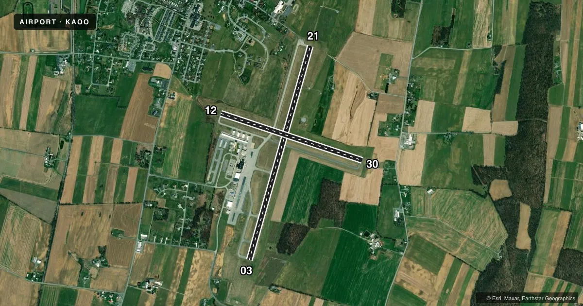
| 03/21Favored | 6° / 186° | 5,465 ft | ASPH | Standard L |
| 12/30 | 98° / 278° | 3,668 ft | ASPH | Standard L |
Runway end performance
| End | TORA | TODA | ASDA | LDA | VGSI | Approach lights | Obstruction |
|---|---|---|---|---|---|---|---|
| 03 | 5,465' | 5,465' | 5,465' | 5,465' | PAPI 4-box left(3°) | — | 46', trees, 886' from thr, 522' R of cntrln, slope 14 |
| 21 | 5,465' | 5,465' | 5,465' | 5,465' | PAPI 4-box left(3°) | MALSR | 72', tree, 1950' from thr, 685' R of cntrln, slope 24 |
| 12 | 3,668' | 3,668' | 3,668' | 3,668' | PAPI 4-box left(3°) | — | 7', tree, 260' from thr, 82' R of cntrln, slope 8 |
| 30 | 3,668' | 3,668' | 3,668' | 3,668' | PAPI 4-box right(4°) | — | 15', trees, 397' from thr, 59' R of cntrln, slope 13 |
Declared distances in feet. TORA = takeoff run available, TODA = takeoff distance, ASDA = accelerate-stop, LDA = landing distance.
Airport sketch
Runways drawn to scale from FAA survey coordinates, rendered over satellite imagery. Not for navigation.
Approaches & charts
ILS · 1
Services on the field
Fuel grades, oxygen, maintenance, ramp storage and lighting — as declared to the FAA by the airport operator.
Fuel & services
- Fuel
- 100LLA
- Oxygen (bottled)
- High pressure
- Oxygen (bulk)
- High pressure
- Airframe repair
- Major
- Power plant repair
- Major
- Other services
- AVNCS,CARGO,CHTR,INSTR,RNTL,SALES
Ramp & ground
- Transient storage
- Tie-down
- Hangar
- Landing fee
- No fee published
- Customs
- Not available
- Lighting schedule
- SEE RMK
- Beacon schedule
- SS-SR
- Beacon
- White / Green (civil land)(WG)
- Wind indicator
- Lighted
- Segmented circle
- Yes
Fuel & FBOs
Cheapest 100LL and Jet A on the field and nearby. Always confirm with the FBO before taxi.
Airport notes
Surface conditions, obstructions, local procedures, lighting outages and other notes published with each FAA cycle.
General notes
- PREFERRED RWY IS RWY 21; FOR NOISE ABATEMENT WHEN DEP RWY 03 MAINT RWY HDG TIL 2 NM N OF ARPT.
- SPECIALIZED ACFT (ULTRALGT, HOMEBUILT, ETC) CTC AMGR 814-793-2027 OR UNICOM PRIOR TO LDG.
- RWY/TWY CONDITIONS UNMONITORED OUTSIDE OF NML ATTENDANCE HRS.
- FOR CD CTC JOHNSTOWN APCH AT 814-532-5960, WHEN APCH CLSD CTC CLEVELAND ARTCC AT 440-774-0213.
Lighting notes
- HIRL RY 03/21 & MIRL RY 12/30 PRESET LOW INTST, INCR INTST & ACTVT PAPI RYS 12, 30, 03 & 21, MALSR RY 21 & REIL RYS 03, 12, & 30 - CTAF.
Runway surface & condition
- 03/21PCR VALUE: 321/F/D/X/T
- 12/30RWY 12/30 NOT AVBL FOR PART 121/PART 380 OPS WITH SKED PAX CARRYING OPS MORE THAN 9 PAX SEATS AND NON-SKED PAX CARRYING OPS MORE THAN 30 PAX SEATS. NO PART 121/PART 380 OPS EXC FOR TAX.
- 03/21RY 03/21, THRESHOLD LGTS & EDGE LGTS OTS EXCEPT WITH PCL, AVBL FM 0100-1300Z DAILY.
- 12/30RY 12/30, THRESHOLD LGTS & EDGE LGTS OTS EXCEPT WITH PCL, AVBL FM 0100-1300Z DAILY.
Approach & departure obstructions
- 30HAS + 4 FT GND 20 FT FM RY END 215 FT RIGHT.
Other notes
- PPR 24 FOR UNSKED ACR & NON-ACR OPNS WITH MORE THAN 30 PSGR SEATS; CALL AMGR 814-793-2027.
VFR map & nearby airports
VFR sectional. Tap any ICAO chip to open that airport.
Key facts · KAOO
Answer card- ICAO
- KAOO
- Name
- ALTOONA/BLAIR COUNTY
- Location
- ALTOONA, PENNSYLVANIA
- Elevation
- 1,503.4 ft MSL
- Traffic pattern altitude
- 2,503.4 ft MSL (1,000 AGL)
- Control tower
- Non-towered (use CTAF)
- Total runways
- 2
- Longest runway
- 03/21 · 5,465 ft
- Published ILS approaches
- 1
- Published frequencies
- 3
- Magnetic variation
- 10°
- Current flight rules
- VFR
- Current wind
- 340° at 7 kt
- Favored runway now
- RWY 03
KAOO is in Altoona, Pennsylvania. The field elevation is 1,503.4 ft MSL. It has two asphalt runways. The longest is runway 03/21 at 5,465 ft. There is no control tower, so use CTAF 123.6 and coordinate with Johnstown Approach on the listed approach frequencies when needed.
One ILS is published for runway 21. Pattern altitude is not published, so plan on the standard 1,000 ft AGL for light piston traffic unless the current FAA Chart Supplement says otherwise. The airport sits in central Pennsylvania terrain, so pay attention to climb performance and arrival planning, especially on warm days.
Altoona Flight Services is on the field. It carries 100LL, Jet A and Jet A Prist. The published remarks also note that runway 21 is the preferred runway. For departures off runway 03, hold runway heading until 2 NM north of the airport for noise abatement. Runway 12/30 has lighting limits. Its threshold and edge lights are out of service except with pilot-controlled lighting from 0100 to 1300 Zulu daily. Runway 03/21 has the same pilot-controlled lighting window. Runway and taxiway conditions are not monitored outside normal attendance hours, so a quick call before arrival is smart.