METAR & TAF 9G8
9G8 does not publish a METAR.
Showing the nearest reporting station: KJST (JOHN MURTHA JOHNSTOWN/CAMBRIA COUNTY) · 9.2 NM away. Conditions at 9G8 may differ.
METAR · KJST
Observed 16:05Z
KJST 271605Z AUTO 29008KT 10SM FEW018 SCT022 BKN032 23/18 A2996 RMK AO2 T02280183
- Wind
- 290° @ 8 kt
- Visibility
- 10 SM
- Temp / Dew
- 23°C / 18°C
- Altimeter
- 29.96 inHg
- Clouds
- BKN
- Density alt
- 3,513 ft
- Ceiling
- 3,200 ft AGL
- Rules
- VFR
Airport info & contacts
Manager on record, flight service, ARTCC, attendance schedule and pattern altitude — published by the FAA and refreshed every 28 days.
Location
- From city
- 3 NM SW
- VFR sectional
- DETROIT
- ARTCC
- ZOB · CLEVELAND
- NOTAM facility
- AOO (NOTAM-D)
Airport manager
- Name
- BILL GRADY
- Phone
- 202-262-6593
- Address
- 3920 ADMIRAL PEARY HIGHWAY, EBENSBURG PA 15931
Flight service · Hours
- FSS AOO
- ALTOONA1-800-WX-BRIEF
- Attendance
- IREG
Frequencies
Tap any row to copy the frequency to your clipboard.
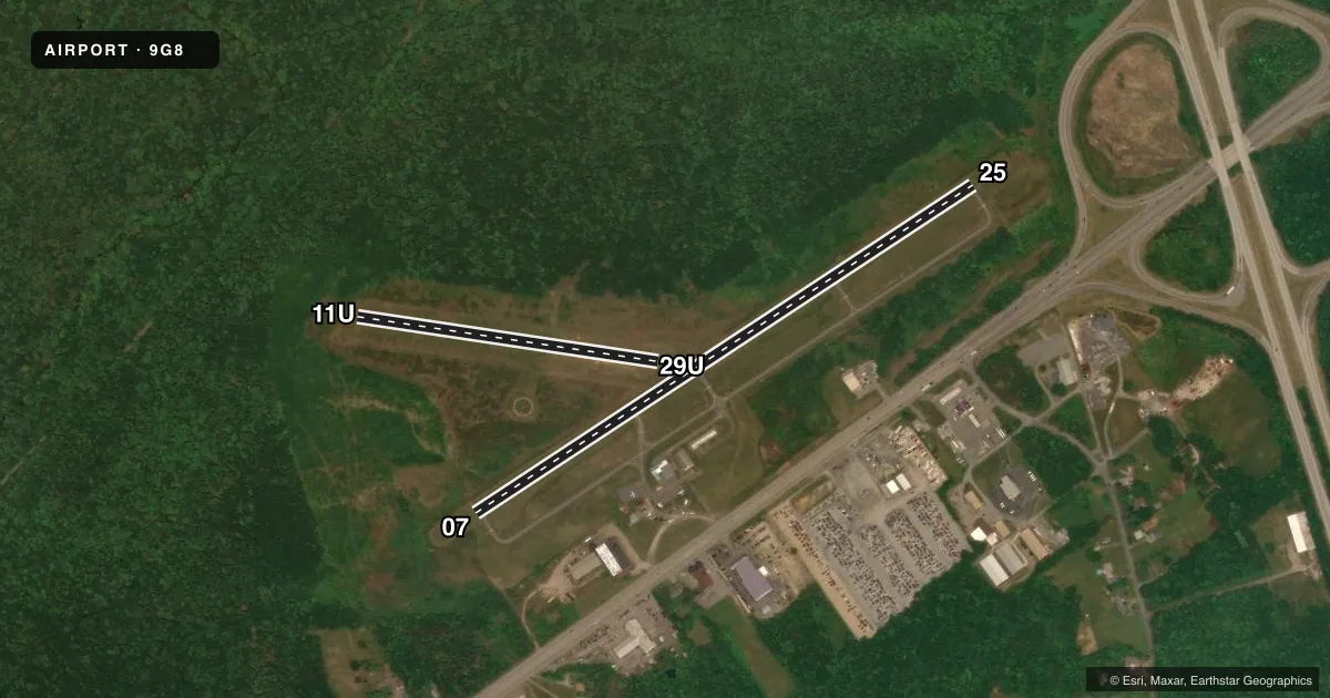
Runways & pattern
Full pagePattern entry · RWY 29U
LEFT TRAFFIC| Runway | Heading (°M) | Length | Surface | Traffic |
|---|---|---|---|---|
| 07/25 | 48° / 228° | 3,204 ft | ASPH | Standard L |
| 11U/29UFavored | 89° / 269° | 1,636 ft | TURF-DIRT | Standard L |
Runway end performance
| End | TORA | TODA | ASDA | LDA | VGSI | Approach lights | Obstruction |
|---|---|---|---|---|---|---|---|
| 07 | — | — | — | — | — | — | 55', trees, 900' from thr, 269' R of cntrln, slope 12 |
| 25 | — | — | — | — | — | — | 13', trees, 312' from thr, 134' R of cntrln, slope 8 |
| 29U | — | — | — | — | — | — | 52', tree, 678' from thr, 19' R of cntrln, slope 13 |
Declared distances in feet. TORA = takeoff run available, TODA = takeoff distance, ASDA = accelerate-stop, LDA = landing distance.
Airport sketch
Runways drawn to scale from FAA survey coordinates, rendered over satellite imagery. Not for navigation.
Approaches & charts
Services on the field
Fuel grades, oxygen, maintenance, ramp storage and lighting — as declared to the FAA by the airport operator.
Fuel & services
- Fuel
- 100LL
- Oxygen (bottled)
- Not available
- Oxygen (bulk)
- Not available
- Airframe repair
- Not available
- Power plant repair
- Not available
- Other services
- INSTR,RNTL
Ramp & ground
- Transient storage
- Tie-down
- Landing fee
- No fee published
- Customs
- Not available
- Lighting schedule
- SEE RMK
- Beacon schedule
- SS-SR
- Beacon
- White / Green (civil land)(WG)
- Wind indicator
- Lighted
- Segmented circle
- Yes
Fuel & FBOs
Cheapest 100LL and Jet A on the field and nearby. Always confirm with the FBO before taxi.
Airport notes
Surface conditions, obstructions, local procedures, lighting outages and other notes published with each FAA cycle.
General notes
- DEER ON & INVOF ARPT.
- FOR CD CTC JOHNSTOWN APCH AT 814-532-5960, WHEN APCH CLSD CTC CLEVELAND ARTCC AT 440-774-0213.
Lighting notes
- ACTVT MIRL RWY 07/25 & TWY LGTS - CTAF.
Fuel notes
- 100LL24 HR SELF-SERVE FUEL AVBL.
Runway surface & condition
- 11U/29URWY 11U/29U FOR ULTRALIGHT USE ONLY.
Approach & departure obstructions
- 07BSC RWY MARKINGS
- 25BSC RWY MARKINGS
- 11URWY 11U/29U RWY BOUNDARY MKD WITH YELLOW CONES.
Other notes
- 4 ON MAIN APRON 2 UNDER ROOF (OLD HANGAR WITHOUT SIDES)
VFR map & nearby airports
VFR sectional. Tap any ICAO chip to open that airport.
Key facts · 9G8
Answer card- ICAO
- 9G8
- Name
- EBENSBURG
- Location
- EBENSBURG, PENNSYLVANIA
- Elevation
- 2,099 ft MSL
- Traffic pattern altitude
- 3,099 ft MSL (1,000 AGL)
- Control tower
- Non-towered (use CTAF)
- Total runways
- 2
- Longest runway
- 07/25 · 3,204 ft
- Published ILS approaches
- 0
- Published frequencies
- 4
- Magnetic variation
- 9°
- Current flight rules
- VFR
- Current wind
- 290° at 8 kt
- Favored runway now
- RWY 29U
Ebensburg Airport sits in Ebensburg, Pennsylvania at 2,099 ft MSL. It has two runways. The longest is 07/25 at 3,204 ft of asphalt. Runway 11U/29U is 1,636 ft of turf-dirt and is for ultralight use only. There is no control tower. CTAF and UNICOM are both 122.8. Johnstown Approach handles clearance delivery and approach support on 121.2 and 299.2 when available.
No ILS approaches are published here. Pattern altitude is not published, so use the standard 1,000 ft AGL for light piston traffic unless the current Chart Supplement says otherwise. The field uses medium intensity runway lights on 07/25. Taxiway lights are activated on the common traffic advisory frequency. Basic runway markings are present on 07 and 25. Deer are reported on and near the airport. Keep a sharp scan on taxi, takeoff and landing.
Ebensburg Airport is the on-field FBO. It carries 100LL. Twenty-four hour self-serve 100LL is available. The airport also has four tie-downs on the main apron and two covered spots in the old hangar without sides. For clearance delivery, contact Johnstown Approach at 814-532-5960. When Johnstown Approach is closed, contact Cleveland ARTCC at 440-774-0213.