METAR & TAF KIDI
Current METAR
Observed 15:15Z
KIDI 271515Z AUTO VRB04KT 9SM OVC011 22/20 A2994 RMK A01
- Wind
- VAR @ 4 kt
- Visibility
- 9 SM
- Temp / Dew
- 22°C / 20°C
- Altimeter
- 29.94 inHg
- Clouds
- OVC
- Density alt
- 2,575 ft
- Ceiling
- 1,100 ft AGL
- Rules
- MVFR
Airport info & contacts
Manager on record, flight service, ARTCC, attendance schedule and pattern altitude — published by the FAA and refreshed every 28 days.
Location
- From city
- 2 NM E
- VFR sectional
- DETROIT
- ARTCC
- ZOB · CLEVELAND
- NOTAM facility
- IDI (NOTAM-D)
Airport manager
- Name
- RODGER EWING
- Phone
- 724-463-3883
- Address
- 398 AIRPORT ROAD, INDIANA PA 15701
Flight service · Hours
- FSS AOO
- ALTOONA1-800-WX-BRIEF
- Attendance
- MON-FRI · 0800-1600
Frequencies
Tap any row to copy the frequency to your clipboard.
Runways & pattern
Full pagePattern entry · RWY 29
LEFT TRAFFICRunway end performance
| End | TORA | TODA | ASDA | LDA | VGSI | Approach lights | Obstruction |
|---|---|---|---|---|---|---|---|
| 11 | — | — | — | — | PAPI 4-box left(3°) | — | 83', trees, 1485' from thr, 623' R of cntrln, slope 15 |
| 29 | — | — | — | — | PAPI 4-box left(3°) | — | 137', trees, 3158' from thr, 660' R of cntrln, slope 21 |
Declared distances in feet. TORA = takeoff run available, TODA = takeoff distance, ASDA = accelerate-stop, LDA = landing distance.
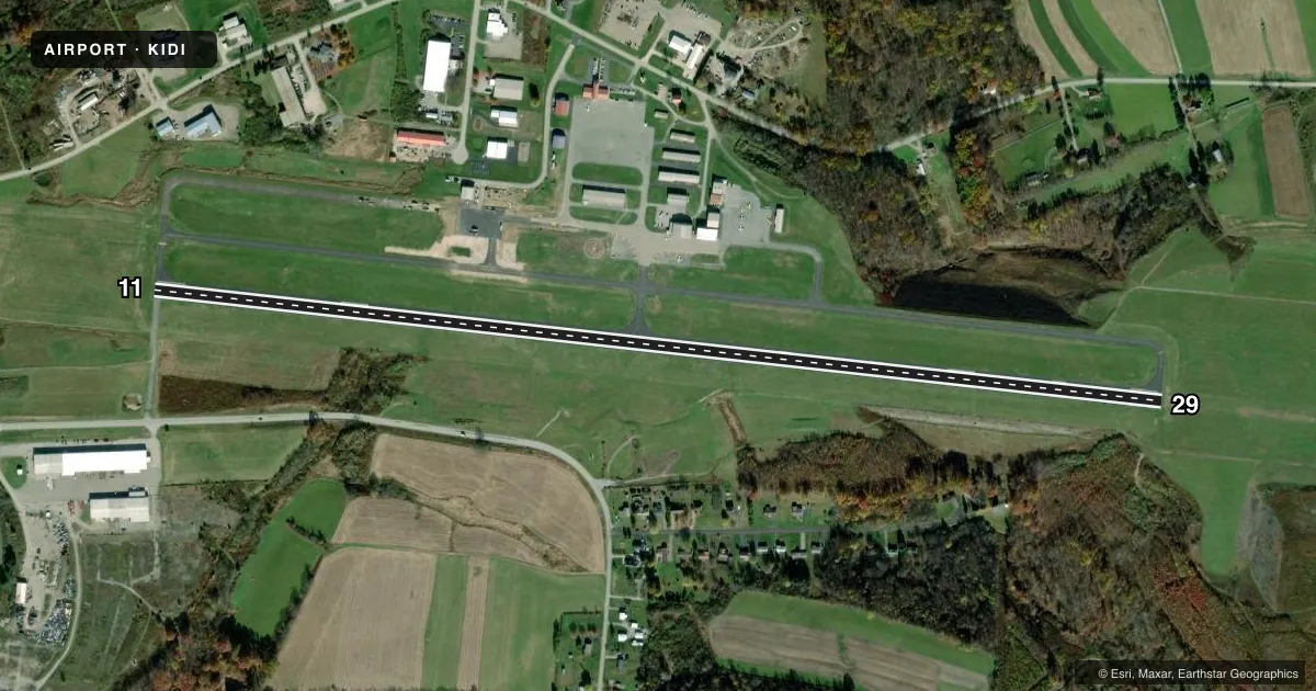
Airport sketch
Runways drawn to scale from FAA survey coordinates, rendered over satellite imagery. Not for navigation.
Approaches & charts
Services on the field
Fuel grades, oxygen, maintenance, ramp storage and lighting — as declared to the FAA by the airport operator.
Fuel & services
- Fuel
- 100LLAA+
- Oxygen (bottled)
- Not available
- Oxygen (bulk)
- Not available
- Airframe repair
- Minor
- Power plant repair
- Minor
- Other services
- AVNCS,INSTR,RNTL
Ramp & ground
- Transient storage
- Tie-down
- Hangar
- Landing fee
- Yes
- Customs
- Not available
- Lighting schedule
- SEE RMK
- Beacon schedule
- SS-SR
- Beacon
- White / Green (civil land)(WG)
- Wind indicator
- Lighted
- Segmented circle
- Yes
Fuel & FBOs
Cheapest 100LL and Jet A on the field and nearby. Always confirm with the FBO before taxi.
Airport notes
Surface conditions, obstructions, local procedures, lighting outages and other notes published with each FAA cycle.
General notes
- BIRDS & DEER ON & INVOF ARPT.
- FOR CD CTC JOHNSTOWN APCH AT 814-532-5960, WHEN APCH CLSD CTC CLEVELAND ARTCC AT 440-774-0213.
Lighting notes
- ACTVT REIL RWY 11; PAPI RWY 11 & 29; HIRL RWY 11/29 & TWYS - CTAF.
Fuel notes
- 100LL24 HR 100LL AVBL WITH CREDIT CARD.
Other notes
- LNDG FEE FOR FIXED WING TURBINE ACFT WAIVED WITH FUEL PURCHASE.
- 1ARPT ATNDNC AFTER HRS BY PRIOR ARNGMT. CLSD MAJOR HOL.
VFR map & nearby airports
VFR sectional. Tap any ICAO chip to open that airport.
Key facts · KIDI
Answer card- ICAO
- KIDI
- Name
- INDIANA COUNTY/JIMMY STEWART FLD
- Location
- INDIANA, PENNSYLVANIA
- Elevation
- 1,419.3 ft MSL
- Traffic pattern altitude
- 2,419.3 ft MSL (1,000 AGL)
- Control tower
- Non-towered (use CTAF)
- Total runways
- 1
- Longest runway
- 11/29 · 5,502 ft
- Published ILS approaches
- 0
- Published frequencies
- 4
- Magnetic variation
- 10°
- Current flight rules
- MVFR
- Current wind
- 000° at 4 kt
- Favored runway now
- RWY 29
Indiana County/Jimmy Stewart Fld sits in Indiana, Pennsylvania. The field elevation is 1,419.3 ft MSL. It has one runway. Runway 11/29 is 5,502 ft long with asphalt pavement. The airport is non-towered. CTAF and UNICOM are both 122.8. Johnstown Approach handles clearance delivery and approach services on 121.2 and 299.2 when available.
No ILS approaches are published here. Pattern altitude is not published in the facts. Use the standard 1,000 ft AGL for light piston operations unless the current Chart Supplement says otherwise. The published remarks also note that runway 11 has REILs. PAPI is on runways 11 and 29. High intensity runway lights are on the runway and taxiways. Use the common traffic advisory frequency.
Indiana County Airport is the on-field FBO. It carries 100LL, Jet A and Jet A Prist. Twenty-four hour 100LL is available with credit card. Airport attendance after hours is by prior arrangement. The airport is closed on major holidays. Birds and deer are reported on and near the field. Keep a sharp scan on arrival and departure. For turbine fixed-wing traffic, the landing fee is waived with a fuel purchase.