METAR & TAF KDUJ
Current METAR
Observed 13:32Z
KDUJ 271332Z AUTO 23005KT 9SM BKN014 20/18 A2993 RMK AO2 T02000183
- Wind
- 230° @ 5 kt
- Visibility
- 9 SM
- Temp / Dew
- 20°C / 18°C
- Altimeter
- 29.93 inHg
- Clouds
- BKN
- Density alt
- 2,840 ft
- Ceiling
- 1,400 ft AGL
- Rules
- MVFR
Airport info & contacts
Manager on record, flight service, ARTCC, attendance schedule and pattern altitude — published by the FAA and refreshed every 28 days.
Location
- From city
- 7 NM NW
- VFR sectional
- DETROIT
- ARTCC
- ZOB · CLEVELAND
- NOTAM facility
- DUJ (NOTAM-D)
Airport manager
- Name
- ROBERT W. SHAFFER
- Phone
- 814-328-5311
- Address
- 377 AVIATION WAY, REYNOLDSVILLE PA 15851
Flight service · Hours
- FSS AOO
- ALTOONA1-800-WX-BRIEF
- Attendance
- MON-FRI · 0500-0000
- SAT · 0500-1800
- SUN · 0800-0000
Frequencies
Tap any row to copy the frequency to your clipboard.
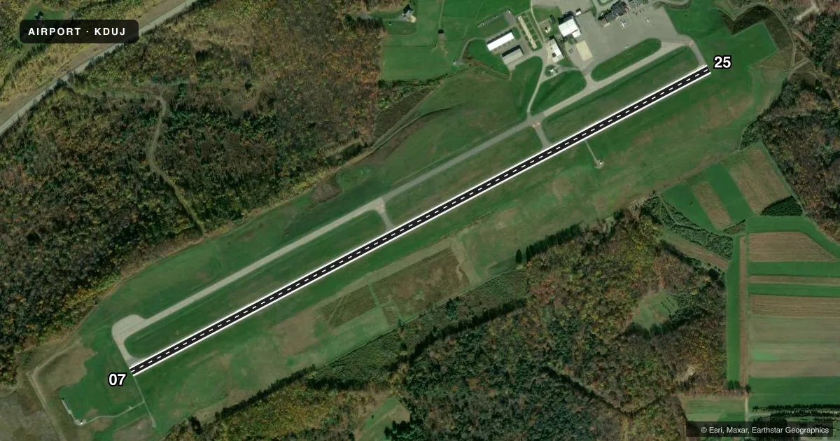
Runways & pattern
Full pagePattern entry · RWY 25
LEFT TRAFFICRunway end performance
| End | TORA | TODA | ASDA | LDA | VGSI | Approach lights | Obstruction |
|---|---|---|---|---|---|---|---|
| 07 | 5,503' | 5,503' | 5,503' | 5,503' | VASI 2-box left(3°) | — | — |
| 25 | 5,503' | 5,503' | 5,503' | 5,503' | PAPI 4-box left(3°) | MALSR | 48', trees, 1772' from thr, 706' R of cntrln, slope 32 |
Declared distances in feet. TORA = takeoff run available, TODA = takeoff distance, ASDA = accelerate-stop, LDA = landing distance.
Airport sketch
Runways drawn to scale from FAA survey coordinates, rendered over satellite imagery. Not for navigation.
Approaches & charts
ILS · 1
Services on the field
Fuel grades, oxygen, maintenance, ramp storage and lighting — as declared to the FAA by the airport operator.
Fuel & services
- Fuel
- 100LLA
- Oxygen (bottled)
- Not available
- Oxygen (bulk)
- Not available
- Airframe repair
- Not available
- Power plant repair
- Not available
Ramp & ground
- Transient storage
- Tie-down
- Customs
- Not available
- Lighting schedule
- SEE RMK
- Beacon schedule
- SS-SR
- Beacon
- White / Green (civil land)(WG)
- Wind indicator
- Lighted
- Segmented circle
- No
Fuel & FBOs
Cheapest 100LL and Jet A on the field and nearby. Always confirm with the FBO before taxi.
Airport notes
Surface conditions, obstructions, local procedures, lighting outages and other notes published with each FAA cycle.
General notes
- FLOCKS OF BIRDS ON & INVOF ARPT.
- TPA 983 FT AGL. TPA FOR LARGE TURBINE POWERED ACFT 1483 FT AGL.
- FOR CD CTC CLEVELAND ARTCC AT 440-774-0234.
- ALL SFCS WIP; GRASS CUTTING APRIL THRU OCT.
- RWY & TWY CONDS NOT MNT OUTSIDE OF NML ATNDNC HRS.
Lighting notes
- ACTVT HIRL RY 07/25, REIL & VASI RY 07, MALSR RY 25, & TWY LGTS - CTAF. PAPI RY 25 ON 24 HRS.
Runway surface & condition
- 07/25PCR VALUE: 630/F/A/X/T
Approach & departure obstructions
- 25PAPI UNUSBL BYD 8 DEG RIGHT OF RWY CNTRLN.
Other notes
- OWNERREGIONAL AIRPORT AUTHORITY
VFR map & nearby airports
VFR sectional. Tap any ICAO chip to open that airport.
Key facts · KDUJ
Answer card- ICAO
- KDUJ
- Name
- DUBOIS RGNL
- Location
- DUBOIS, PENNSYLVANIA
- Elevation
- 1,816.8 ft MSL
- Traffic pattern altitude
- 2,816.8 ft MSL (1,000 AGL)
- Control tower
- Non-towered (use CTAF)
- Total runways
- 1
- Longest runway
- 07/25 · 5,503 ft
- Published ILS approaches
- 1
- Published frequencies
- 2
- Magnetic variation
- 10°
- Current flight rules
- MVFR
- Current wind
- 230° at 5 kt
- Favored runway now
- RWY 25
Dubois Rgnl is in Dubois, Pennsylvania. The field elevation is 1,816.8 ft MSL. It has one runway, 07/25, which is 5,503 ft long. There is no control tower. CTAF and UNICOM are both 123.0.
An ILS is available for runway 25. The runway lighting setup is active and includes high intensity runway lights on 07/25. Runway 07 has runway end identifier lights and a VASI. Runway 25 has a medium intensity approach lighting system with runway alignment indicator lights. The PAPI on runway 25 is on 24 hours. The published traffic pattern altitude is 983 ft AGL. Large turbine powered aircraft use 1,483 ft AGL.
Dubois Regional Airport is the on-field FBO. It carries 100LL, Jet A and Jet A Prist. The airport is in work-in-progress condition on the surfaces. Grass cutting runs from April through October. Runway and taxiway conditions are not maintained outside normal attendance hours. Flocks of birds are reported on and near the airport, so keep a sharp scan on arrival and departure. For clearance delivery, contact Cleveland ARTCC. The runway and taxiway setup plus the published lighting make this a field where a first-time pilot should brief the ILS to 25 and the lighting before night or IMC work.