METAR & TAF KOYM
Current METAR
Observed 16:35Z
KOYM 131635Z AUTO 29004KT 10SM SCT110 M04/M10 A3018 RMK AO2 PWINO
- Wind
- 290° @ 4 kt
- Visibility
- 10 SM
- Temp / Dew
- -4°C / -10°C
- Altimeter
- 30.18 inHg
- Clouds
- SCT
- Density alt
- -204 ft
- Ceiling
- Unlimited
- Rules
- VFR
Airport info & contacts
Manager on record, flight service, ARTCC, attendance schedule and pattern altitude — published by the FAA and refreshed every 28 days.
Location
- From city
- 3 NM SE
- VFR sectional
- DETROIT
- ARTCC
- ZOB · CLEVELAND
- NOTAM facility
- AOO (NOTAM-D)
Airport manager
- Name
- VINCE CAGGIANO
- Phone
- 814-834-4671
- Address
- 159 CESSNA RD, ST MARYS PA 15857
Flight service · Hours
- FSS AOO
- ALTOONA1-800-WX-BRIEF
- Attendance
- MON-FRI · 0800-1600
Frequencies
Tap any row to copy the frequency to your clipboard.
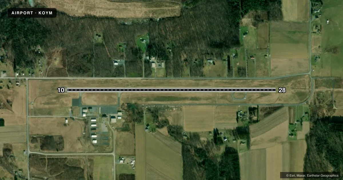
Runways & pattern
Full pagePattern entry · RWY 28
LEFT TRAFFICRunway end performance
| End | TORA | TODA | ASDA | LDA | VGSI | Approach lights | Obstruction |
|---|---|---|---|---|---|---|---|
| 10 | — | — | — | — | PAPI 4-box left(3°) | — | 142', trees, 3684' from thr, 340' R of cntrln, slope 24 |
| 28 | — | — | — | — | PAPI 4-box left(3°) | MALS | 72', trees, 2372' from thr, 523' R of cntrln, slope 30 |
Declared distances in feet. TORA = takeoff run available, TODA = takeoff distance, ASDA = accelerate-stop, LDA = landing distance.
Airport sketch
Runways drawn to scale from FAA survey coordinates, rendered over satellite imagery. Not for navigation.
Approaches & charts
ILS · 1
Services on the field
Fuel grades, oxygen, maintenance, ramp storage and lighting — as declared to the FAA by the airport operator.
Fuel & services
- Fuel
- 100LLA
- Oxygen (bottled)
- Not available
- Oxygen (bulk)
- Not available
- Airframe repair
- Major
- Power plant repair
- Major
- Other services
- INSTR
Ramp & ground
- Transient storage
- Tie-down
- Landing fee
- No fee published
- Customs
- Not available
- Lighting schedule
- SEE RMK
- Beacon schedule
- SS-SR
- Beacon
- White / Green (civil land)(WG)
- Wind indicator
- Yes
- Segmented circle
- Yes
Fuel & FBOs
Cheapest 100LL and Jet A on the field and nearby. Always confirm with the FBO before taxi.
Airport notes
Surface conditions, obstructions, local procedures, lighting outages and other notes published with each FAA cycle.
General notes
- FOR CD CTC CLEVELAND ARTCC AT 440-774-0234.
- COLD TEMPERATURE AIRPORT. ALTITUDE CORRECTION REQUIRED AT OR BELOW -36C.
Lighting notes
- ACTVT MALS RWY 28; PAPI RWYS 10 & 28; MIRL RWY 10/28 - CTAF.
Approach & departure obstructions
- 10+7 FT FENCE 200 FT N OF RY 0-200 FT. +15 FT PUBLIC ROAD 0-200 FT & 225 FT L. PUBLIC ROAD OBSTN MKD BY LIGHTED POLES.
- 28+13 FT FENCE N OF RY FM 0-176 FT, 219 FT LEFT. +23 FT PUBLIC ROAD, 222 FT RIGHT. PUBLIC ROAD OBSTN MKD BY LIGHTED POLES.
- 10PAPI UNUSBL BYD 5 DEGS RIGHT OF CNTRLN.
- 28PAPI UNUSBL BYD 8 DEGS RIGHT OF CNTRLN.
VFR map & nearby airports
VFR sectional. Tap any ICAO chip to open that airport.
Key facts · KOYM
Answer card- ICAO
- KOYM
- Name
- ST MARYS MUNI
- Location
- ST MARYS, PENNSYLVANIA
- Elevation
- 1,934.3 ft MSL
- Traffic pattern altitude
- 2,934.3 ft MSL (1,000 AGL)
- Control tower
- Non-towered (use CTAF)
- Total runways
- 1
- Longest runway
- 10/28 · 4,300 ft
- Published ILS approaches
- 1
- Published frequencies
- 2
- Magnetic variation
- 11°
- Current flight rules
- VFR
- Current wind
- 290° at 4 kt
- Favored runway now
- RWY 28
St Marys Muni (KOYM) sits in St Marys, Pennsylvania. The field elevation is 1,934.3 ft MSL. It has one runway, 10/28, which is 4,300 ft long with an asphalt surface. There is no control tower. CTAF and UNICOM are both 122.7.
The airport has one ILS approach on runway 28. Published remarks say the medium intensity approach lighting system for runway 28 is activated on the CTAF. The precision approach path indicators for runways 10 and 28 are also activated on the CTAF. The PAPI on both ends has a limited usable sector, so check your alignment early on final. The field is a cold temperature airport. Altitude correction is required at or below minus 36 degrees Celsius.
Pattern altitude is not published. Use the standard 1,000 ft AGL for light piston traffic unless the current FAA Chart Supplement says otherwise. That puts the pattern at about 2,934 ft MSL based on the listed field elevation. St. Marys Municipal Airport is on the field. It carries 100LL and Jet A with Prist. The airport also has runway edge lighting and approach lighting on runway 28. Watch the published fence and road obstructions near both runway ends. This is a high-elevation field, so performance planning matters on warm days.