METAR & TAF KBFD
Current METAR
Observed 12:53Z
KBFD 271253Z AUTO 26003KT 5SM BR OVC005 18/17 A2994 RMK AO2 SLP127 T01830172
- Wind
- 260° @ 3 kt
- Visibility
- 5 SM
- Temp / Dew
- 18°C / 17°C
- Altimeter
- 29.94 inHg
- Clouds
- OVC
- Density alt
- 2,993 ft
- Ceiling
- 500 ft AGL
- Rules
- IFR
Airport info & contacts
Manager on record, flight service, ARTCC, attendance schedule and pattern altitude — published by the FAA and refreshed every 28 days.
Location
- From city
- 10 NM S
- VFR sectional
- DETROIT
- ARTCC
- ZOB · CLEVELAND
- NOTAM facility
- BFD (NOTAM-D)
Airport manager
- Name
- ALICIA DANKESREITER
- Phone
- 814-368-5928
- Address
- 212 AIRPORT DR SUITE E, LEWIS RUN PA 16738
Flight service · Hours
- FSS AOO
- ALTOONA1-800-WX-BRIEF
- Attendance
- MON-FRI · 0700-2000
- SAT · 0700-2000
- SUN · 0700-2000
Frequencies
Tap any row to copy the frequency to your clipboard.
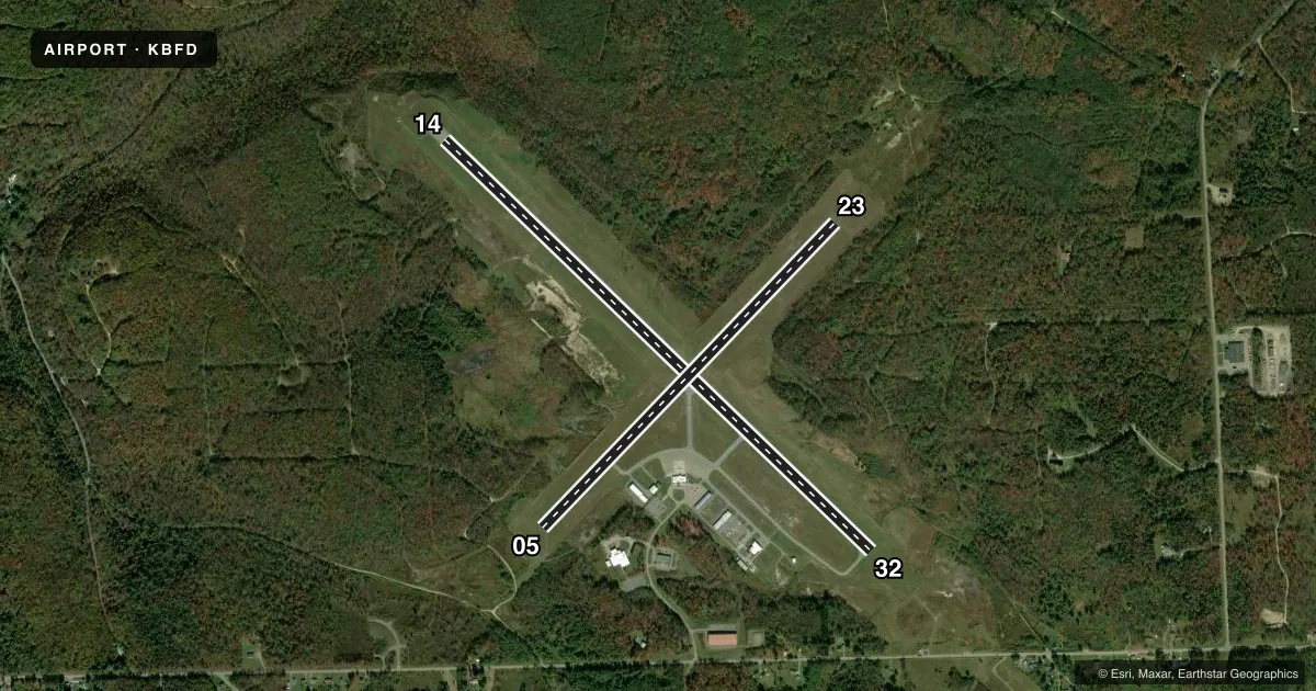
Runways & pattern
Full pagePattern entry · RWY 23
LEFT TRAFFIC| Runway | Heading (°M) | Length | Surface | Traffic |
|---|---|---|---|---|
| 14/32 | 123° / 303° | 6,307 ft | ASPH | Standard L |
| 05/23Favored | 33° / 213° | 4,499 ft | ASPH | Standard L |
Runway end performance
| End | TORA | TODA | ASDA | LDA | VGSI | Approach lights | Obstruction |
|---|---|---|---|---|---|---|---|
| 14 | 6,306' | 6,306' | 6,306' | 6,306' | VASI 4-box left(3°) | — | 34', tree, 1179' from thr, 483' R of cntrln, slope 28 |
| 32 | 6,306' | 6,306' | 6,306' | 6,306' | — | MALSR | 73', tree, 2872' from thr, 863' R of cntrln, slope 36 |
| 05 | 4,499' | 4,499' | 4,499' | 4,499' | — | — | 13', tree, 331' from thr, 82' R of cntrln, slope 10 |
| 23 | 4,499' | 4,499' | 4,499' | 4,499' | PAPI 4-box left(3°) | — | 25', tree, 671' from thr, 33' R of cntrln, slope 18 |
Declared distances in feet. TORA = takeoff run available, TODA = takeoff distance, ASDA = accelerate-stop, LDA = landing distance.
Airport sketch
Runways drawn to scale from FAA survey coordinates, rendered over satellite imagery. Not for navigation.
Approaches & charts
ILS · 1
Services on the field
Fuel grades, oxygen, maintenance, ramp storage and lighting — as declared to the FAA by the airport operator.
Fuel & services
- Fuel
- 100LLA+
- Oxygen (bottled)
- Not available
- Oxygen (bulk)
- Not available
- Airframe repair
- Minor
- Power plant repair
- Minor
- Other services
- CARGO,CHTR,INSTR,RNTL
Ramp & ground
- Transient storage
- Hangar
- Landing fee
- Yes
- Customs
- Not available
- Lighting schedule
- SEE RMK
- Beacon schedule
- SS-SR
- Beacon
- White / Green (civil land)(WG)
- Wind indicator
- Lighted
- Segmented circle
- No
Fuel & FBOs
Cheapest 100LL and Jet A on the field and nearby. Always confirm with the FBO before taxi.
Airport notes
Surface conditions, obstructions, local procedures, lighting outages and other notes published with each FAA cycle.
General notes
- DEER & BIRDS ON & INVOF ARPT.
- AIRCRAFT DEICING AVAIL
- ARPT UNATNDD, NO SNOW REMOVAL AVBL DAILY 2000-0700.
- FOR CD CTC CLEVELAND ARTCC AT 440-774-0227.
- CONDS NOT MNT OUTSIDE NML HRS OF ATNDC.
Lighting notes
- ACTVT MALSR RWY 32; REIL RWY 05, 23 & 14; VASI RWY 14; PAPI RWY 23; MIRL RWY 05/23; HIRL RWY 14/32; TWY LGTS - CTAF.
Runway surface & condition
- 05/23PCR VALUE: 181/F/D/Y/U
- 14/32PCR VALUE: 343/F/D/W/T
Approach & departure obstructions
- 32MALSR UNMONITORED.
Other notes
- OPS PRIOR TO 1959.
- PPR 24 HRS FOR UNSKED ACFT OPS WITH MORE THAN 30 PSGR SEATS; CALL AMGR 814-368-5928 X 10. INDEX "B" COVERAGE AVBL 0700-2000; AFTER 2000 FOR EMERG CALL MCKEAN COUNTY 911 AT 814-887-4911.
- MANAGEREXT 10
VFR map & nearby airports
VFR sectional. Tap any ICAO chip to open that airport.
Key facts · KBFD
Answer card- ICAO
- KBFD
- Name
- BRADFORD RGNL
- Location
- BRADFORD, PENNSYLVANIA
- Elevation
- 2,143.1 ft MSL
- Traffic pattern altitude
- 3,143.1 ft MSL (1,000 AGL)
- Control tower
- Non-towered (use CTAF)
- Total runways
- 2
- Longest runway
- 14/32 · 6,307 ft
- Published ILS approaches
- 1
- Published frequencies
- 2
- Magnetic variation
- 11°
- Current flight rules
- IFR
- Current wind
- 260° at 3 kt
- Favored runway now
- RWY 23
Bradford Regional Airport is in Bradford, Pennsylvania. The field elevation is 2,143.1 ft MSL. It has two asphalt runways. The longest is runway 14/32 at 6,307 ft. There is no control tower, so expect CTAF and UNICOM use on 123.075.
One ILS is published here for runway 32. Pattern altitude is not published in the facts, so use the standard 1,000 ft AGL for light piston operations unless the current FAA Chart Supplement says otherwise. The on-field FBO is Bradford Regional Airport. It carries AVGAS 100LL, Jet A and Jet A Prist. Call ahead at (814) 368-5928 if you need current service details.
The airport sits in a higher-elevation part of Pennsylvania, so performance planning matters. Published remarks also note deer and birds in the area. The field is unattended. No snow removal is available daily from 2000 to 0700. Runway 32 has an unmonitored medium intensity approach lighting system with runway alignment indicator lights. Taxiway lights are controlled by CTAF. Clearance delivery is handled through Cleveland ARTCC. If you are bringing in a larger unscheduled flight with more than 30 passenger seats, prior permission is required 24 hours ahead.