METAR & TAF 8G3
8G3 does not publish a METAR.
Showing the nearest reporting station: KOLE (CATTARAUGUS COUNTY-OLEAN) · 10.5 NM away. Conditions at 8G3 may differ.
METAR · KOLE
Observed 16:15Z
KOLE 271615Z AUTO 00000KT 10SM SCT030 22/15 A2992 RMK AO2
- Wind
- 000° @ 0 kt
- Visibility
- 10 SM
- Temp / Dew
- 22°C / 15°C
- Altimeter
- 29.92 inHg
- Clouds
- SCT
- Density alt
- 2,601 ft
- Ceiling
- Unlimited
- Rules
- VFR
Airport info & contacts
Manager on record, flight service, ARTCC, attendance schedule and pattern altitude — published by the FAA and refreshed every 28 days.
Location
- From city
- 2 NM SE
- VFR sectional
- DETROIT
- ARTCC
- ZOB · CLEVELAND
- NOTAM facility
- BUF (NOTAM-D)
Airport manager
- Name
- PETER & PAUL GIERMEK
- Phone
- (716) 307-3581
- Address
- 1920 E RIVER RD, OLEAN NY 14760
Flight service · Hours
- FSS BUF
- BUFFALO1-800-WX-BRIEF
- Attendance
- MON-FRI · 1700-2000
- SAT-SUN · 0800-1600
Frequencies
Tap any row to copy the frequency to your clipboard.
Runways & pattern
Full pagePattern entry · RWY 10
LEFT TRAFFICRunway end performance
| End | TORA | TODA | ASDA | LDA | VGSI | Approach lights | Obstruction |
|---|---|---|---|---|---|---|---|
| 10 | — | — | — | — | — | — | 58', brush, 8' from thr, 94' R of cntrln, slope 0 |
| 28 | — | — | — | — | — | — | 63', trees, 63' from thr, 68' R of cntrln, slope 1 |
Declared distances in feet. TORA = takeoff run available, TODA = takeoff distance, ASDA = accelerate-stop, LDA = landing distance.
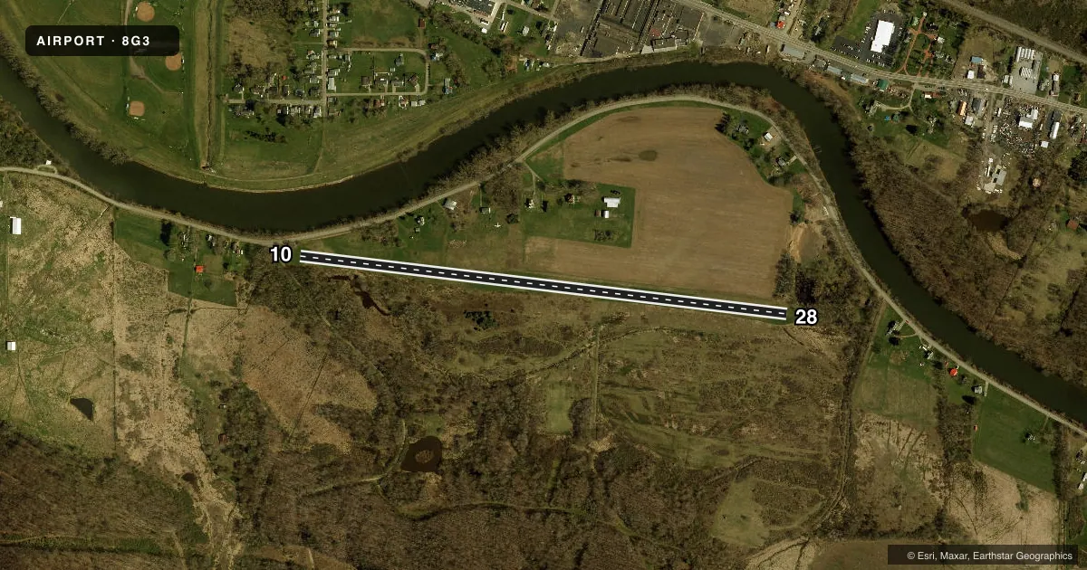
Airport sketch
Runways drawn to scale from FAA survey coordinates, rendered over satellite imagery. Not for navigation.
Approaches & charts
Services on the field
Fuel grades, oxygen, maintenance, ramp storage and lighting — as declared to the FAA by the airport operator.
Fuel & services
- Fuel
- Not available
- Oxygen (bottled)
- Not available
- Oxygen (bulk)
- Not available
Ramp & ground
- Transient storage
- Tie-down
- Hangar
- Landing fee
- No fee published
- Customs
- Not available
- Wind indicator
- Yes
- Segmented circle
- No
Fuel & FBOs
Cheapest 100LL and Jet A on the field and nearby. Always confirm with the FBO before taxi.
Airport notes
Surface conditions, obstructions, local procedures, lighting outages and other notes published with each FAA cycle.
General notes
- ARPT CLSD NGTS.
- DEER & MIGRATORY BIRDS ON AND INVOF ARPT.
- RY NOT SNOW PLOWED. CALL 716-307-8966 OR 716-307-3581 FOR CONDITIONS.
- FOR CD CTC CLEVELAND ARTCC AT 440-774-0227.
Runway surface & condition
- 10/28RY 10/28 WIDTH VARIES 80 FT-100 FT.
Approach & departure obstructions
- 10CTLNG OBSTN EXCEEDS 45 DEG SLP.
- 10RWY 10 & 28 RWY ENDS HAVE NMRS TREES 30-70 FT ON CNTRLN & BOTH SIDES.
Other notes
- PUBLIC USE IN ACCORDANCE WITH VFR.
- FREQUENT AIR AMBULANCE OPERATIONS INVOF ARPT ON CTAF FREQ.
- MANAGERDURING DAYLIGHT HOURS CALL MGR CELL PHONE AT 716-307-8966 OR 716-307-3581.
VFR map & nearby airports
VFR sectional. Tap any ICAO chip to open that airport.
Key facts · 8G3
Answer card- ICAO
- 8G3
- Name
- GIERMEK EXEC
- Location
- OLEAN, NEW YORK
- Elevation
- 1,420 ft MSL
- Traffic pattern altitude
- 2,420 ft MSL (1,000 AGL)
- Control tower
- Non-towered (use CTAF)
- Total runways
- 1
- Longest runway
- 10/28 · 3,150 ft
- Published ILS approaches
- 0
- Published frequencies
- 2
- Magnetic variation
- 10°
- Current flight rules
- VFR
- Current wind
- 000° at 0 kt
- Favored runway now
- –
Giermek Exec Airport sits in Olean, New York. The field elevation is 1,420 ft MSL. It has one runway. Runway 10/28 is 3,150 ft of turf, which makes the longest runway 3,150 ft. The airport is not towered. CTAF and UNICOM are both 122.8. No ILS approaches are published.
The pattern altitude is not published. Use 2,420 ft MSL as the standard 1,000 ft AGL reference for light piston traffic unless the current Chart Supplement says otherwise. The airport is closed at night. Public use is by VFR only. Frequent air ambulance traffic operates in the area on CTAF, so keep your scan active and expect radio work around the field. There are also deer and migratory birds in the vicinity. Runway 10 and 28 have numerous trees on the centerline and both sides, with controlling obstruction noted on the 10 end. The runway width also varies from 80 ft to 100 ft.
No on-field FBOs are listed. Call the airport manager during daylight hours at 716-307-8966 or 716-307-3581 for field conditions. The runway is not snow plowed, so verify surface condition before you go. If you need clearance delivery, contact Cleveland ARTCC at 440-774-0227.