METAR & TAF KELZ
Current METAR
Observed 12:56Z
KELZ 271256Z AUTO 29006KT 5SM BR OVC005 18/17 A2994 RMK AO2 SLP130 T01830172 $
- Wind
- 290° @ 6 kt
- Visibility
- 5 SM
- Temp / Dew
- 18°C / 17°C
- Altimeter
- 29.94 inHg
- Clouds
- OVC
- Density alt
- 2,970 ft
- Ceiling
- 500 ft AGL
- Rules
- IFR
Airport info & contacts
Manager on record, flight service, ARTCC, attendance schedule and pattern altitude — published by the FAA and refreshed every 28 days.
Location
- From city
- 2 NM SW
- VFR sectional
- DETROIT
- ARTCC
- ZOB · CLEVELAND
- NOTAM facility
- ELZ (NOTAM-D)
Airport manager
- Name
- WILLIS SHUTT
- Phone
- 585-593-3350
- Address
- 2600 TARANTINE RD., WELLSVILLE NY 14895
Flight service · Hours
- FSS BUF
- BUFFALO1-800-WX-BRIEF
- Attendance
- MON-FRI · 0800-1630
Frequencies
Tap any row to copy the frequency to your clipboard.
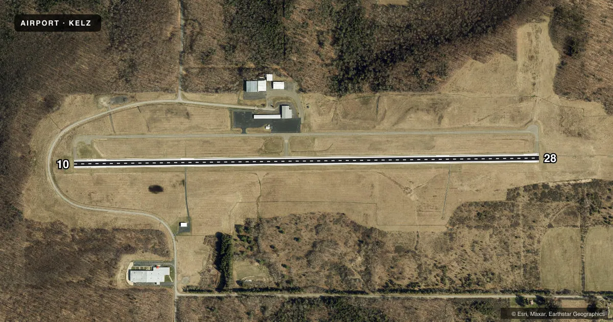
Runways & pattern
Full pagePattern entry · RWY 28
LEFT TRAFFICRunway end performance
| End | TORA | TODA | ASDA | LDA | VGSI | Approach lights | Obstruction |
|---|---|---|---|---|---|---|---|
| 10 | — | — | — | — | PAPI 2-box left(3°) | — | 43', trees, 631' from thr, 442' R of cntrln, slope 10 |
| 28 | — | — | — | — | PAPI 2-box left(3°) | MALS | 45', tree, 1241' from thr, 400' R of cntrln, slope 23 |
Declared distances in feet. TORA = takeoff run available, TODA = takeoff distance, ASDA = accelerate-stop, LDA = landing distance.
Airport sketch
Runways drawn to scale from FAA survey coordinates, rendered over satellite imagery. Not for navigation.
Approaches & charts
Services on the field
Fuel grades, oxygen, maintenance, ramp storage and lighting — as declared to the FAA by the airport operator.
Fuel & services
- Fuel
- 100LLA
- Oxygen (bottled)
- Not available
- Oxygen (bulk)
- Not available
- Airframe repair
- Major
- Power plant repair
- Major
- Other services
- AFRT,CARGO,CHTR,INSTR,RNTL,SALES
Ramp & ground
- Transient storage
- Tie-down
- Hangar
- Landing fee
- Yes
- Customs
- Not available
- Lighting schedule
- SEE RMK
- Beacon schedule
- SEE RMK
- Beacon
- White / Green (civil land)(WG)
- Wind indicator
- Lighted
- Segmented circle
- No
Fuel & FBOs
Cheapest 100LL and Jet A on the field and nearby. Always confirm with the FBO before taxi.
Airport notes
Surface conditions, obstructions, local procedures, lighting outages and other notes published with each FAA cycle.
General notes
- (E25) BASED ON AN ULTIMATE LENGTH OF 5700 FT.
- FOR CD CTC CLEVELAND ARTCC AT 440-774-0227.
- PILOTS CONDUCTING EFVS OPS; BE AWARE LED ALS IN USE RWY 28.
Lighting notes
- BCN ON DUSK-DAWN DLY.
- ACTVT MALS RWY 28; REIL RWY 10; PAPI RWY 10 & 28; HIRL RWY 10/28 - CTAF.
Approach & departure obstructions
- 1015 FT ROAD AND 9 FT FENCE 250 - 460 FT RIGHT.
- 10PAPI UNUSBL BYD 9 DEGS RIGHT AND LEFT OF CNTRLN.
- 10RWY 10 CLNC SLP 19:1 TO DTHR.
Other notes
- 7UNATNDD WKENDS, MEMORIAL DAY, 4TH OF JULY, LABOR DAY, THANKSGIVING, CHRISTMAS EVE, CHRISTMAS & NEW YEARS DAY.
- 7AFT HRS SVCS AVBL CALL 585-593-3350 FOR NUMBERS. 24 HR ACCESS TO THE LOBBY AND RESTROOMS. 24 HR SELF SERVE AVGAS AND JET-A.
- MANAGERFAX: 585-593-1543
VFR map & nearby airports
VFR sectional. Tap any ICAO chip to open that airport.
Key facts · KELZ
Answer card- ICAO
- KELZ
- Name
- WELLSVILLE MUNI/TARANTINE FLD
- Location
- WELLSVILLE, NEW YORK
- Elevation
- 2,124.5 ft MSL
- Traffic pattern altitude
- 3,124.5 ft MSL (1,000 AGL)
- Control tower
- Non-towered (use CTAF)
- Total runways
- 1
- Longest runway
- 10/28 · 5,300 ft
- Published ILS approaches
- 0
- Published frequencies
- 2
- Magnetic variation
- 8°
- Current flight rules
- IFR
- Current wind
- 290° at 6 kt
- Favored runway now
- RWY 28
Wellsville Muni/Tarantine Fld (KELZ) sits in Wellsville, New York at 2,124.5 ft MSL. It has one runway, 10/28, which is 5,300 ft long and asphalt. The airport is not towered. CTAF and UNICOM are both 123.0.
No ILS approaches are published here. The pattern altitude is not published, so use the standard 1,000 ft AGL for light piston traffic unless the current Chart Supplement says otherwise. The field is based on an ultimate runway length of 5,700 ft. That matters if you are planning for performance or a heavier load at this elevation.
Wellsville Municipal Airport is the on-field FBO. It carries 100LL and Jet A. Self-serve fuel is available 24 hours. The lobby and restrooms also have 24-hour access. The airport is unattended on weekends and on Memorial Day, Fourth of July, Labor Day, Thanksgiving, Christmas Eve, Christmas and New Year's Day.
Runway 28 has MALSR lighting. Runway 10 has REIL and PAPI lighting. Runway 10 also has a road and fence off the right side near the approach end. Runway 10 has a published clearance slope to the displaced threshold. Use CTAF for communications. If you need a clearance, contact Cleveland ARTCC. For a first look, the big items here are the elevation, the lighting setup and the lack of an ILS.