METAR & TAF N38
Current METAR
Observed 06:55Z
KN38 270655Z AUTO 23003KT 10SM FEW029 SCT034 16/16 A2989 RMK AO2
- Wind
- 230° @ 3 kt
- Visibility
- 10 SM
- Temp / Dew
- 16°C / 16°C
- Altimeter
- 29.89 inHg
- Clouds
- SCT
- Density alt
- 2,503 ft
- Ceiling
- Unlimited
- Rules
- VFR
Airport info & contacts
Manager on record, flight service, ARTCC, attendance schedule and pattern altitude — published by the FAA and refreshed every 28 days.
Location
- From city
- 4 NM SW
- VFR sectional
- DETROIT
- ARTCC
- ZNY · NEW YORK
- NOTAM facility
- IPT (NOTAM-D)
Airport manager
- Name
- SHAW SIGLIN
- Phone
- (570) 724-3746
- Address
- 112 RUNWAY ROAD, WELLSBORO PA 16901
Flight service · Hours
- FSS IPT
- WILLIAMSPORT1-800-WX-BRIEF
- Attendance
- MON-FRI · 1000-1500
- SAT-SUN · UNATT
Frequencies
Tap any row to copy the frequency to your clipboard.
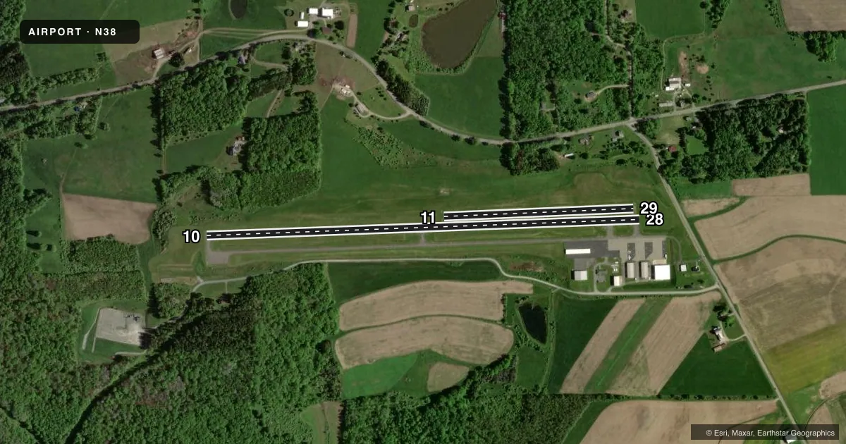
Runways & pattern
Full pagePattern entry · RWY 28
LEFT TRAFFIC| Runway | Heading (°M) | Length | Surface | Traffic |
|---|---|---|---|---|
| 10/28Favored | 77° / 257° | 3,597 ft | ASPH | Standard L |
| 11/29 | 77° / 257° | 1,576 ft | TURF | Standard L |
Runway end performance
| End | TORA | TODA | ASDA | LDA | VGSI | Approach lights | Obstruction |
|---|---|---|---|---|---|---|---|
| 10 | — | — | — | — | — | — | 45', trees, 582' from thr, 298' R of cntrln, slope 8 |
Declared distances in feet. TORA = takeoff run available, TODA = takeoff distance, ASDA = accelerate-stop, LDA = landing distance.
Airport sketch
Runways drawn to scale from FAA survey coordinates, rendered over satellite imagery. Not for navigation.
Approaches & charts
Services on the field
Fuel grades, oxygen, maintenance, ramp storage and lighting — as declared to the FAA by the airport operator.
Fuel & services
- Fuel
- 100LLA
- Oxygen (bottled)
- Not available
- Oxygen (bulk)
- Not available
- Airframe repair
- Not available
- Power plant repair
- Not available
Ramp & ground
- Transient storage
- Tie-down
- Hangar
- Landing fee
- No fee published
- Customs
- Not available
- Lighting schedule
- SEE RMK
- Beacon schedule
- SS-SR
- Beacon
- White / Green (civil land)(WG)
- Wind indicator
- Lighted
- Segmented circle
- No
Fuel & FBOs
Cheapest 100LL and Jet A on the field and nearby. Always confirm with the FBO before taxi.
Airport notes
Surface conditions, obstructions, local procedures, lighting outages and other notes published with each FAA cycle.
General notes
- TURF RWY 11/29 1600 FT X 100 FT DAY VFR ONLY; NON SIMULTANEOUS OPS; CLSD ANNUALLY DEC-APR.
- FOR CD CTC NEW YORK ARTCC AT 631-468-1425.
Lighting notes
- ACTVT REIL RWY 28; MIRL 10/28 - CTAF.
Other notes
- MANAGER(570) 439-8103
VFR map & nearby airports
VFR sectional. Tap any ICAO chip to open that airport.
Key facts · N38
Answer card- ICAO
- N38
- Name
- GRAND CANYON RGNL
- Location
- WELLSBORO, PENNSYLVANIA
- Elevation
- 1,891.5 ft MSL
- Traffic pattern altitude
- 2,891.5 ft MSL (1,000 AGL)
- Control tower
- Non-towered (use CTAF)
- Total runways
- 2
- Longest runway
- 10/28 · 3,597 ft
- Published ILS approaches
- 0
- Published frequencies
- 4
- Magnetic variation
- 11°
- Current flight rules
- VFR
- Current wind
- 230° at 3 kt
- Favored runway now
- RWY 28
Grand Canyon Rgnl (N38) sits in Wellsboro, Pennsylvania. The field elevation is 1,891.5 ft MSL. It has two runways. The longest is 10/28 at 3,597 ft. There is no control tower. The published approach setup does not include any ILS approaches.
For pattern work, the charted pattern altitude is not published. Use the standard 1,000 ft AGL pattern for light piston operations unless the current Chart Supplement says otherwise. The airport sits in a higher-elevation part of north central Pennsylvania. That means density altitude deserves attention on warm days. Runway 10/28 is asphalt. Runway 11/29 is turf and is listed for day VFR only. It is also closed each year from December through April. Non-simultaneous operations are permitted on the turf strip.
Published remarks note medium intensity runway lights on 10 and 28. Runway end identifier lights are available on 28. Lighting is controlled by CTAF. There are no on-field FBOs listed in the facts. Check current fuel and service availability with the airport operator or the field directly before arrival. For clearance delivery, contact New York ARTCC. If you are planning a night or IFR arrival, verify the current Chart Supplement before departure.