METAR & TAF KLHV
KLHV does not publish a METAR.
Showing the nearest reporting station: KIPT (WILLIAMSPORT RGNL) · 23.5 NM away. Conditions at KLHV may differ.
METAR · KIPT
Observed 04:54Z
KIPT 270454Z AUTO 33004KT 10SM CLR 20/17 A2984 RMK AO2 SLP102 T02000167 402890167 $
- Wind
- 330° @ 4 kt
- Visibility
- 10 SM
- Temp / Dew
- 20°C / 17°C
- Altimeter
- 29.84 inHg
- Clouds
- CLR
- Density alt
- 1,388 ft
- Ceiling
- Unlimited
- Rules
- VFR
Airport info & contacts
Manager on record, flight service, ARTCC, attendance schedule and pattern altitude — published by the FAA and refreshed every 28 days.
Location
- From city
- 2 NM E
- VFR sectional
- DETROIT
- ARTCC
- ZNY · NEW YORK
- NOTAM facility
- IPT (NOTAM-D)
Airport manager
- Name
- DOUGLAS WENKER
- Phone
- 570-748-5123
- Address
- 353 PROCTOR STREET, LOCK HAVEN PA 17745
Flight service · Hours
- FSS IPT
- WILLIAMSPORT1-800-WX-BRIEF
- Attendance
- NOV-APR · MON - FRI · 0800-1600
- SAT-SUN · 1000-1400
- APR-NOV · MON-FRI · 0800-1700
Frequencies
Tap any row to copy the frequency to your clipboard.
Runways & pattern
Full pagePattern entry · RWY 27R
RIGHT TRAFFIC| Runway | Heading (°M) | Length | Surface | Traffic |
|---|---|---|---|---|
| 09L/27RFavored | 71° / 251° | 3,799 ft | ASPH | 27R R |
| 09R/27L | 71° / 251° | 2,179 ft | TURF | 27L R |
Runway end performance
| End | TORA | TODA | ASDA | LDA | VGSI | Approach lights | Obstruction |
|---|---|---|---|---|---|---|---|
| 09L | — | — | — | — | PAPI 2-box left(3.5°) | — | 44', trees, 895' from thr, 159' R of cntrln, slope 15 |
| 27R | — | — | — | — | PAPI 2-box left(4°) | — | 44', trees, 323' from thr, 109' R of cntrln, slope 2 |
| 27L | — | — | — | — | — | — | 69', trees, 1257' from thr, 84' R of cntrln, slope 18 |
Declared distances in feet. TORA = takeoff run available, TODA = takeoff distance, ASDA = accelerate-stop, LDA = landing distance.
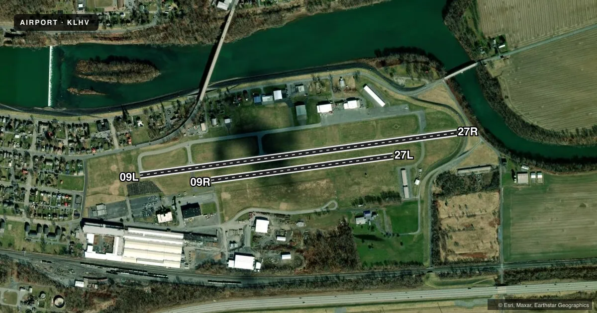
Airport sketch
Runways drawn to scale from FAA survey coordinates, rendered over satellite imagery. Not for navigation.
Approaches & charts
Services on the field
Fuel grades, oxygen, maintenance, ramp storage and lighting — as declared to the FAA by the airport operator.
Fuel & services
- Fuel
- 100LLA
- Oxygen (bottled)
- Not available
- Oxygen (bulk)
- Not available
- Airframe repair
- Major
- Power plant repair
- Major
Ramp & ground
- Transient storage
- Tie-down
- Hangar
- Landing fee
- No fee published
- Customs
- Not available
- Lighting schedule
- SEE RMK
- Beacon schedule
- SS-SR
- Beacon
- White / Green (civil land)(WG)
- Wind indicator
- Lighted
- Segmented circle
- Yes
Fuel & FBOs
Cheapest 100LL and Jet A on the field and nearby. Always confirm with the FBO before taxi.
Airport notes
Surface conditions, obstructions, local procedures, lighting outages and other notes published with each FAA cycle.
General notes
- LOCAL WX ON CTAF (3 CLICKS).
- BIRD ACTIVITY ON & INVOF ARPT.
- NO SIMULTANEOUS RWY OPS.
- FOR CD CTC NEW YORK ARTCC AT 631-468-1425.
- RWY 09R/27L CLSD SS-SR DLY.
Lighting notes
- ACTVT PAPI RWY 09L & 27R; MIRL RWY 09L/27R - CTAF.
Fuel notes
- 100LLFUEL AVBL AFT HOURS BY PRIOR REQ; CALL 570-295-7952 OR 570-726-3462.
Approach & departure obstructions
- 27R14 FT BERM 84 FT OUT ON CNTRLN RWY 27R.
- 09RWHITE CONES MARK RWY EDGE AND THLD.
- 27LWHITE CONES MARK RWY EDGE AND THLD.
- 09LUNUSBL BYD 5 DEGS LEFT OF CNTRLN.
- 27RUNUSBL BYD 6 DEGS LEFT & 8 DEGS RIGHT OF CNTRLN.
Other notes
- ARPT IN EXISTENCE PRIOR TO RULING MAY 1959.
VFR map & nearby airports
VFR sectional. Tap any ICAO chip to open that airport.
Key facts · KLHV
Answer card- ICAO
- KLHV
- Name
- WILLIAM T PIPER MEML
- Location
- LOCK HAVEN, PENNSYLVANIA
- Elevation
- 555.5 ft MSL
- Traffic pattern altitude
- 1,555.5 ft MSL (1,000 AGL)
- Control tower
- Non-towered (use CTAF)
- Total runways
- 2
- Longest runway
- 09L/27R · 3,799 ft
- Published ILS approaches
- 0
- Published frequencies
- 2
- Magnetic variation
- 11°
- Current flight rules
- VFR
- Current wind
- 330° at 4 kt
- Favored runway now
- RWY 27R
William T Piper Meml Airport is in Lock Haven, Pennsylvania. Field elevation is 555.5 ft MSL. The airport has two runways. The longest is 3,799 ft. There is no control tower, so plan for self-announce traffic on CTAF 122.8. No ILS approaches are published here. Pattern altitude is not published. Use the standard 1,000 ft AGL pattern unless the current Chart Supplement says otherwise.
Runway 09L/27R is asphalt and runway 09R/27L is turf. The turf runway is closed from sunset to sunrise daily. Published remarks also say no simultaneous runway operations are permitted. That matters here. Runway 27R has a 14-foot berm 84 feet out on the centerline. Runway 27R is also unusable beyond 6 degrees left and 8 degrees right of centerline. Runway 09L is unusable beyond 5 degrees left of centerline. White cones mark the edge and threshold of runway 27L.
The on-field FBO is William T. Piper Memorial Airport. It carries 100LL and Jet A. Fuel is available after hours by prior request. Call the field directly for that. Bird activity is present on and near the airport. Local weather is available on CTAF by keying the mic three times. For clearance delivery, contact New York ARTCC. This is a non-towered field, so brief your taxi, runway choice and lighting plan before you roll.