METAR & TAF N74
N74 does not publish a METAR.
Showing the nearest reporting station: KUNV (STATE COLLEGE RGNL) · 11.4 NM away. Conditions at N74 may differ.
METAR · KUNV
Observed 12:53Z
KUNV 271253Z 22003KT 10SM SCT048 22/19 A2991
- Wind
- 220° @ 3 kt
- Visibility
- 10 SM
- Temp / Dew
- 22°C / 19°C
- Altimeter
- 29.91 inHg
- Clouds
- SCT
- Density alt
- 2,396 ft
- Ceiling
- Unlimited
- Rules
- VFR
Airport info & contacts
Manager on record, flight service, ARTCC, attendance schedule and pattern altitude — published by the FAA and refreshed every 28 days.
Location
- From city
- 4 NM NE
- VFR sectional
- DETROIT
- ARTCC
- ZNY · NEW YORK
- NOTAM facility
- AOO (NOTAM-D)
Airport manager
- Name
- RUSSELL E. SCHLEIDEN
- Phone
- 814-364-1479
- Address
- 3606 LOWER BRUSH VALLEY ROAD, CENTRE HALL PA 16828
Flight service · Hours
- FSS AOO
- ALTOONA1-800-WX-BRIEF
- Attendance
- IRREG
Frequencies
Tap any row to copy the frequency to your clipboard.
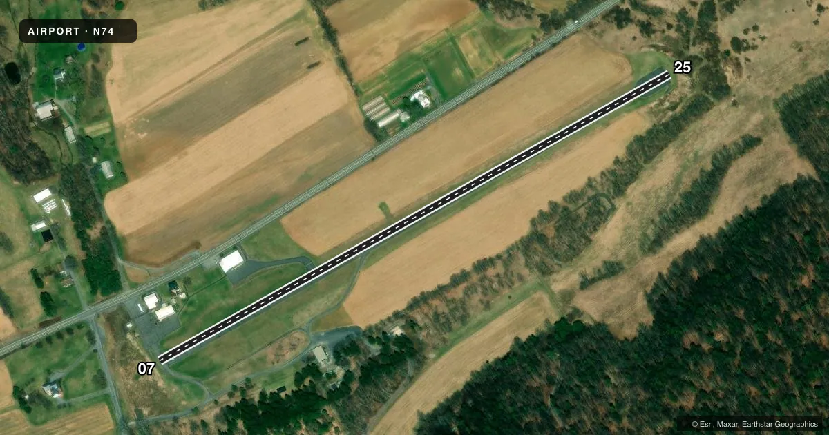
Runways & pattern
Full pagePattern entry · RWY 25
LEFT TRAFFICRunway end performance
| End | TORA | TODA | ASDA | LDA | VGSI | Approach lights | Obstruction |
|---|---|---|---|---|---|---|---|
| 07 | — | — | — | — | — | — | 52', tree, 616' from thr, 144' R of cntrln, slope 8 |
| 25 | — | — | — | — | — | — | 46', tree, 928' from thr, 189' R of cntrln, slope 15 |
Declared distances in feet. TORA = takeoff run available, TODA = takeoff distance, ASDA = accelerate-stop, LDA = landing distance.
Airport sketch
Runways drawn to scale from FAA survey coordinates, rendered over satellite imagery. Not for navigation.
Approaches & charts
Services on the field
Fuel grades, oxygen, maintenance, ramp storage and lighting — as declared to the FAA by the airport operator.
Fuel & services
- Fuel
- Not available
- Oxygen (bulk)
- Not available
- Airframe repair
- Not available
- Power plant repair
- Not available
Ramp & ground
- Transient storage
- Tie-down
- Landing fee
- No fee published
- Customs
- Not available
- Wind indicator
- Yes
- Segmented circle
- No
Fuel & FBOs
Cheapest 100LL and Jet A on the field and nearby. Always confirm with the FBO before taxi.
Airport notes
Surface conditions, obstructions, local procedures, lighting outages and other notes published with each FAA cycle.
General notes
- DEER ON & INVOF ARPT AT NIGHT.
- 750 FT AGL MTNS 1/2 MI S & 700 FT AGL MTN 1/2 MI N; BOTH UNLGTD & UNMKD.
- NO NIGHT OPERATIONS.
- FOR CD CTC NEW YORK ARTCC AT 631-468-1425.
Runway surface & condition
- 07/25FIRST 864 FT OF RY 07 HAS A 3.34 PER CENT UPSLOPE.
Other notes
- USE IN VFR CONDITIONS ONLY.
- 1FOR SVC CALL (814) 364-1479
VFR map & nearby airports
VFR sectional. Tap any ICAO chip to open that airport.
Key facts · N74
Answer card- ICAO
- N74
- Name
- PENNS CAVE
- Location
- CENTRE HALL, PENNSYLVANIA
- Elevation
- 1,245 ft MSL
- Traffic pattern altitude
- 2,245 ft MSL (1,000 AGL)
- Control tower
- Non-towered (use CTAF)
- Total runways
- 1
- Longest runway
- 07/25 · 2,509 ft
- Published ILS approaches
- 0
- Published frequencies
- 2
- Magnetic variation
- 10°
- Current flight rules
- VFR
- Current wind
- 220° at 3 kt
- Favored runway now
- RWY 25
Penns Cave Airport (N74) sits in Centre Hall, Pennsylvania. The field elevation is 1,245 ft MSL. It has one runway, 07/25, which is 2,509 ft long and asphalt. The airport is non-towered. CTAF and UNICOM are both 122.8. No ILS approaches are published.
Pattern altitude is not published, so use the standard 1,000 ft AGL for light piston aircraft unless the current Chart Supplement says otherwise. That puts the pattern at 2,245 ft MSL based on the field elevation. This airport is for VFR conditions only. No night operations are permitted. Deer are reported on and near the airport at night, so daylight arrivals and departures make more sense here.
Runway 07 has a 3.34 percent upslope for the first 864 ft. That can matter on takeoff roll and landing distance planning. There are also mountains about half a mile north and south of the field. They rise to 700 ft AGL and 750 ft AGL. Both are unlighted and unmarked. No on-field FBOs are listed. For service, call the airport at (814) 364-1479. For clearance delivery, contact New York ARTCC at 631-468-1425.