METAR & TAF P34
P34 does not publish a METAR.
Showing the nearest reporting station: KRVL (MIFFLIN COUNTY) · 11.1 NM away. Conditions at P34 may differ.
METAR · KRVL
Observed 09:35Z
KRVL 270935Z AUTO 00000KT 7SM CLR 17/16 A2987 RMK AO2
- Wind
- 000° @ 0 kt
- Visibility
- 7 SM
- Temp / Dew
- 17°C / 16°C
- Altimeter
- 29.87 inHg
- Clouds
- CLR
- Density alt
- 978 ft
- Ceiling
- Unlimited
- Rules
- VFR
Airport info & contacts
Manager on record, flight service, ARTCC, attendance schedule and pattern altitude — published by the FAA and refreshed every 28 days.
Location
- From city
- 2 NM N
- VFR sectional
- DETROIT
- ARTCC
- ZNY · NEW YORK
- NOTAM facility
- IPT (NOTAM-D)
Airport manager
- Name
- BRUCE LISLE
- Phone
- 717-436-2725
- Address
- 600 AIRPORT DR., MIFFLINTOWN PA 17059
Flight service · Hours
- FSS IPT
- WILLIAMSPORT1-800-WX-BRIEF
- Attendance
- Unattended
Frequencies
Tap any row to copy the frequency to your clipboard.
Runways & pattern
Full pagePattern entry · RWY 08
LEFT TRAFFICRunway end performance
| End | TORA | TODA | ASDA | LDA | VGSI | Approach lights | Obstruction |
|---|---|---|---|---|---|---|---|
| 08 | — | — | — | — | — | — | 42', trees, 214' from thr, 243' R of cntrln, slope 0 |
| 26 | — | — | — | — | — | — | 29', trees, 672' from thr, 143' R of cntrln, slope 16 |
Declared distances in feet. TORA = takeoff run available, TODA = takeoff distance, ASDA = accelerate-stop, LDA = landing distance.
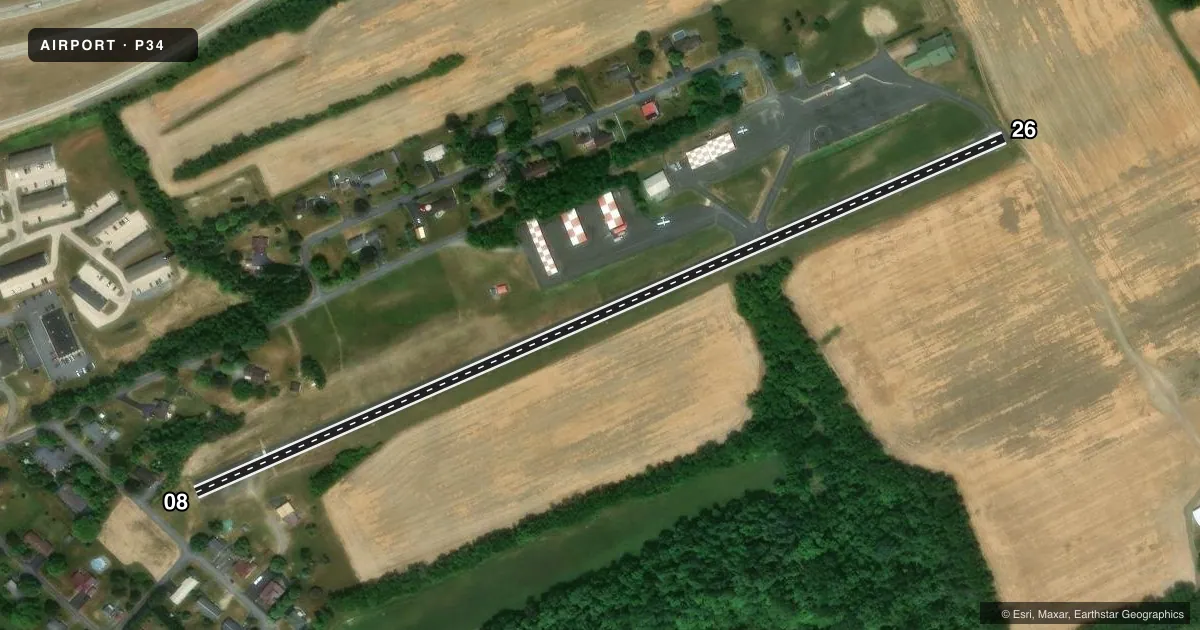
Airport sketch
Runways drawn to scale from FAA survey coordinates, rendered over satellite imagery. Not for navigation.
Approaches & charts
Services on the field
Fuel grades, oxygen, maintenance, ramp storage and lighting — as declared to the FAA by the airport operator.
Fuel & services
- Fuel
- Not available
- Airframe repair
- Not available
- Power plant repair
- Not available
Ramp & ground
- Transient storage
- Hangar
- Landing fee
- No fee published
- Lighting schedule
- SEE RMK
- Beacon schedule
- SEE RMK
- Beacon
- White / Green (civil land)(WG)
- Wind indicator
- Lighted
- Segmented circle
- No
Fuel & FBOs
Cheapest 100LL and Jet A on the field and nearby. Always confirm with the FBO before taxi.
Airport notes
Surface conditions, obstructions, local procedures, lighting outages and other notes published with each FAA cycle.
General notes
- FOR CD CTC NEW YORK ARTCC AT 631-468-1425.
Lighting notes
- ACTVT ROTG BCN - CTAF.
- ACTVT LIRL 08/26, WDI LGTS - CTAF.
Approach & departure obstructions
- 08RWY 08 HAS 20-50 FT HIGH TREES 150 FT FM RWY END TO 430 FT BHND RWY END, 60-170 FT L OF CNTRLN; 20-40 FT HIGH STRUCTURES & TREES 50 FT FM RWY END TO 530 FT BHND RWY END, 90-160 FT R OF CNTRLN.
- 08RWY 8 CLSD TO NGT VISUAL APCH DUE TO SEV APCH AND PRIM SFC OBSTNS.
- 26RWY NOT MKD FOR NPI APCH.
- 08APCH SLP 11:1 TO DTHR.
VFR map & nearby airports
VFR sectional. Tap any ICAO chip to open that airport.
Key facts · P34
Answer card- ICAO
- P34
- Name
- MIFFLINTOWN
- Location
- MIFFLINTOWN, PENNSYLVANIA
- Elevation
- 545 ft MSL
- Traffic pattern altitude
- 1,545 ft MSL (1,000 AGL)
- Control tower
- Non-towered (use CTAF)
- Total runways
- 1
- Longest runway
- 08/26 · 2,627 ft
- Published ILS approaches
- 0
- Published frequencies
- 2
- Magnetic variation
- 11°
- Current flight rules
- VFR
- Current wind
- 000° at 0 kt
- Favored runway now
- –
Mifflintown Airport (P34) sits in Mifflintown, Pennsylvania. Field elevation is 545 ft MSL. The airport has one runway. Runway 08/26 is 2,627 ft long and paved with asphalt. There is no control tower. CTAF and UNICOM are both 122.8.
No ILS approaches are published here. Pattern altitude is not published, so use 1,000 ft AGL for light piston traffic unless the current Chart Supplement says otherwise. The published remarks matter here. Runway 08 has severe approach and primary surface obstructions, so night visual approaches to Runway 08 are closed. Runway 26 is not marked for non-precision instrument approach. Low intensity runway lights are available on 08/26. The rotating beacon is active on CTAF.
There are no on-field FBOs listed in the facts. Contact the airport operator directly before arrival, or call the field on CTAF or UNICOM for current service status. For clearance delivery, contact New York ARTCC at 631-468-1425. This is a small non-towered field with one short runway, so plan your arrival carefully. Check the current Chart Supplement for any published noise or curfew restrictions before flying into the field.