METAR & TAF N96
N96 does not publish a METAR.
Showing the nearest reporting station: KUNV (STATE COLLEGE RGNL) · 2.6 NM away. Conditions at N96 may differ.
METAR · KUNV
Observed 00:53Z
KUNV 270053Z 27003KT 10SM SCT090 24/17 A2989
- Wind
- 270° @ 3 kt
- Visibility
- 10 SM
- Temp / Dew
- 24°C / 17°C
- Altimeter
- 29.89 inHg
- Clouds
- SCT
- Density alt
- 2,446 ft
- Ceiling
- Unlimited
- Rules
- VFR
Airport info & contacts
Manager on record, flight service, ARTCC, attendance schedule and pattern altitude — published by the FAA and refreshed every 28 days.
Location
- From city
- 3 NM SW
- VFR sectional
- DETROIT
- Pattern altitude
- 1,029 ft AGL · 2,101 ft MSL
- ARTCC
- ZNY · NEW YORK
- NOTAM facility
- AOO (NOTAM-D)
Airport manager
- Name
- JOHN ELNITSKI
- Phone
- 814-355-7407
- Address
- 225 SNOWBIRD LA, BELLEFONTE PA 16823
Flight service · Hours
- FSS AOO
- ALTOONA1-800-WX-BRIEF
- Attendance
- 0800-DUSK
Frequencies
Tap any row to copy the frequency to your clipboard.
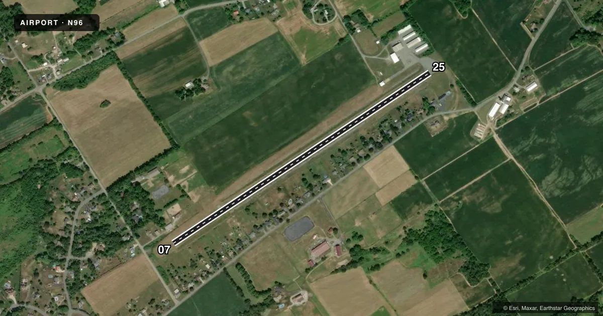
Runways & pattern
Full pagePattern entry · RWY 25
RIGHT TRAFFICRunway end performance
| End | TORA | TODA | ASDA | LDA | VGSI | Approach lights | Obstruction |
|---|---|---|---|---|---|---|---|
| 07 | — | — | — | — | — | — | 34', tree, 278' from thr, 233' R of cntrln, slope 2 |
| 25 | — | — | — | — | PAPI 2-box left(3.5°) | — | — |
Declared distances in feet. TORA = takeoff run available, TODA = takeoff distance, ASDA = accelerate-stop, LDA = landing distance.
Airport sketch
Runways drawn to scale from FAA survey coordinates, rendered over satellite imagery. Not for navigation.
Approaches & charts
Services on the field
Fuel grades, oxygen, maintenance, ramp storage and lighting — as declared to the FAA by the airport operator.
Fuel & services
- Fuel
- 100LLA
- Oxygen (bottled)
- Not available
- Oxygen (bulk)
- Not available
- Airframe repair
- Major
- Power plant repair
- Major
- Other services
- INSTR,RNTL,SALES
Ramp & ground
- Transient storage
- Tie-down
- Hangar
- Lighting schedule
- SEE RMK
- Beacon schedule
- SEE RMK
- Beacon
- White / Green (civil land)(WG)
- Wind indicator
- Yes
- Segmented circle
- No
Fuel & FBOs
Cheapest 100LL and Jet A on the field and nearby. Always confirm with the FBO before taxi.
Airport notes
Surface conditions, obstructions, local procedures, lighting outages and other notes published with each FAA cycle.
General notes
- ULTRA-LIGHTS ON & INVOF ARPT.
- ALL HELI RQRD TO USE FIXED WING TFC PAT.
- HVY GLIDER ACT DURG DALGT HRS, ALL ALTS WI 10 NM AREA, ALL DRCTNS, SPCLY ALG RIDGE 1 NM WEST & NORTH OF ARPT.
- CTC UNV TWR(UNIVERSITY PARK) 128.475 PRIOR TO ENTERING CLASS D ASP.
Lighting notes
- ACTVT ARPT BCN - 122.7.
- ACTVT PAPI RWY 25; LIRL RWY 07/25 - 122.7.
Runway surface & condition
- 07/25RWY 25 THR LGTS LCTD 43 FT PAST RWY THR MKG.
Approach & departure obstructions
- 07RWY MARKINGS EXTREMELY FADED.
- 25RWY MARKINGS EXTREMELY FADED.
Other notes
- 1FOR SVC AFT HRS CTC 814-355-7407 OR 814-883-7646.
VFR map & nearby airports
VFR sectional. Tap any ICAO chip to open that airport.
Key facts · N96
Answer card- ICAO
- N96
- Name
- BELLEFONTE
- Location
- BELLEFONTE, PENNSYLVANIA
- Elevation
- 1,071.5 ft MSL
- Traffic pattern altitude
- 2,100.5 ft MSL (1,029 AGL)
- Control tower
- Non-towered (use CTAF)
- Total runways
- 1
- Longest runway
- 07/25 · 3,632 ft
- Published ILS approaches
- 0
- Published frequencies
- 3
- Magnetic variation
- 10°
- Current flight rules
- VFR
- Current wind
- 270° at 3 kt
- Favored runway now
- RWY 25
Bellefonte Airport sits in Bellefonte, Pennsylvania. The field elevation is 1,071.5 ft MSL. It has one runway. Runway 07/25 is 3,632 ft long and asphalt. There is no control tower. No ILS approaches are published.
Pattern altitude is 1,029 ft AGL, which works out to 2,100.5 ft MSL. That matters here because the traffic mix is not simple. Published remarks call out heavy glider activity in daylight within 10 NM of the airport, especially along the ridge 1 NM west and north of the field. Ultralights are also on and in the vicinity of the airport. Helicopters are required to use the fixed-wing traffic pattern.
Pleasant Valley Aviation is on the field. It carries 100LL and Jet A. For after-hours service, use the phone numbers in the Chart Supplement or call the FBO directly. Runway 25 has PAPI. Low-intensity runway lights for 07/25 are activated on 122.7. The airport beacon is also activated on 122.7. Runway 25 threshold lights sit 43 ft past the threshold marking. Runway markings on both ends are extremely faded, so plan for a careful visual setup. The airport is near University Park Class D airspace. Contact University Park tower on 128.475 before entering that airspace.