METAR & TAF 1N3
1N3 does not publish a METAR.
Showing the nearest reporting station: KFIG (CLEARFIELD-LAWRENCE) · 9.1 NM away. Conditions at 1N3 may differ.
METAR · KFIG
Observed 12:54Z
KFIG 271254Z AUTO 20005KT 10SM SCT033 18/17 A2994 RMK AO2 SLP129 T01830172
- Wind
- 200° @ 5 kt
- Visibility
- 10 SM
- Temp / Dew
- 18°C / 17°C
- Altimeter
- 29.94 inHg
- Clouds
- SCT
- Density alt
- 2,547 ft
- Ceiling
- Unlimited
- Rules
- VFR
Airport info & contacts
Manager on record, flight service, ARTCC, attendance schedule and pattern altitude — published by the FAA and refreshed every 28 days.
Location
- From city
- 5 NM N
- VFR sectional
- DETROIT
- ARTCC
- ZNY · NEW YORK
- NOTAM facility
- AOO (NOTAM-D)
Airport manager
- Name
- JAMIE CONDON
- Phone
- (814) 553-4693
- Address
- 2174 DEER CREEK RD, MORRISDALE PA 16858
Flight service · Hours
- FSS AOO
- ALTOONA1-800-WX-BRIEF
- Attendance
- Unattended
Frequencies
Tap any row to copy the frequency to your clipboard.
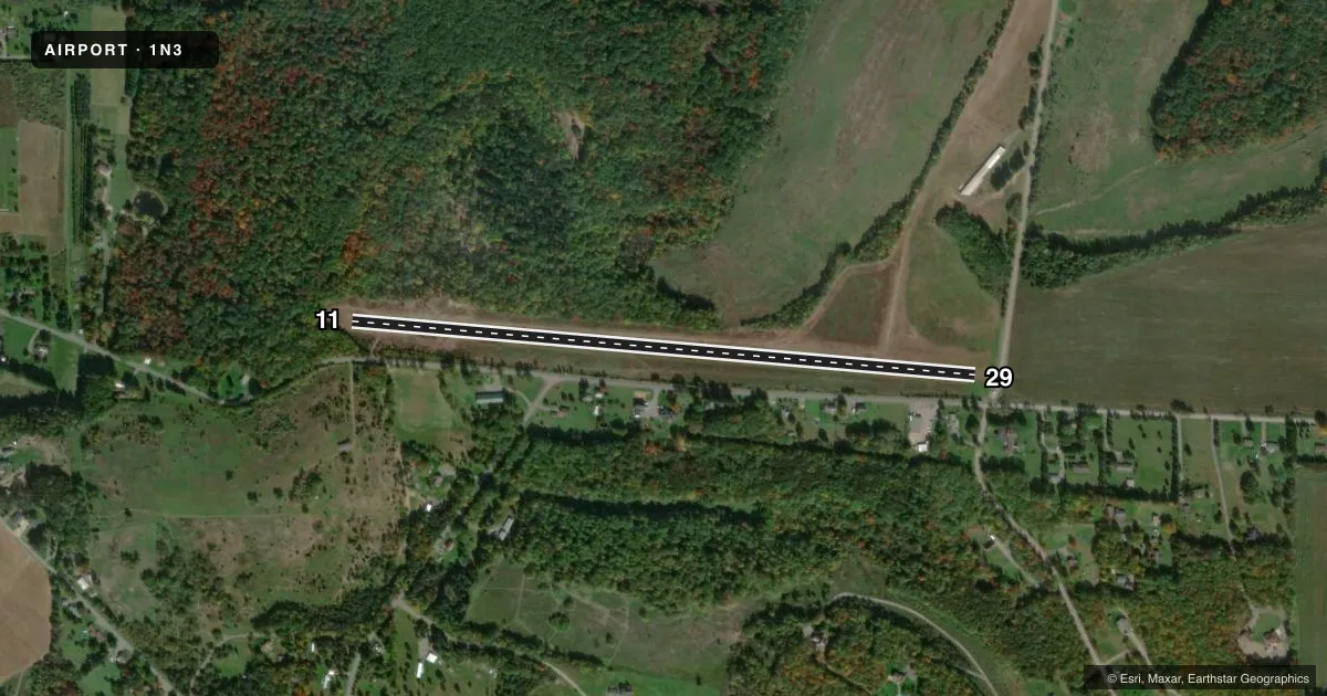
Runways & pattern
Full pagePattern entry · RWY 29
LEFT TRAFFICRunway end performance
| End | TORA | TODA | ASDA | LDA | VGSI | Approach lights | Obstruction |
|---|---|---|---|---|---|---|---|
| 11 | — | — | — | — | — | — | 50', trees, 39' from thr, 110' R of cntrln, slope 0 |
| 29 | — | — | — | — | — | — | 37', road, 210' from thr, 143' R of cntrln, slope 5 |
Declared distances in feet. TORA = takeoff run available, TODA = takeoff distance, ASDA = accelerate-stop, LDA = landing distance.
Airport sketch
Runways drawn to scale from FAA survey coordinates, rendered over satellite imagery. Not for navigation.
Approaches & charts
Services on the field
Fuel grades, oxygen, maintenance, ramp storage and lighting — as declared to the FAA by the airport operator.
Fuel & services
- Fuel
- Not available
- Oxygen (bottled)
- Not available
- Oxygen (bulk)
- Not available
- Airframe repair
- Not available
- Power plant repair
- Not available
Ramp & ground
- Transient storage
- Not published
- Landing fee
- No fee published
- Customs
- Not available
- Wind indicator
- Yes
- Segmented circle
- No
Fuel & FBOs
Cheapest 100LL and Jet A on the field and nearby. Always confirm with the FBO before taxi.
Airport notes
Surface conditions, obstructions, local procedures, lighting outages and other notes published with each FAA cycle.
General notes
- ULTRALIGHT OPNS ON & INVOF ARPT.
- BIRDS; DEER & GROUND HOGS ON & INVOF ARPT.
- FOR CD CTC NEW YORK ARTCC AT 631-468-1425.
Approach & departure obstructions
- 11RWY DTHR MKD WITH YELLOW CONES.
- 29RWY DTHR MKD WITH YELLOW CONES.
- 11RY EDGES MKD WITH YELLOW CONES.
- 29RY EDGES MKD WITH YELLOW CONES.
- 11CTLNG OBSTN EXCEEDS 45 DEG SLP TO THLD. APCH SLOPE 20:1 TO DTHR.
- 29APCH SLOPE 12:1 TO DTHR.
Other notes
- VFR ONLY
- 1ARPT CLSD NOV-MAR ANNUALLY.
- 11/29SHALE AND TURF.
VFR map & nearby airports
VFR sectional. Tap any ICAO chip to open that airport.
Key facts · 1N3
Answer card- ICAO
- 1N3
- Name
- ALBERT
- Location
- PHILIPSBURG, PENNSYLVANIA
- Elevation
- 1,784 ft MSL
- Traffic pattern altitude
- 2,784 ft MSL (1,000 AGL)
- Control tower
- Non-towered (use CTAF)
- Total runways
- 1
- Longest runway
- 11/29 · 3,350 ft
- Published ILS approaches
- 0
- Published frequencies
- 1
- Magnetic variation
- 9°
- Current flight rules
- VFR
- Current wind
- 200° at 5 kt
- Favored runway now
- RWY 29
ALBERT is in Philipsburg, Pennsylvania. Field elevation is 1,784 ft MSL. It has one runway, 11/29, which is 3,350 ft long. The airport is not towered. CTAF is 122.9. No ILS approaches are published here.
The published pattern altitude is not listed, so use the standard 1,000 ft AGL for light piston operations unless the current Chart Supplement says otherwise. This field is VFR only. The runway surface is shale and turf. Runway 11 and runway 29 both have yellow cone edge markings. The displaced thresholds on both ends are also marked with yellow cones. Runway 11 has an obstruction note near the threshold. Runway 29 has a steep approach path to the displaced threshold.
No on-field FBOs are listed. Check with the airport operator or the field directly before arrival for current services. The airport is closed annually from November through March. Birds, deer, ground hogs and ultralight activity are all noted in the area. Keep your scan sharp on arrival and departure. For clearance delivery, contact New York ARTCC at 631-468-1425. If you are planning a first trip in, verify the current Chart Supplement before you go. That matters here because of the seasonal closure, the VFR-only note and the runway condition details.