METAR & TAF KPSB
KPSB does not publish a METAR.
Showing the nearest reporting station: KUNV (STATE COLLEGE RGNL) · 11.1 NM away. Conditions at KPSB may differ.
METAR · KUNV
Observed 15:53Z
KUNV 271553Z VRB03KT 10SM SCT024 SCT041 SCT048 26/20 A2990
- Wind
- VAR @ 3 kt
- Visibility
- 10 SM
- Temp / Dew
- 26°C / 20°C
- Altimeter
- 29.90 inHg
- Clouds
- SCT
- Density alt
- 3,760 ft
- Ceiling
- Unlimited
- Rules
- VFR
Airport info & contacts
Manager on record, flight service, ARTCC, attendance schedule and pattern altitude — published by the FAA and refreshed every 28 days.
Location
- From city
- 8 NM E
- VFR sectional
- DETROIT
- ARTCC
- ZNY · NEW YORK
- NOTAM facility
- AOO (NOTAM-D)
Airport manager
- Name
- JERRY LESE
- Phone
- 814-592-9366
- Address
- 451 AIRPORT ROAD, PHILIPSBURG PA 16866
Flight service · Hours
- FSS AOO
- ALTOONA1-800-WX-BRIEF
- Attendance
- Unattended
Frequencies
Tap any row to copy the frequency to your clipboard.
Runways & pattern
Full pagePattern entry · RWY 34
LEFT TRAFFIC| Runway | Heading (°M) | Length | Surface | Traffic |
|---|---|---|---|---|
| 16/34Favored | 145° / 325° | 5,711 ft | ASPH | Standard L |
| 06/24 | 39° / 219° | 5,006 ft | ASPH | Standard L |
Runway end performance
| End | TORA | TODA | ASDA | LDA | VGSI | Approach lights | Obstruction |
|---|---|---|---|---|---|---|---|
| 16 | — | — | — | — | — | — | 32', trees, 415' from thr, 279' R of cntrln, slope 6 |
| 34 | — | — | — | — | — | — | 57', trees, 551' from thr, 279' R of cntrln, slope 6 |
| 06 | — | — | — | — | — | — | 22', trees, 337' from thr, 162' R of cntrln, slope 6 |
| 24 | — | — | — | — | — | — | 42', trees, 272' from thr, 253' R of cntrln, slope 1 |
Declared distances in feet. TORA = takeoff run available, TODA = takeoff distance, ASDA = accelerate-stop, LDA = landing distance.
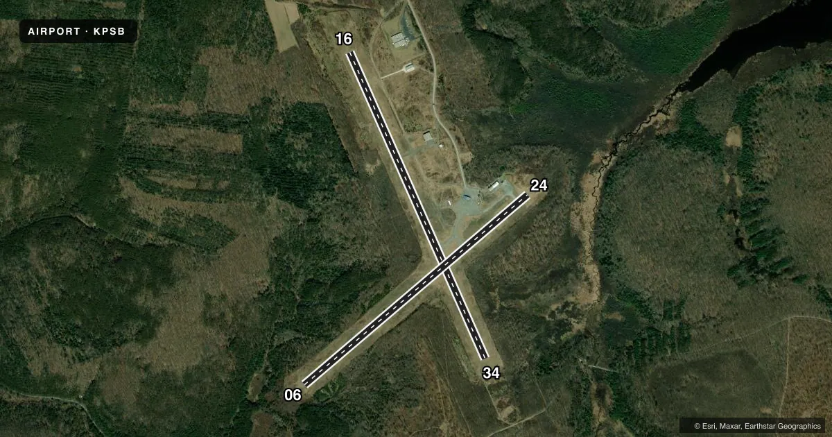
Airport sketch
Runways drawn to scale from FAA survey coordinates, rendered over satellite imagery. Not for navigation.
Approaches & charts
Services on the field
Fuel grades, oxygen, maintenance, ramp storage and lighting — as declared to the FAA by the airport operator.
Fuel & services
- Fuel
- Not available
- Oxygen (bottled)
- Not available
- Oxygen (bulk)
- Not available
- Airframe repair
- Not available
- Power plant repair
- Not available
Ramp & ground
- Transient storage
- Tie-down
- Landing fee
- No fee published
- Customs
- Not available
- Lighting schedule
- SEE RMK
- Wind indicator
- Yes
- Segmented circle
- Yes
Fuel & FBOs
Cheapest 100LL and Jet A on the field and nearby. Always confirm with the FBO before taxi.
Airport notes
Surface conditions, obstructions, local procedures, lighting outages and other notes published with each FAA cycle.
General notes
- HEAVY GLIDER ACTIVITY DURING DALGT HRS, ALL ALTS, ON AND INVOF AIRPORT AND WITHIN 15 NM EAST AND SOUTH OF ARPT.
- FOR CD IF UNA TO CTC ON FSS FREQ, CTC NEW YORK ARTCC AT 631-468-1425.
- ARPT ACES LTD; CTC MGR TO COORD 814-342-1080.
- DEER ON & INVOF ARPT.
- CTC NG OPS 30.5/122.85/242.4
Lighting notes
- ACTVT MIRL RWY 06/24 & 16/34 - CTAF.
Approach & departure obstructions
- 06MARKINGS EXTREMELY FADED.
- 16MARKINGS EXTREMELY FADED.
- 24MARKINGS EXTREMELY FADED.
- 34MRKGS EXTRMLY FADED.
- 06RWY 24 CLOSED FOR NGT VISUAL APCH DUE TO OBSTNS.
Other notes
- THIS AIRPORT HAS BEEN SURVEYED BY THE NATIONAL GEODETIC SURVEY.
- EXISTENCE PREDATES REQMT FOR ANALYSIS.
- 06/24ASPH CRUMBLING AT INTXN OF RWYS CAUSING POTHOLES AND FOD.
- 16/34ASPH CRUMBLING AT INTXN OF RWYS CAUSING POTHOLES AND FOD.
VFR map & nearby airports
VFR sectional. Tap any ICAO chip to open that airport.
Key facts · KPSB
Answer card- ICAO
- KPSB
- Name
- MID-STATE
- Location
- PHILIPSBURG, PENNSYLVANIA
- Elevation
- 1,948 ft MSL
- Traffic pattern altitude
- 2,948 ft MSL (1,000 AGL)
- Control tower
- Non-towered (use CTAF)
- Total runways
- 2
- Longest runway
- 16/34 · 5,711 ft
- Published ILS approaches
- 0
- Published frequencies
- 1
- Magnetic variation
- 11°
- Current flight rules
- VFR
- Current wind
- 000° at 3 kt
- Favored runway now
- RWY 34
MID-STATE is in Philipsburg, Pennsylvania. The field elevation is 1,948 ft MSL. It has two asphalt runways. The longest is 16/34 at 5,711 ft. There is no control tower. CTAF is 122.9. No ILS approaches are published here. For a light piston, the pattern altitude is not published in the source data. Use the standard 1,000 ft AGL unless the current Chart Supplement says otherwise.
This is a field where runway condition matters. The published remarks say the asphalt is crumbling at the 16/34 intersection. That can mean potholes and FOD. Markings on all runway ends are extremely faded. Runway 24 is also closed for night visual approach because of obstructions. Medium intensity runway lights on both runways are activated by CTAF.
Expect heavy glider activity during daylight hours at all altitudes on and near the airport. The activity extends within 15 NM east and south of the field. Airport access is limited. Call the manager at 814-342-1080 before you go. No on-field FBOs are listed in the facts, so verify fuel and services with the airport operator or on CTAF before arrival. The airport sits in central Pennsylvania terrain, so plan your descent and arrival with the elevation in mind.