METAR & TAF P96
P96 does not publish a METAR.
Showing the nearest reporting station: KIPT (WILLIAMSPORT RGNL) · 13.9 NM away. Conditions at P96 may differ.
METAR · KIPT
Observed 11:54Z
KIPT 271154Z 27006KT 10SM CLR 20/17 A2987 RMK AO2 SLP111 T02000167 10200 20172 51010 $
- Wind
- 270° @ 6 kt
- Visibility
- 10 SM
- Temp / Dew
- 20°C / 17°C
- Altimeter
- 29.87 inHg
- Clouds
- CLR
- Density alt
- 1,349 ft
- Ceiling
- Unlimited
- Rules
- VFR
Airport info & contacts
Manager on record, flight service, ARTCC, attendance schedule and pattern altitude — published by the FAA and refreshed every 28 days.
Location
- From city
- 2 NM E
- VFR sectional
- DETROIT
- ARTCC
- ZNY · NEW YORK
- NOTAM facility
- IPT (NOTAM-D)
Airport manager
- Name
- JOYCE HENNIGAN
- Phone
- 570-321-1408
- Address
- 1181 PINE CREEK AVE, JERSEY SHORE PA 17740
Flight service · Hours
- FSS IPT
- WILLIAMSPORT1-800-WX-BRIEF
- Attendance
- ON CALL
Frequencies
Tap any row to copy the frequency to your clipboard.
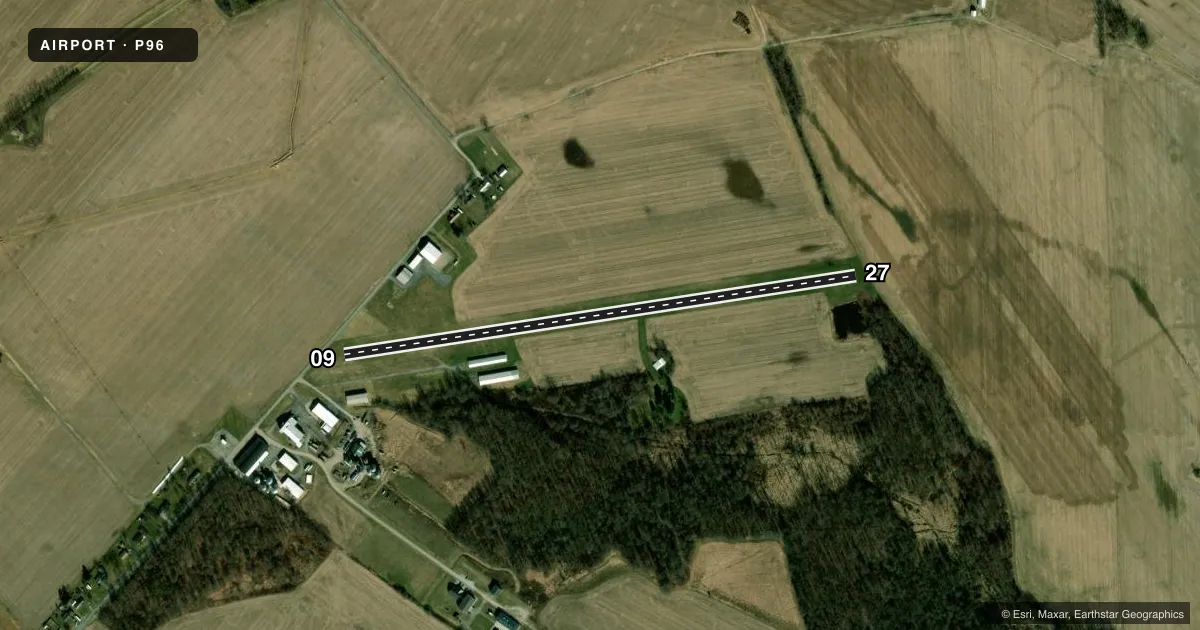
Runways & pattern
Full pagePattern entry · RWY 27
LEFT TRAFFICRunway end performance
| End | TORA | TODA | ASDA | LDA | VGSI | Approach lights | Obstruction |
|---|---|---|---|---|---|---|---|
| 09 | — | — | — | — | — | — | 17', road, 149' from thr, 21' R of cntrln, slope 8 |
| 27 | — | — | — | — | — | — | 10', brush, 38' from thr, 100' R of cntrln, slope 3 |
Declared distances in feet. TORA = takeoff run available, TODA = takeoff distance, ASDA = accelerate-stop, LDA = landing distance.
Airport sketch
Runways drawn to scale from FAA survey coordinates, rendered over satellite imagery. Not for navigation.
Approaches & charts
Services on the field
Fuel grades, oxygen, maintenance, ramp storage and lighting — as declared to the FAA by the airport operator.
Fuel & services
- Fuel
- Not available
- Oxygen (bottled)
- Not available
- Oxygen (bulk)
- Not available
- Airframe repair
- Not available
- Power plant repair
- Not available
Ramp & ground
- Transient storage
- Tie-down
- Hangar
- Landing fee
- No fee published
- Customs
- Not available
- Wind indicator
- Lighted
- Segmented circle
- No
Fuel & FBOs
Cheapest 100LL and Jet A on the field and nearby. Always confirm with the FBO before taxi.
Airport notes
Surface conditions, obstructions, local procedures, lighting outages and other notes published with each FAA cycle.
General notes
- DEER ON & INVOF ARPT.
- PARL TWY ADJ RWY 09/27 CLSD.
- FOR CD CTC NEW YORK ARTCC AT 631-468-1425.
Approach & departure obstructions
- 09APCH SLOPE 20:1 TO DTHR.
Other notes
- MANAGER570-279-1025.
VFR map & nearby airports
VFR sectional. Tap any ICAO chip to open that airport.
Key facts · P96
Answer card- ICAO
- P96
- Name
- JERSEY SHORE
- Location
- JERSEY SHORE, PENNSYLVANIA
- Elevation
- 554 ft MSL
- Traffic pattern altitude
- 1,554 ft MSL (1,000 AGL)
- Control tower
- Non-towered (use CTAF)
- Total runways
- 1
- Longest runway
- 09/27 · 3,059 ft
- Published ILS approaches
- 0
- Published frequencies
- 2
- Magnetic variation
- 11°
- Current flight rules
- VFR
- Current wind
- 270° at 6 kt
- Favored runway now
- RWY 27
Jersey Shore Airport is in Jersey Shore, Pennsylvania. The field elevation is 554 ft MSL. It has one runway, 09/27, which is 3,059 ft of turf. There is no control tower. CTAF and UNICOM are both 122.7.
No ILS approaches are published here. The pattern altitude is not published, so use the standard 1,000 ft AGL for light piston operations unless current local guidance says otherwise. The runway is magnetic 09/27. Published remarks note a 20:1 approach slope to the displaced threshold on runway 09. The parallel taxiway next to 09/27 is closed, so plan ground movement carefully and verify the current layout before taxiing.
There are no on-field FBOs listed. Contact the airport operator directly before arrival, or call the field on CTAF or UNICOM for current fuel and service availability. Deer are reported on and near the airport, so keep a sharp scan on departure and in the pattern. If you need clearance delivery, New York ARTCC is listed in the remarks. For any current operational detail that is not in the charted remarks, check the current FAA Chart Supplement or call the airport operator.