METAR & TAF N27
N27 does not publish a METAR.
Showing the nearest reporting station: KELM (ELMIRA/CORNING RGNL) · 32.1 NM away. Conditions at N27 may differ.
METAR · KELM
Observed 10:57Z
KELM 271057Z 00000KT 3SM BR OVC003 17/17 A2987 RMK AO2 T01670167
- Wind
- 000° @ 0 kt
- Visibility
- 3 SM
- Temp / Dew
- 17°C / 17°C
- Altimeter
- 29.87 inHg
- Clouds
- OVC
- Density alt
- 1,208 ft
- Ceiling
- 300 ft AGL
- Rules
- LIFR
Airport info & contacts
Manager on record, flight service, ARTCC, attendance schedule and pattern altitude — published by the FAA and refreshed every 28 days.
Location
- From city
- 2 NM S
- VFR sectional
- NEW YORK
- ARTCC
- ZNY · NEW YORK
- NOTAM facility
- IPT (NOTAM-D)
Airport manager
- Name
- SCOTT HAUSER
- Phone
- 570-265-4900
- Address
- 415 AIRPORT RD., TOWANDA PA 18848
Flight service · Hours
- FSS IPT
- WILLIAMSPORT1-800-WX-BRIEF
- Attendance
- M-F · 0800-1700
- NOV-FEB · SAT-SUN · UNATTENDED
- MAR-OCT · SAT-SUN · 0800-1600
Frequencies
Tap any row to copy the frequency to your clipboard.
Runways & pattern
Full pagePattern entry · RWY 05
LEFT TRAFFICRunway end performance
| End | TORA | TODA | ASDA | LDA | VGSI | Approach lights | Obstruction |
|---|---|---|---|---|---|---|---|
| 05 | — | — | — | — | PAPI 2-box left(3°) | — | — |
| 23 | — | — | — | — | PAPI 2-box left(3°) | — | — |
Declared distances in feet. TORA = takeoff run available, TODA = takeoff distance, ASDA = accelerate-stop, LDA = landing distance.
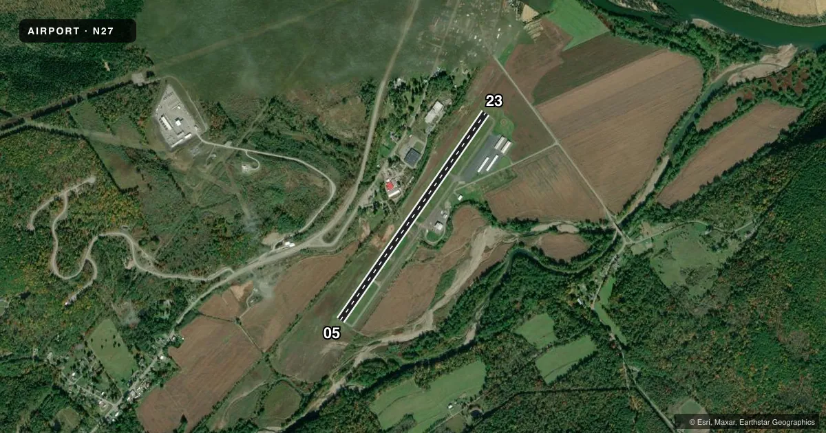
Airport sketch
Runways drawn to scale from FAA survey coordinates, rendered over satellite imagery. Not for navigation.
Approaches & charts
Services on the field
Fuel grades, oxygen, maintenance, ramp storage and lighting — as declared to the FAA by the airport operator.
Fuel & services
- Fuel
- 100LLA
- Oxygen (bottled)
- Not available
- Oxygen (bulk)
- Not available
- Airframe repair
- Major
- Power plant repair
- Major
- Other services
- INSTR
Ramp & ground
- Transient storage
- Tie-down
- Hangar
- Landing fee
- No fee published
- Customs
- Not available
- Lighting schedule
- SEE RMK
- Beacon schedule
- SS-SR
- Beacon
- White / Green (civil land)(WG)
- Wind indicator
- Lighted
- Segmented circle
- Yes
Fuel & FBOs
Cheapest 100LL and Jet A on the field and nearby. Always confirm with the FBO before taxi.
Airport notes
Surface conditions, obstructions, local procedures, lighting outages and other notes published with each FAA cycle.
General notes
- FOR CD CTC BINGHAMTON APCH AT 607-729-6146. WHEN APCH CLSD, CTC NEW YORK ARTCC AT 631-468-1425.
Lighting notes
- ACTVT REIL RWY 05 & 23; PAPI RWY 05 & 23; MIRL RWY 05/23 - CTAF.
Other notes
- ACFT OWNER SUP OWN TIE-DOWNS.
- 1FOR SVC AFT HRS CALL 570-637-4902.
VFR map & nearby airports
VFR sectional. Tap any ICAO chip to open that airport.
Key facts · N27
Answer card- ICAO
- N27
- Name
- BRADFORD COUNTY
- Location
- TOWANDA, PENNSYLVANIA
- Elevation
- 730.3 ft MSL
- Traffic pattern altitude
- 1,730.3 ft MSL (1,000 AGL)
- Control tower
- Non-towered (use CTAF)
- Total runways
- 1
- Longest runway
- 05/23 · 4,301 ft
- Published ILS approaches
- 0
- Published frequencies
- 4
- Magnetic variation
- 12°
- Current flight rules
- LIFR
- Current wind
- 000° at 0 kt
- Favored runway now
- –
Bradford County Airport sits in Towanda, Pennsylvania. Field elevation is 730.3 ft MSL. The airport has one runway, 05/23 and it is 4,301 ft long. There is no control tower. Pattern altitude is not published, so use the standard 1,000 ft AGL for light piston traffic unless the current Chart Supplement says otherwise.
No ILS approaches are published here. The field uses Binghamton Approach for clearance delivery and approach services when available. CTAF and UNICOM are both 123.0. Runway end identifier lights are installed on 05 and 23. Precision approach path indicators are also installed on both runway ends. Medium intensity runway lights are on 05/23 and are controlled by CTAF.
The on-field FBO is Bradford County Airport. It carries 100LL and Jet A. Call the FBO directly at (570) 265-4900 for current service details. Published remarks also note after-hours service at 570-637-4902. Aircraft owners supply their own tie-downs, so plan for that before you arrive.
For a first-time arrival, the main things to brief are the non-towered pattern, the published lighting setup and the approach handoff to Binghamton. Check the current Chart Supplement for any changes before you go.