METAR & TAF KDSV
Current METAR
Observed 12:54Z
KDSV 271254Z AUTO 15006KT 10SM OVC025 21/17 A2988 RMK AO2 SLP123 T02110172
- Wind
- 150° @ 6 kt
- Visibility
- 10 SM
- Temp / Dew
- 21°C / 17°C
- Altimeter
- 29.88 inHg
- Clouds
- OVC
- Density alt
- 1,588 ft
- Ceiling
- 2,500 ft AGL
- Rules
- MVFR
Airport info & contacts
Manager on record, flight service, ARTCC, attendance schedule and pattern altitude — published by the FAA and refreshed every 28 days.
Location
- From city
- 1 NM NW
- VFR sectional
- DETROIT
- ARTCC
- ZOB · CLEVELAND
- NOTAM facility
- DSV (NOTAM-D)
Airport manager
- Name
- RICK LAFFORD
- Phone
- 585-451-3316
- Address
- 176 FRANKLIN STREET, DANSVILLE NY 14437
Flight service · Hours
- FSS BUF
- BUFFALO1-800-WX-BRIEF
- Attendance
- MON - FRI · 0900-1630
Frequencies
Tap any row to copy the frequency to your clipboard.
Runways & pattern
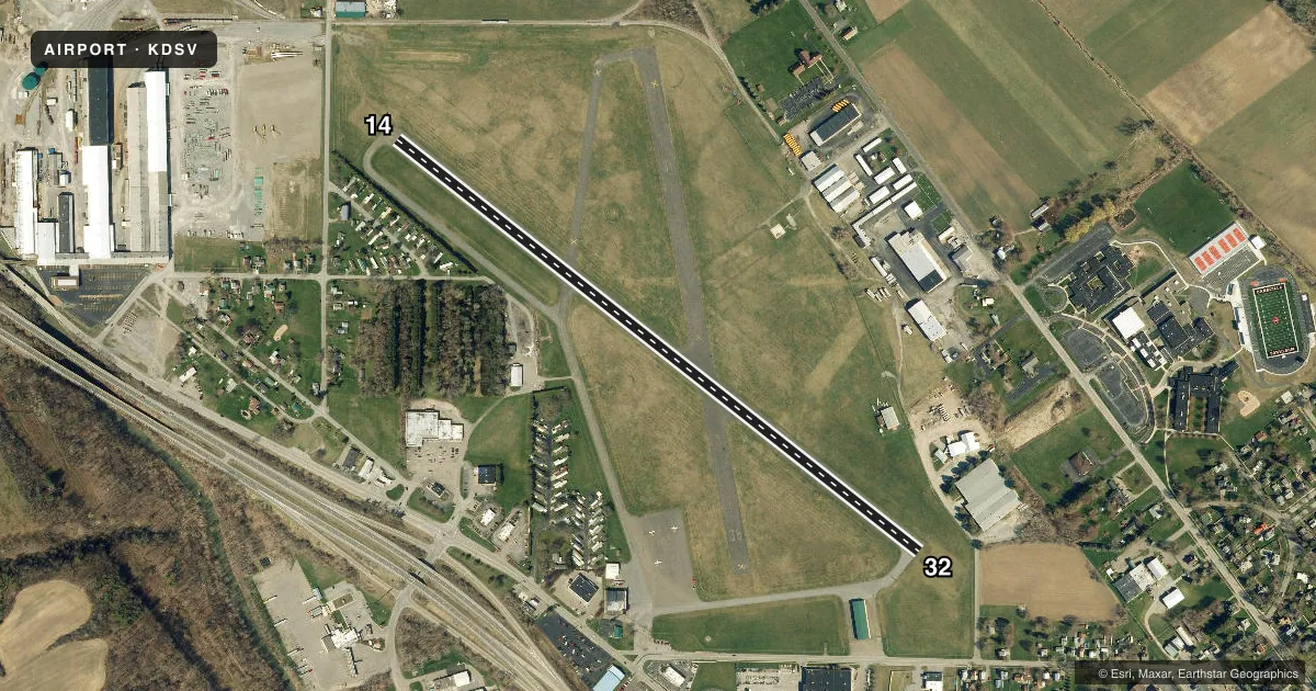
Full pagePattern entry · RWY 14
LEFT TRAFFICRunway end performance
| End | TORA | TODA | ASDA | LDA | VGSI | Approach lights | Obstruction |
|---|---|---|---|---|---|---|---|
| 14 | — | — | — | — | VASI 2-box left(3°) | — | 6', fence, 215' from thr, 250' R of cntrln, slope 2 |
| 32 | — | — | — | — | VASI 4-box left(4°) | — | 15', road, 201' from thr, 200' R of cntrln, slope 0 |
Declared distances in feet. TORA = takeoff run available, TODA = takeoff distance, ASDA = accelerate-stop, LDA = landing distance.
Airport sketch
Runways drawn to scale from FAA survey coordinates, rendered over satellite imagery. Not for navigation.
Approaches & charts
Services on the field
Fuel grades, oxygen, maintenance, ramp storage and lighting — as declared to the FAA by the airport operator.
Fuel & services
- Fuel
- 100LL
- Oxygen (bottled)
- Not available
- Oxygen (bulk)
- Not available
- Airframe repair
- Not available
- Power plant repair
- Not available
- Other services
- GLD,INSTR,TOW
Ramp & ground
- Transient storage
- Tie-down
- Hangar
- Landing fee
- No fee published
- Customs
- Not available
- Lighting schedule
- SEE RMK
- Beacon schedule
- SS-SR
- Beacon
- White / Green (civil land)(WG)
- Wind indicator
- Lighted
- Segmented circle
- Yes
Fuel & FBOs
Cheapest 100LL and Jet A on the field and nearby. Always confirm with the FBO before taxi.
Airport notes
Surface conditions, obstructions, local procedures, lighting outages and other notes published with each FAA cycle.
General notes
- EXTSV GLIDER ACTVTY. GLIDER USE RIGHT PAT FOR THE TURF AREA RIGHT OF RWY 32 & LEFT PAT FOR THE TURF AREA LEFT OF RWY 14.
- FOR CD CTC CLEVELAND ARTCC AT 440-774-0490.
- RWY 14 90 FT RELCTD THLD.
Lighting notes
- ACTVT VASI RWY 14 & 32; MIRL RWY 14/32 - CTAF.
Fuel notes
- 100LL24 HR SELF SVC.
Runway surface & condition
- 14/32MIN SFC AND BASE REQRMTS NOT MET FOR DUAL AND DUAL TANDEM GWTS RWY 14-32.
Approach & departure obstructions
- 32ACES ROAD W/FENCE 230 FT RIGHT.
- 144 FT FENCE & 40 FT TREES IN THE APCH.
- 14RWY 14, 15 FT RD, 220 FT DSTC, 250 FT R; 35 FT POLE, 282 FT DSTC, 262 FT R, 2:1; 60 FT UNLGTD CRANES, 700 FT DSTC.
Other notes
- EXISTED PRIOR TO 1959.
- MANAGERAMGR CELL 585-451-3316
VFR map & nearby airports
VFR sectional. Tap any ICAO chip to open that airport.
Key facts · KDSV
Answer card- ICAO
- KDSV
- Name
- DANSVILLE MUNI
- Location
- DANSVILLE, NEW YORK
- Elevation
- 659.8 ft MSL
- Traffic pattern altitude
- 1,659.8 ft MSL (1,000 AGL)
- Control tower
- Non-towered (use CTAF)
- Total runways
- 1
- Longest runway
- 14/32 · 3,500 ft
- Published ILS approaches
- 0
- Published frequencies
- 4
- Magnetic variation
- 9°
- Current flight rules
- MVFR
- Current wind
- 150° at 6 kt
- Favored runway now
- RWY 14
Dansville Muni is in Dansville, New York. The field elevation is 659.8 ft MSL. It has one runway. Runway 14/32 is 3,500 ft long and asphalt. There is no control tower, so expect non-towered traffic flow on CTAF 123.0. No ILS approaches are published here.
Pattern altitude is not published. Use 1,000 ft AGL for light piston operations unless local procedures or ATC say otherwise. The airport has a lot of glider activity. Gliders use right traffic for the turf area right of runway 32. They use left traffic for the turf area left of runway 14. That matters when you are joining the pattern.
Runway 14 has a relocated threshold. Published remarks also call out obstructions near runway 14, including a road, a pole, cranes, a fence and trees. Runway 32 has Aces Road with a fence off to the right. The runway lights are medium intensity and are controlled on CTAF. VASI lights are available for both runway 14 and runway 32. 100LL is available 24 hours by self-serve. There is no on-field FBO listed, so verify services with the airport operator or the field directly before you go. For clearance delivery, contact Cleveland ARTCC.