METAR & TAF 4N2
4N2 does not publish a METAR.
Showing the nearest reporting station: KPEO (PENN YAN/YATES COUNTY) · 10.7 NM away. Conditions at 4N2 may differ.
METAR · KPEO
Observed 22:53Z
KPEO 262253Z AUTO 00000KT 10SM BKN065 25/18 A2986 RMK AO2 LTG DSNT SE SLP103 T02500183
- Wind
- 000° @ 0 kt
- Visibility
- 10 SM
- Temp / Dew
- 25°C / 18°C
- Altimeter
- 29.86 inHg
- Clouds
- BKN
- Density alt
- 2,229 ft
- Ceiling
- 6,500 ft AGL
- Rules
- VFR
Airport info & contacts
Manager on record, flight service, ARTCC, attendance schedule and pattern altitude — published by the FAA and refreshed every 28 days.
Location
- From city
- 1 NM NW
- VFR sectional
- DETROIT
- ARTCC
- ZOB · CLEVELAND
- NOTAM facility
- BUF (NOTAM-D)
Airport manager
- Name
- ROBERT MINCER
- Phone
- (585) 465-3926
- Address
- 1078 LINCOLN AVE, MIDDLESEX NY 14507
Flight service · Hours
- FSS BUF
- BUFFALO1-800-WX-BRIEF
- Attendance
- SR-SS
Frequencies
Tap any row to copy the frequency to your clipboard.
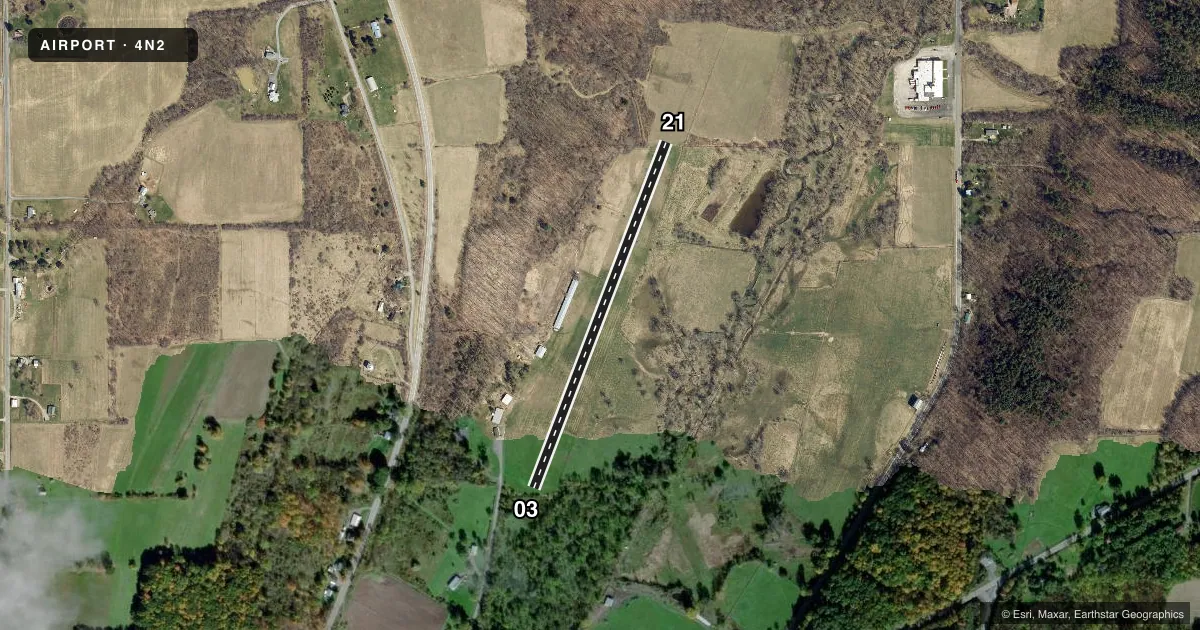
Runways & pattern
Full pagePattern entry · RWY 03
LEFT TRAFFICRunway end performance
| End | TORA | TODA | ASDA | LDA | VGSI | Approach lights | Obstruction |
|---|---|---|---|---|---|---|---|
| 03 | — | — | — | — | — | — | 19', brush, 24' from thr, 32' R of cntrln, slope 1 |
| 21 | — | — | — | — | — | — | 111', tree, 882' from thr, 15' R of cntrln, slope 7 |
Declared distances in feet. TORA = takeoff run available, TODA = takeoff distance, ASDA = accelerate-stop, LDA = landing distance.
Airport sketch
Runways drawn to scale from FAA survey coordinates, rendered over satellite imagery. Not for navigation.
Approaches & charts
Services on the field
Fuel grades, oxygen, maintenance, ramp storage and lighting — as declared to the FAA by the airport operator.
Fuel & services
- Fuel
- Not available
- Airframe repair
- Minor
- Power plant repair
- Minor
Ramp & ground
- Transient storage
- Not published
- Wind indicator
- Yes
- Segmented circle
- No
Fuel & FBOs
Cheapest 100LL and Jet A on the field and nearby. Always confirm with the FBO before taxi.
Airport notes
Surface conditions, obstructions, local procedures, lighting outages and other notes published with each FAA cycle.
General notes
- +4 FT HIGH FENCE LCTD ALG E EDGE OF RY, 88 FT FM CNTRLN.
- FOR CD CTC CLEVELAND ARTCC AT 440-774-0490.
Runway surface & condition
- 03/21RY 03/21 NOT PLOWED IN WINTER.
Other notes
- PROVIDED VFR USE.
- 03/21CALL AMGR FOR FICON 585-465-3926.
VFR map & nearby airports
VFR sectional. Tap any ICAO chip to open that airport.
Key facts · 4N2
Answer card- ICAO
- 4N2
- Name
- MIDDLESEX VALLEY
- Location
- MIDDLESEX, NEW YORK
- Elevation
- 770 ft MSL
- Traffic pattern altitude
- 1,770 ft MSL (1,000 AGL)
- Control tower
- Non-towered (use CTAF)
- Total runways
- 1
- Longest runway
- 03/21 · 2,130 ft
- Published ILS approaches
- 0
- Published frequencies
- 2
- Magnetic variation
- 12°
- Current flight rules
- VFR
- Current wind
- 000° at 0 kt
- Favored runway now
- –
Middlesex Valley Airport sits in Middlesex, New York. The field elevation is 770 ft MSL. It has one runway. Runway 03/21 is 2,130 ft of turf, so plan for a short-field, grass-strip arrival and departure. No control tower is published here. CTAF and UNICOM are both 122.7.
No ILS approaches are published. This is a VFR-use field. Pattern altitude is not published in the facts, so use the standard 1,000 ft AGL unless current airport information says otherwise. That puts the traffic pattern at 1,770 ft MSL based on the listed field elevation.
Published remarks matter here. Runway 03/21 is not plowed in winter. There is also a 4-foot fence along the east edge of the runway, 88 ft from the centerline. Call the airport manager at 585-465-3926 for field condition information before you go. For clearance delivery, contact Cleveland ARTCC at 440-774-0490. With one turf runway and no published instrument approach, a first-time pilot should verify surface condition, wind and landing distance carefully before committing.