METAR & TAF KPEO
Current METAR
Observed 12:53Z
KPEO 271253Z AUTO 18005KT 10SM CLR 21/17 A2987 RMK AO2 SLP108 T02110172
- Wind
- 180° @ 5 kt
- Visibility
- 10 SM
- Temp / Dew
- 21°C / 17°C
- Altimeter
- 29.87 inHg
- Clouds
- CLR
- Density alt
- 2,007 ft
- Ceiling
- Unlimited
- Rules
- VFR
Airport info & contacts
Manager on record, flight service, ARTCC, attendance schedule and pattern altitude — published by the FAA and refreshed every 28 days.
Location
- From city
- 1 NM S
- VFR sectional
- DETROIT
- ARTCC
- ZNY · NEW YORK
- NOTAM facility
- PEO (NOTAM-D)
Airport manager
- Name
- RICHARD LEPPERT
- Phone
- 315-536-4471
- Address
- 2262 AIRPORT DR., PENN YAN NY 14527
Flight service · Hours
- FSS BUF
- BUFFALO1-800-WX-BRIEF
- Attendance
- MON-FRI · 0800-1700
- SAT · 0900-1500
- SUN · 0900-1500
Frequencies
Tap any row to copy the frequency to your clipboard.
Runways & pattern
Full pagePattern entry · RWY 19
LEFT TRAFFIC| Runway | Heading (°M) | Length | Surface | Traffic |
|---|---|---|---|---|
| 01/19Favored | 345° / 165° | 5,499 ft | ASPH | Standard L |
| 10/28 | 76° / 256° | 3,561 ft | ASPH | Standard L |
Runway end performance
| End | TORA | TODA | ASDA | LDA | VGSI | Approach lights | Obstruction |
|---|---|---|---|---|---|---|---|
| 01 | — | — | — | — | PAPI 2-box left(3°) | — | 129', fence, 2255' from thr, 144' R of cntrln, slope 15 |
| 19 | — | — | — | — | PAPI 2-box left(3°) | — | 42', trees, 1404' from thr, 234' R of cntrln, slope 28 |
| 10 | — | — | — | — | PAPI 2-box left(3°) | — | 20', pole, 215' from thr, 124' R of cntrln, slope 0 |
| 28 | — | — | — | — | PAPI 2-box right(3.5°) | — | 68', pole, 556' from thr, 108' R of cntrln, slope 5 |
Declared distances in feet. TORA = takeoff run available, TODA = takeoff distance, ASDA = accelerate-stop, LDA = landing distance.
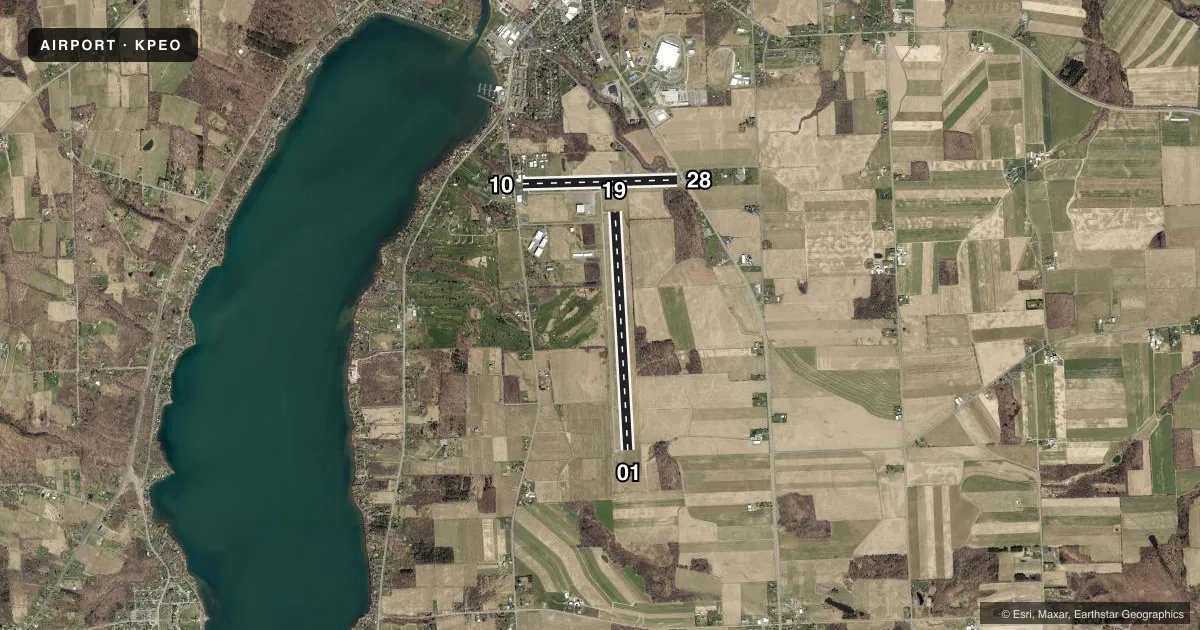
Airport sketch
Runways drawn to scale from FAA survey coordinates, rendered over satellite imagery. Not for navigation.
Approaches & charts
Services on the field
Fuel grades, oxygen, maintenance, ramp storage and lighting — as declared to the FAA by the airport operator.
Fuel & services
- Fuel
- 100LLA
- Oxygen (bottled)
- HIGH/LOW
- Oxygen (bulk)
- Not available
- Airframe repair
- Major
- Power plant repair
- Major
- Other services
- AFRT,CHTR,INSTR
Ramp & ground
- Transient storage
- Tie-down
- Hangar
- Landing fee
- No fee published
- Customs
- Not available
- Lighting schedule
- SEE RMK
- Beacon schedule
- SS-SR
- Beacon
- White / Green (civil land)(WG)
- Wind indicator
- Yes
- Segmented circle
- No
Fuel & FBOs
Cheapest 100LL and Jet A on the field and nearby. Always confirm with the FBO before taxi.
Airport notes
Surface conditions, obstructions, local procedures, lighting outages and other notes published with each FAA cycle.
General notes
- ADF APCH RWY 10/28 TRANSITIONARY AT 700'.
- FOR CD CTC ELMYRA APCH AT 607-739-1971, WHEN APCH CLSD CTC CLEVELAND ARTCC AT 440-774-0231.
- DUE TO TOPOGRAPHY, ACFT TO ACFT GND COMS LTD. ACFT CANNOT BE SEEN OR HEARD ON OPPOSITE ENDS OF RWY 01/19. USE EXTRM CTN.
- TYPE I & TYPE IV DE-ICE AVBL.
- FBO LCTD CNTR FLD. LOBBY ACES 24/7.
Lighting notes
- ACTVT PAPI RWY 01, 19, 10, 28; MIRL RWY 01/19; LIRL RWY 10/28 - CTAF.
Fuel notes
- 100LLSELF SVC AVBL 24/7.
Runway surface & condition
- 10/28THE PAVEMENT SECTION FOR RWY 10/28 IS GREATER THAN THE REQUIRED THICKNESS FOR THE FLEET OF AIRCRAFT THAT CURRENTLY UTILIZE THE RWY. THE PCN LISTED IS THE LARGEST AIRCRAFT CLASSIFICATION NUMBER FOR THE CURRENT AIRCRAFT USING RUNWAY 10/28.
Approach & departure obstructions
- 10RWY 10 HAS +16 FT BLDG 59 FT FROM RWY END 95 FT LT; +14 FT BLDG, 123 FT FROM RWY, 60 FT LT; +8 FT FENCE 18 FT FROM RWY END BOTH SIDES AND CENTER.
- 2849 FT TREE; 8 FT FM RWY END, 239 FT RIGHT. 13 FT FENCE; 13 FT FM RWY END, BOTH SIDES.
- 10CTLNG OBSTN EXCEEDS 45 DEG SLP.
- 28RWY 28 APCH RATIO 13:1 TO DTHR.
Other notes
- HELICOPTER AIRFRAME REPAIRS
- EXISTED PRIOR TO 1959
- CHTRCPU, LAV
VFR map & nearby airports
VFR sectional. Tap any ICAO chip to open that airport.
Key facts · KPEO
Answer card- ICAO
- KPEO
- Name
- PENN YAN/YATES COUNTY
- Location
- PENN YAN, NEW YORK
- Elevation
- 988 ft MSL
- Traffic pattern altitude
- 1,988 ft MSL (1,000 AGL)
- Control tower
- Non-towered (use CTAF)
- Total runways
- 2
- Longest runway
- 01/19 · 5,499 ft
- Published ILS approaches
- 0
- Published frequencies
- 4
- Magnetic variation
- 12°
- Current flight rules
- VFR
- Current wind
- 180° at 5 kt
- Favored runway now
- RWY 19
Penn Yan/Yates County Airport sits in Penn Yan, New York. Field elevation is 988 ft MSL. The airport has two asphalt runways. The longest is 01/19 at 5,499 ft. Runway 10/28 is 3,561 ft. There is no control tower. CTAF and UNICOM are both 123.0. Approach and departure service is on 124.3 or 257.8 with Elmira. No ILS approaches are published here.
Pattern altitude is not published. Use the standard 1,000 ft AGL for light piston traffic unless the current Chart Supplement says otherwise. That puts the traffic pattern at about 1,988 ft MSL at this field elevation. Seneca Flight Operations is on the field. It carries 100LL and Jet A. Self-serve 100LL is available 24 hours a day, 7 days a week. The lobby is also open 24 hours a day, 7 days a week.
This is a field where terrain matters. The published remarks say aircraft-to-aircraft ground communications can be limited because of topography. Aircraft cannot be seen or heard on opposite ends of runway 01/19. Use extra caution on the ground and in the pattern. Runway 10 has close-in obstacles near the departure end. Runway 28 has a tree and fence near the threshold area. There is also a published 13:1 clearance slope to the displaced threshold. Helicopter airframe repairs are available. Charter service includes CPU and lavatory.