METAR & TAF KAXQ
KAXQ does not publish a METAR.
Showing the nearest reporting station: KFKL (VENANGO RGNL) · 21.0 NM away. Conditions at KAXQ may differ.
METAR · KFKL
Observed 12:56Z
KFKL 271256Z AUTO 26005KT 10SM CLR 21/19 A2992 RMK AO2 SLP125 T02110194
- Wind
- 260° @ 5 kt
- Visibility
- 10 SM
- Temp / Dew
- 21°C / 19°C
- Altimeter
- 29.92 inHg
- Clouds
- CLR
- Density alt
- 2,527 ft
- Ceiling
- Unlimited
- Rules
- VFR
Airport info & contacts
Manager on record, flight service, ARTCC, attendance schedule and pattern altitude — published by the FAA and refreshed every 28 days.
Location
- From city
- 3 NM NW
- VFR sectional
- DETROIT
- ARTCC
- ZOB · CLEVELAND
- NOTAM facility
- AOO (NOTAM-D)
Airport manager
- Name
- WILLIAM GUTH
- Phone
- (814) 226-9993
- Address
- 395 AIRPORT ROAD, SHIPPENVILLE PA 16254
Flight service · Hours
- FSS AOO
- ALTOONA1-800-WX-BRIEF
- Attendance
- MON-FRI · 0830-1600
Frequencies
Tap any row to copy the frequency to your clipboard.
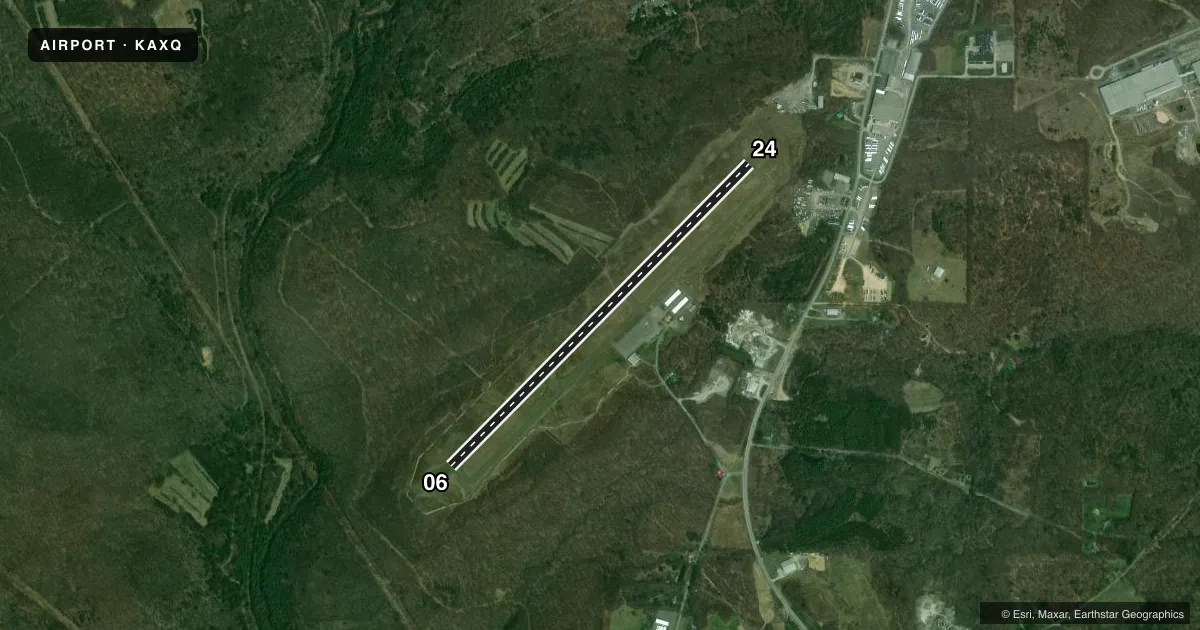
Runways & pattern
Full pagePattern entry · RWY 24
LEFT TRAFFICRunway end performance
| End | TORA | TODA | ASDA | LDA | VGSI | Approach lights | Obstruction |
|---|---|---|---|---|---|---|---|
| 06 | — | — | — | — | PAPI 2-box left(3°) | — | 12', trees, 505' from thr, 257' R of cntrln, slope 25 |
| 24 | — | — | — | — | PAPI 2-box left(3°) | — | 44', trees, 851' from thr, 329' R of cntrln, slope 14 |
Declared distances in feet. TORA = takeoff run available, TODA = takeoff distance, ASDA = accelerate-stop, LDA = landing distance.
Airport sketch
Runways drawn to scale from FAA survey coordinates, rendered over satellite imagery. Not for navigation.
Approaches & charts
Services on the field
Fuel grades, oxygen, maintenance, ramp storage and lighting — as declared to the FAA by the airport operator.
Fuel & services
- Fuel
- 100LLA+
- Oxygen (bottled)
- Not available
- Oxygen (bulk)
- Not available
- Other services
- INSTR,RNTL
Ramp & ground
- Transient storage
- Tie-down
- Hangar
- Landing fee
- Yes
- Lighting schedule
- SEE RMK
- Beacon schedule
- SS-SR
- Beacon
- White / Green (civil land)(WG)
- Wind indicator
- Lighted
- Segmented circle
- No
Fuel & FBOs
Cheapest 100LL and Jet A on the field and nearby. Always confirm with the FBO before taxi.
Airport notes
Surface conditions, obstructions, local procedures, lighting outages and other notes published with each FAA cycle.
General notes
- FOR CD CTC CLEVELAND ARTCC AT 440-774-0234/0442.
Lighting notes
- ACTVT MIRL RY 06/24, REIL RYS 06 & 24 AND PAPI RYS 06 & 24 - CTAF.
Fuel notes
- 100LLSNGL POINT RFLNG AVBL UPON REQ. JET A WITH PRIST AVBL SELF SVC 24 HRS. 100 LL AVBL SELF SVC 24 HRS.
Other notes
- THIS AIRPORT HAS BEEN SURVEYED BY THE NATIONAL GEODETIC SURVEY.
- 1UNATNDD MEML DAY, JULY 4TH, LABOR DAY, THANKSGIVING, CHRISTMAS, AND NEW YEARS DAY.
VFR map & nearby airports
VFR sectional. Tap any ICAO chip to open that airport.
Key facts · KAXQ
Answer card- ICAO
- KAXQ
- Name
- CLARION COUNTY
- Location
- CLARION, PENNSYLVANIA
- Elevation
- 1,457.5 ft MSL
- Traffic pattern altitude
- 2,457.5 ft MSL (1,000 AGL)
- Control tower
- Non-towered (use CTAF)
- Total runways
- 1
- Longest runway
- 06/24 · 5,003 ft
- Published ILS approaches
- 0
- Published frequencies
- 2
- Magnetic variation
- 10°
- Current flight rules
- VFR
- Current wind
- 260° at 5 kt
- Favored runway now
- RWY 24
Clarion County Airport sits in Clarion, Pennsylvania. The field elevation is 1,457.5 ft MSL. It has one runway, 06/24, which is 5,003 ft long and paved with asphalt. There is no control tower. Use CTAF 122.8 for traffic and UNICOM 122.8 for local coordination.
No ILS approaches are published here. The pattern altitude is not published, so plan on the standard 1,000 ft AGL for light piston traffic unless the current FAA Chart Supplement says otherwise. The runway lighting is medium intensity. Runway end identifier lights are installed on 06 and 24. PAPI is available on both ends. That helps for night work or marginal VFR.
Clarion County Airport Authority is on the field. It carries 100LL and Jet A with PRIST. 100LL and Jet A with PRIST are available self-service 24 hours. Single-point refueling is also available upon request. The airport is unattended on Memorial Day, July 4th, Labor Day, Thanksgiving, Christmas and New Year's Day.
This is a non-towered field at moderate elevation. Expect to self-announce clearly. Watch density altitude on warm days. For clearance delivery, Cleveland ARTCC can be reached by phone. If you need anything beyond the published basics, check the current FAA Chart Supplement or call the airport operator before you go.