METAR & TAF N35
N35 does not publish a METAR.
Showing the nearest reporting station: KDUJ (DUBOIS RGNL) · 12.8 NM away. Conditions at N35 may differ.
METAR · KDUJ
Observed 04:53Z
KDUJ 270453Z AUTO 00000KT 10SM FEW110 17/16 A2992 RMK AO2 SLP122 T01670161 402500144
- Wind
- 000° @ 0 kt
- Visibility
- 10 SM
- Temp / Dew
- 17°C / 16°C
- Altimeter
- 29.92 inHg
- Clouds
- FEW
- Density alt
- 2,032 ft
- Ceiling
- Unlimited
- Rules
- VFR
Airport info & contacts
Manager on record, flight service, ARTCC, attendance schedule and pattern altitude — published by the FAA and refreshed every 28 days.
Location
- From city
- 3 NM NE
- VFR sectional
- DETROIT
- ARTCC
- ZOB · CLEVELAND
- NOTAM facility
- AOO (NOTAM-D)
Airport manager
- Name
- RICK YOUNG
- Phone
- (814) 590-1137
- Address
- PO BOX 365, PUNXSUTAWNEY PA 15767
Flight service · Hours
- FSS AOO
- ALTOONA1-800-WX-BRIEF
- Attendance
- UNATTENDED
Frequencies
Tap any row to copy the frequency to your clipboard.
Runways & pattern
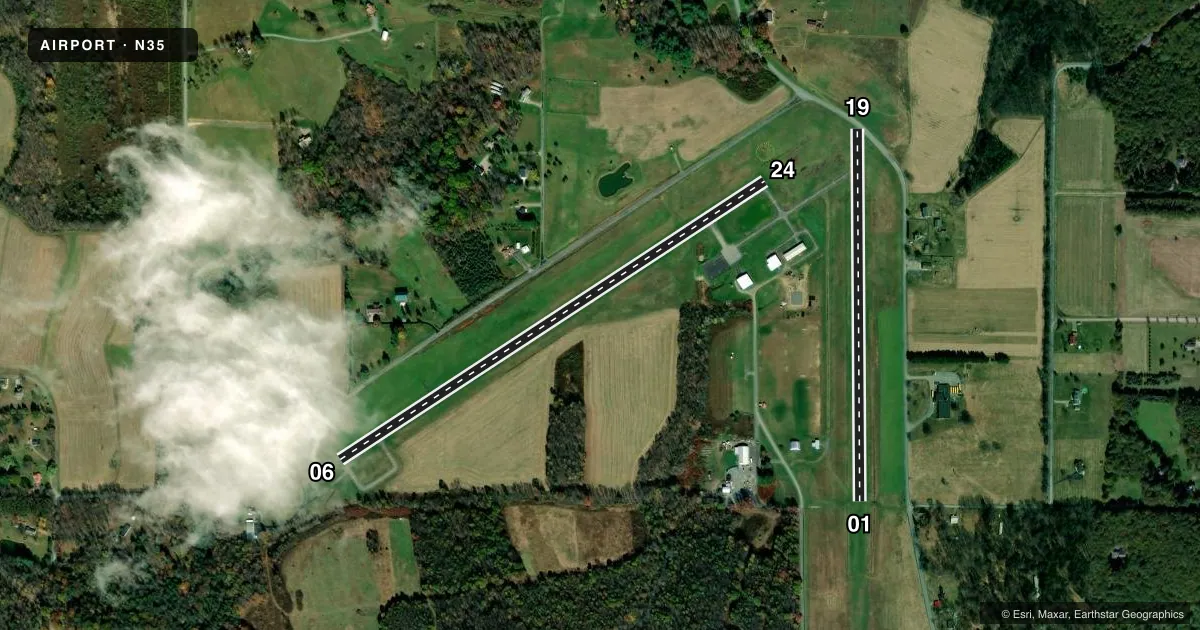
Full pagePattern entry · RWY 06
LEFT TRAFFIC| Runway | Heading (°M) | Length | Surface | Traffic |
|---|---|---|---|---|
| 06/24 | 47° / 227° | 3,003 ft | ASPH | Standard L |
| 01/19 | 350° / 170° | 2,200 ft | TURF | Standard L |
Runway end performance
| End | TORA | TODA | ASDA | LDA | VGSI | Approach lights | Obstruction |
|---|---|---|---|---|---|---|---|
| 06 | — | — | — | — | PAPI 2-box left(4°) | — | 32', trees, 297' from thr, 252' R of cntrln, slope 3 |
| 24 | — | — | — | — | PAPI 2-box left(4°) | — | 28', road, 634' from thr, 0' R of cntrln, slope 15 |
| 01 | — | — | — | — | — | — | 67', trees, 1001' from thr, 178' R of cntrln, slope 14 |
Declared distances in feet. TORA = takeoff run available, TODA = takeoff distance, ASDA = accelerate-stop, LDA = landing distance.
Airport sketch
Runways drawn to scale from FAA survey coordinates, rendered over satellite imagery. Not for navigation.
Approaches & charts
Services on the field
Fuel grades, oxygen, maintenance, ramp storage and lighting — as declared to the FAA by the airport operator.
Fuel & services
- Fuel
- 100LL
- Oxygen (bottled)
- Not available
- Oxygen (bulk)
- Not available
- Airframe repair
- Not available
- Power plant repair
- Not available
- Other services
- INSTR
Ramp & ground
- Transient storage
- Tie-down
- Hangar
- Landing fee
- No fee published
- Customs
- Not available
- Lighting schedule
- SEE RMK
- Beacon schedule
- SS-SR
- Beacon
- White / Green (civil land)(WG)
- Wind indicator
- Lighted
- Segmented circle
- Yes
Fuel & FBOs
Cheapest 100LL and Jet A on the field and nearby. Always confirm with the FBO before taxi.
Airport notes
Surface conditions, obstructions, local procedures, lighting outages and other notes published with each FAA cycle.
General notes
- TURF SOFT AND WET DRG SPRING THAW.
- 56 FT STACK E OF RWY 01
- RWY 01/19 CLSD DEC-APR.
- BIRDS; DEER & WOODCHUCK ON & INVOF ARPT.
- RWY 19 22 FT ROAD 146 FT FM RWY END ACRS CNTRLN.
- FOR CD CTC CLEVELAND ARTCC AT 440-774-0234.
- RWY 24 REIL IS ON A DAY SENSOR, OPER DURG HRS OF DARKNESS ONLY.
Lighting notes
- ACTVT REIL RWY 1 & 19, 06 & 24; PAPI RWY 06 & 24; MIRL RWY 01/19 & 06/24 - CTAF.
Fuel notes
- 100LLFUEL SELF-SERVE WITH CREDIT CARD.
Approach & departure obstructions
- 06RWY 06 30 FT POLE, 103 FT FM RWY END, 227 FT RIGHT.
- 01RWY MARKED WITH ORANGE CONES.
- 19RWY MARKED WITH ORANGE CONES.
Other notes
- VFR OPS ONLY.
- TSNT HNGR SPACE WITH PRIOR CDN.
- 1FOR SVC AFTER HRS CTC 814-590-1137.
VFR map & nearby airports
VFR sectional. Tap any ICAO chip to open that airport.
Key facts · N35
Answer card- ICAO
- N35
- Name
- PUNXSUTAWNEY MUNI
- Location
- PUNXSUTAWNEY, PENNSYLVANIA
- Elevation
- 1,444.8 ft MSL
- Traffic pattern altitude
- 2,444.8 ft MSL (1,000 AGL)
- Control tower
- Non-towered (use CTAF)
- Total runways
- 2
- Longest runway
- 06/24 · 3,003 ft
- Published ILS approaches
- 0
- Published frequencies
- 2
- Magnetic variation
- 10°
- Current flight rules
- VFR
- Current wind
- 000° at 0 kt
- Favored runway now
- –
Punxsutawney Muni sits in Punxsutawney, Pennsylvania. Field elevation is 1,444.8 ft MSL. The airport has two runways. The longest is 06/24 at 3,003 ft. Runway 01/19 is turf at 2,200 ft. There is no control tower. CTAF and UNICOM are both 123.0. No ILS approaches are published, so plan with VFR in mind. The published pattern altitude is not listed, so use the standard 1,000 ft AGL for light piston traffic unless the current Chart Supplement says otherwise.
The on-field FBO is Punxsutawney Municipal Airport. It carries 100LL. Fuel is self-serve with credit card. For after-hours service, the published number is 814-590-1137. The remarks matter here. Runway 01/19 is closed from December through April. Runway 19 has a road crossing 146 ft from the end, across the centerline. There is also a 56 ft stack east of runway 01. The turf can be soft and wet during spring thaw. Wildlife is a real factor too. Birds, deer and woodchuck are reported on and near the field. Runway 06/24 has PAPI, REIL and medium intensity lighting controlled by CTAF. Runway 24 REIL works only in darkness. This is a VFR-only airport. Check the current Chart Supplement before you go.