METAR & TAF KTHV
Current METAR
Observed 16:53Z
KTHV 271653Z AUTO 32006KT 10SM FEW047 SCT060 29/17 A2985 RMK AO2 SLP105 T02890172
- Wind
- 320° @ 6 kt
- Visibility
- 10 SM
- Temp / Dew
- 29°C / 17°C
- Altimeter
- 29.85 inHg
- Clouds
- SCT
- Density alt
- 2,380 ft
- Ceiling
- Unlimited
- Rules
- VFR
Airport info & contacts
Manager on record, flight service, ARTCC, attendance schedule and pattern altitude — published by the FAA and refreshed every 28 days.
Location
- From city
- 7 NM SW
- VFR sectional
- WASHINGTON
- ARTCC
- ZNY · NEW YORK
- NOTAM facility
- THV (NOTAM-D)
Airport manager
- Name
- GREGORY MILLER
- Phone
- 717-792-5566
- Address
- 6054 LINCOLN HIGHWAY WEST, THOMASVILLE PA 17364
Flight service · Hours
- FSS IPT
- WILLIAMSPORT1-800-WX-BRIEF
- Attendance
- MON-FRI · 0630-1900
- SAT-SUN · 0730-1630
Frequencies
Tap any row to copy the frequency to your clipboard.
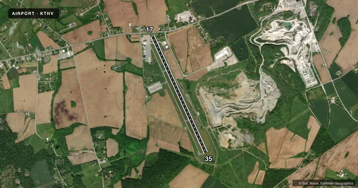
Runways & pattern
Full pagePattern entry · RWY 35
LEFT TRAFFICRunway end performance
| End | TORA | TODA | ASDA | LDA | VGSI | Approach lights | Obstruction |
|---|---|---|---|---|---|---|---|
| 17 | — | — | — | — | PAPI 4-box left(4.5°) | — | 40', pole, 226' from thr, 183' R of cntrln, slope 0 |
| 35 | — | — | — | — | PAPI 4-box left(3.67°) | — | 45', trees, 404' from thr, 223' R of cntrln, slope 4 |
Declared distances in feet. TORA = takeoff run available, TODA = takeoff distance, ASDA = accelerate-stop, LDA = landing distance.
Airport sketch
Runways drawn to scale from FAA survey coordinates, rendered over satellite imagery. Not for navigation.
Approaches & charts
Services on the field
Fuel grades, oxygen, maintenance, ramp storage and lighting — as declared to the FAA by the airport operator.
Fuel & services
- Fuel
- 100LLA
- Oxygen (bottled)
- High pressure
- Oxygen (bulk)
- Not available
- Airframe repair
- Major
- Power plant repair
- Major
Ramp & ground
- Transient storage
- Tie-down
- Hangar
- Landing fee
- Yes
- Customs
- Not available
- Lighting schedule
- SS-SR
- Beacon schedule
- SS-SR
- Beacon
- White / Green (civil land)(WG)
- Wind indicator
- Lighted
- Segmented circle
- No
Fuel & FBOs
Cheapest 100LL and Jet A on the field and nearby. Always confirm with the FBO before taxi.
Airport notes
Surface conditions, obstructions, local procedures, lighting outages and other notes published with each FAA cycle.
General notes
- TREES WI PRIM SFC 83 FT IN FM THLD & 221 FT L OF RWY 17 CNTRLN; RAMP TIE-DOWN AREA, MEDIVAC PARKING PAD & TWY WI PRIM SFC ON R SIDE.
- TWY TO RWY 35 CLSD TO ACFT WITH WINGSPAN OVER 60 FT.
- RWY 17: TREES 1383 FT OUT, 121 FT RIGHT. APCH SLP 20:1 TO DTHR.
- RWY 35: TREES 2684 FT OUT, 425 FT RIGHT. APCH SLP 22:1 TO DTHR.
- FOR CD CTC HARRISBURG APCH AT 800-932-0712.
Approach & departure obstructions
- 17RWY 17 HAS +15 FT ROAD 10-200 FT FROM RWY END 250 FT LEFT & RIGHT; +15 BLAST FENCE 50-85 FT FROM RWY END MARKED AND LIGHTED.
- 17CTLG OBSTN EXCEEDS A 45 DEG SLP.
Other notes
- LNDG FEE FOR ALL ACFT WAIVED WITH MIN FUEL PURCHASE.
VFR map & nearby airports
VFR sectional. Tap any ICAO chip to open that airport.
Key facts · KTHV
Answer card- ICAO
- KTHV
- Name
- YORK
- Location
- YORK, PENNSYLVANIA
- Elevation
- 494.7 ft MSL
- Traffic pattern altitude
- 1,494.7 ft MSL (1,000 AGL)
- Control tower
- Non-towered (use CTAF)
- Total runways
- 1
- Longest runway
- 17/35 · 5,188 ft
- Published ILS approaches
- 0
- Published frequencies
- 5
- Magnetic variation
- 11°
- Current flight rules
- VFR
- Current wind
- 320° at 6 kt
- Favored runway now
- RWY 35
York Airport is in York, Pennsylvania. The field elevation is 494.7 ft MSL. It has one runway, 17/35, which is 5,188 ft long. There is no control tower. The published pattern altitude is not listed, so use the standard 1,000 ft AGL for light piston operations unless the current Chart Supplement says otherwise.
No ILS approaches are published here. The runway is asphalt with magnetic headings of 155° and 335°. York Aviation is the on-field FBO. It carries 100LL and Jet A Prist. For clearance delivery, Harrisburg Approach handles it. Published remarks call out trees near both runway ends. Runway 17 also has a displaced-threshold approach slope and obstructions near the threshold. The taxiway to runway 35 is closed to aircraft with wingspan over 60 feet. That matters for larger aircraft planning to use the field.
This is a non-towered airport with CTAF and UNICOM on 123.0. Expect to self-announce and keep a close eye on the runway environment. The airport notes a waived landing fee for all aircraft with a minimum fuel purchase. Check the current Chart Supplement for any changes before you go.