METAR & TAF KZER
Current METAR
Observed 13:15Z
KZER 271315Z AUTO 33004KT 10SM CLR 21/17 A2992 RMK AO2
- Wind
- 330° @ 4 kt
- Visibility
- 10 SM
- Temp / Dew
- 21°C / 17°C
- Altimeter
- 29.92 inHg
- Clouds
- CLR
- Density alt
- 2,865 ft
- Ceiling
- Unlimited
- Rules
- VFR
Airport info & contacts
Manager on record, flight service, ARTCC, attendance schedule and pattern altitude — published by the FAA and refreshed every 28 days.
Location
- From city
- 8 NM W
- VFR sectional
- NEW YORK
- ARTCC
- ZNY · NEW YORK
- NOTAM facility
- IPT (NOTAM-D)
Airport manager
- Name
- BILL WILLARD
- Phone
- (570) 617-6002
- Address
- 240 AIRPORT ROAD, POTTSVILLE PA 17901
Flight service · Hours
- FSS IPT
- WILLIAMSPORT1-800-WX-BRIEF
- Attendance
- MON-FRI · 0730-1700
- SAT - SUN · ON CALL
Frequencies
Tap any row to copy the frequency to your clipboard.
Runways & pattern
Full pagePattern entry · RWY 29
LEFT TRAFFIC| Runway | Heading (°M) | Length | Surface | Traffic |
|---|---|---|---|---|
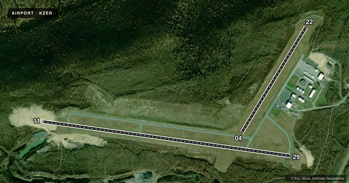
| 11/29Favored | 86° / 266° | 5,101 ft | ASPH | Standard L |
| 04/22 | 19° / 199° | 2,523 ft | TURF | Standard L |
Runway end performance
| End | TORA | TODA | ASDA | LDA | VGSI | Approach lights | Obstruction |
|---|---|---|---|---|---|---|---|
| 11 | — | — | — | — | PAPI 2-box left(3°) | — | 8', trees, 375' from thr, 480' R of cntrln, slope 21 |
| 29 | — | — | — | — | PAPI 2-box left(3°) | — | 19', trees, 221' from thr, 354' R of cntrln, slope 1 |
| 22 | — | — | — | — | — | — | 32', trees, 385' from thr, 61' R of cntrln, slope 12 |
Declared distances in feet. TORA = takeoff run available, TODA = takeoff distance, ASDA = accelerate-stop, LDA = landing distance.
Airport sketch
Runways drawn to scale from FAA survey coordinates, rendered over satellite imagery. Not for navigation.
Approaches & charts
Services on the field
Fuel grades, oxygen, maintenance, ramp storage and lighting — as declared to the FAA by the airport operator.
Fuel & services
- Fuel
- 100LLA
- Oxygen (bottled)
- Not available
- Oxygen (bulk)
- Not available
- Airframe repair
- Minor
- Power plant repair
- Minor
- Other services
- INSTR
Ramp & ground
- Transient storage
- Tie-down
- Hangar
- Landing fee
- No fee published
- Customs
- Not available
- Lighting schedule
- SEE RMK
- Beacon schedule
- SS-SR
- Beacon
- White / Green (civil land)(WG)
- Wind indicator
- Lighted
- Segmented circle
- No
Fuel & FBOs
Cheapest 100LL and Jet A on the field and nearby. Always confirm with the FBO before taxi.
Airport notes
Surface conditions, obstructions, local procedures, lighting outages and other notes published with each FAA cycle.
General notes
- DEER ON & INVOF ARPT.
- FOR CD CTC HARRISBURG APCH AT 800-932-0712.
- GPU AVAILABLE FOR AC/DC POWER.
Lighting notes
- ACTIVATE REIL RWY 11 & 29; MIRL RWY 11/29 - CTAF. PAPI RWY 11 & 29 ON CONTINUOUSLY.
Fuel notes
- 100LLAVGAS SELF SERVE WITH CREDIT CARD.
- AJET-A SELF-SERVE WITH CREDIT CARD.
Runway surface & condition
- 04/22NOT MAINTAINED WINTER MONTHS.
Approach & departure obstructions
- 04RY 04/22 EDGE & DSPLCD THLD MKD WITH ORANGE CONES.
- 22APCH RATIO 18:1 TO DTHR.
Other notes
- 1FOR SVC AFTER HRS 570-617-6002.
VFR map & nearby airports
VFR sectional. Tap any ICAO chip to open that airport.
Key facts · KZER
Answer card- ICAO
- KZER
- Name
- SCHUYLKILL COUNTY/JOE ZERBEY
- Location
- POTTSVILLE, PENNSYLVANIA
- Elevation
- 1,729.8 ft MSL
- Traffic pattern altitude
- 2,729.8 ft MSL (1,000 AGL)
- Control tower
- Non-towered (use CTAF)
- Total runways
- 2
- Longest runway
- 11/29 · 5,101 ft
- Published ILS approaches
- 0
- Published frequencies
- 4
- Magnetic variation
- 12°
- Current flight rules
- VFR
- Current wind
- 330° at 4 kt
- Favored runway now
- RWY 29
Schuylkill County/Joe Zerbey Airport sits in Pottsville, Pennsylvania. The field elevation is 1,729.8 ft MSL. It has two runways. The longest is 11/29 at 5,101 ft. Runway 04/22 is turf at 2,523 ft. There is no control tower. Traffic flows through CTAF 123.075. Pattern altitude is not published, so plan to verify the current traffic pattern in the FAA Chart Supplement before arrival. No ILS approaches are published here.
The on-field FBO is Schuylkill County Airport. It carries 100LL and Jet-A. Fuel is self-serve with credit card. The field also has ground power for AC and DC use. For after-hours service, the published number is the one to call.
A few operational items matter here. Deer are reported on and near the airport. Runway 04/22 has orange cones marking the edge and displaced threshold. That runway is not maintained during winter months. Runway 11 and 29 have REILs, medium intensity lighting and PAPI that stay on continuously. The airport is served by Harrisburg Approach for clearance delivery and approach or departure services. If you are planning a first visit, check the current Chart Supplement for any updated remarks before you go.