METAR & TAF W48
W48 does not publish a METAR.
Showing the nearest reporting station: KMTN (MARTIN STATE) · 3.9 NM away. Conditions at W48 may differ.
METAR · KMTN
Observed 21:45Z
KMTN 262145Z 16006KT 10SM OVC070 27/15 A2988
- Wind
- 160° @ 6 kt
- Visibility
- 10 SM
- Temp / Dew
- 27°C / 15°C
- Altimeter
- 29.88 inHg
- Clouds
- OVC
- Density alt
- 1,507 ft
- Ceiling
- 7,000 ft AGL
- Rules
- VFR
Airport info & contacts
Manager on record, flight service, ARTCC, attendance schedule and pattern altitude — published by the FAA and refreshed every 28 days.
Location
- From city
- 3 NM SE
- VFR sectional
- WASHINGTON
- ARTCC
- ZDC · WASHINGTON
- NOTAM facility
- DCA (NOTAM-D)
Airport manager
- Name
- JEFF AUEN
- Phone
- 443-996-1743
- Address
- 1401 DIFFENDALL ROAD, ESSEX MD 21221
Flight service · Hours
- FSS DCA
- LEESBURG1-800-WX-BRIEF
- Attendance
- Unattended
Frequencies
Tap any row to copy the frequency to your clipboard.
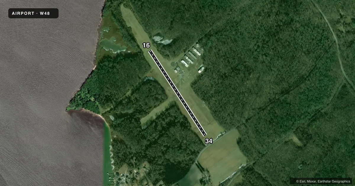
Runways & pattern
Full pagePattern entry · RWY 16
LEFT TRAFFICRunway end performance
| End | TORA | TODA | ASDA | LDA | VGSI | Approach lights | Obstruction |
|---|---|---|---|---|---|---|---|
| 16 | — | — | — | — | PAPI 2-box left(4.5°) | — | 49', trees, 1215' from thr, 0' R of cntrln, slope 20 |
| 34 | — | — | — | — | PAPI 2-box right(4.5°) | — | 58', trees, 1469' from thr, 0' R of cntrln, slope 21 |
Declared distances in feet. TORA = takeoff run available, TODA = takeoff distance, ASDA = accelerate-stop, LDA = landing distance.
Airport sketch
Runways drawn to scale from FAA survey coordinates, rendered over satellite imagery. Not for navigation.
Approaches & charts
Services on the field
Fuel grades, oxygen, maintenance, ramp storage and lighting — as declared to the FAA by the airport operator.
Fuel & services
- Fuel
- Not available
- Oxygen (bottled)
- Not available
- Oxygen (bulk)
- Not available
- Airframe repair
- Not available
- Power plant repair
- Not available
- Other services
- INSTR
Ramp & ground
- Transient storage
- Tie-down
- Landing fee
- No fee published
- Customs
- Not available
- Lighting schedule
- SEE RMK
- Beacon schedule
- SS-SR
- Beacon
- White / Green (civil land)(WG)
- Wind indicator
- Lighted
- Segmented circle
- No
Fuel & FBOs
Cheapest 100LL and Jet A on the field and nearby. Always confirm with the FBO before taxi.
Airport notes
Surface conditions, obstructions, local procedures, lighting outages and other notes published with each FAA cycle.
General notes
- TGL NA.
- FOR CD CTC POTOMAC APCH AT 866-429-5882.
Lighting notes
- ACTVT REIL RWY 16 & 34; MIRL RWY 16/34 - CTAF.
Runway surface & condition
- 16/34PLA & HEL PAT NA. PPR FOR MIL, EMERG & MED ACFT.
Other notes
- ARPT EXISTED PRIOR TO 1959; SPB AIRSPACING NO OBJECTION.
VFR map & nearby airports
VFR sectional. Tap any ICAO chip to open that airport.
Key facts · W48
Answer card- ICAO
- W48
- Name
- ESSEX SKYPARK
- Location
- BALTIMORE, MARYLAND
- Elevation
- 14 ft MSL
- Traffic pattern altitude
- 1,014 ft MSL (1,000 AGL)
- Control tower
- Non-towered (use CTAF)
- Total runways
- 1
- Longest runway
- 16/34 · 2,081 ft
- Published ILS approaches
- 0
- Published frequencies
- 2
- Magnetic variation
- 10°
- Current flight rules
- VFR
- Current wind
- 160° at 6 kt
- Favored runway now
- RWY 16
Essex Skypark sits in Baltimore, Maryland. Field elevation is 14 ft MSL. The airport has one asphalt runway, 16/34, at 2,081 ft. There is no control tower. CTAF and UNICOM are both 122.7. No ILS approaches are published here.
Pattern altitude is not published. Use the standard 1,000 ft AGL pattern for light piston aircraft unless the current FAA Chart Supplement says otherwise. The published remarks matter here. Touch-and-go landings are not authorized. Pattern and helicopter pattern are not authorized. Prior permission is required for military, emergency and medical aircraft. Runway 16 and 34 have medium intensity runway lights. The runway ends also have identifier lights. That helps at night.
There are no on-field FBOs listed in the facts. Contact the airport operator directly before arrival. You can also call the field on CTAF or UNICOM for current FBO availability. For clearance delivery, Potomac Approach is listed at 866-429-5882. Pilots should also verify current airspace and any local procedures before flying in. The field is close to the Baltimore metro area. Expect a busy environment and plan ahead for arrival and departure spacing.