METAR & TAF W42
W42 does not publish a METAR.
Showing the nearest reporting station: KMTN (MARTIN STATE) · 10.5 NM away. Conditions at W42 may differ.
METAR · KMTN
Observed 11:47Z
KMTN 271147Z 00000KT 10SM SCT022 BKN100 24/19 A2987
- Wind
- 000° @ 0 kt
- Visibility
- 10 SM
- Temp / Dew
- 24°C / 19°C
- Altimeter
- 29.87 inHg
- Clouds
- BKN
- Density alt
- 1,712 ft
- Ceiling
- 10,000 ft AGL
- Rules
- VFR
Airport info & contacts
Manager on record, flight service, ARTCC, attendance schedule and pattern altitude — published by the FAA and refreshed every 28 days.
Location
- From city
- 1 NM S
- VFR sectional
- WASHINGTON
- ARTCC
- ZDC · WASHINGTON
- NOTAM facility
- DCA (NOTAM-D)
Airport manager
- Name
- SHARON MILLS AND MICHAEL MILLS
- Phone
- 410-877-9889
- Address
- 711 RECKORD RD, FALLSTON MD 21047
Flight service · Hours
- FSS DCA
- LEESBURG1-800-WX-BRIEF
- Attendance
- Unattended
Frequencies
Tap any row to copy the frequency to your clipboard.
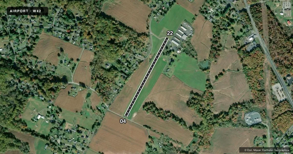
Runways & pattern
Full pagePattern entry · RWY 04
LEFT TRAFFICRunway end performance
| End | TORA | TODA | ASDA | LDA | VGSI | Approach lights | Obstruction |
|---|---|---|---|---|---|---|---|
| 04 | — | — | — | — | — | — | 81', trees, 1200' from thr, 169' R of cntrln, slope 12 |
| 22 | — | — | — | — | — | — | 67', trees, 1390' from thr, 97' R of cntrln, slope 17 |
Declared distances in feet. TORA = takeoff run available, TODA = takeoff distance, ASDA = accelerate-stop, LDA = landing distance.
Airport sketch
Runways drawn to scale from FAA survey coordinates, rendered over satellite imagery. Not for navigation.
Approaches & charts
Services on the field
Fuel grades, oxygen, maintenance, ramp storage and lighting — as declared to the FAA by the airport operator.
Fuel & services
- Fuel
- 100LL
- Oxygen (bottled)
- Not available
- Oxygen (bulk)
- Not available
- Airframe repair
- Not available
- Power plant repair
- Not available
Ramp & ground
- Transient storage
- Tie-down
- Landing fee
- No fee published
- Customs
- Not available
- Lighting schedule
- SEE RMK
- Wind indicator
- Yes
- Segmented circle
- No
Fuel & FBOs
Cheapest 100LL and Jet A on the field and nearby. Always confirm with the FBO before taxi.
Airport notes
Surface conditions, obstructions, local procedures, lighting outages and other notes published with each FAA cycle.
General notes
- ARPT CLSD DUSK-0900 DAILY.
- DEER & WILDLIFE ON & INVOF ARPT.
- FOR CD CTC POTOMAC APCH AT 866-429-5882.
Lighting notes
- NSTD LIRL AVAILABLE TO BASED AIRCRAFT W/PRIOR NOTICE. FOR NSTD LIRL RY 04/22 CTC AMGR 410-877-9889.
Fuel notes
- 100LLIF NO ONE PPRESENT DURING DAYLIGHT HOURS CALL 410-877-9889.
Runway surface & condition
- 04/22RY 04/22 NSTD LIRL; TWO THLD LGTS EACH SIDE & 300 FT EDGE LGT SPACING.
Approach & departure obstructions
- 04RY 04 HAS +10 FT ROAD 45 FT FM THLD.
- 22+15 FT ACCESS ROAD AT THLD; +25 FT BLDG, 137 FT L OF APCH NMRS.
- 04APCH SLP 20:1 TO 315 FT DSP THD AT CNTRLN.
- 22APCH SLP 20:1 TO 220 FT DSP THD AT CNTRLN.
Other notes
- EXISTED PRIOR TO 1959.
- 1IF ATTENDENT NOT PRESENT DURG DALGT HOURS CALL 410-877-9889.
- OWNERFULL OWNER NAME: FALLSTON AIRPORT & FLYING SERVICE, INC.
- MANAGERALTERNATE EMERGENCY PHONE (410) 808-3289
VFR map & nearby airports
VFR sectional. Tap any ICAO chip to open that airport.
Key facts · W42
Answer card- ICAO
- W42
- Name
- FALLSTON
- Location
- FALLSTON, MARYLAND
- Elevation
- 460 ft MSL
- Traffic pattern altitude
- 1,460 ft MSL (1,000 AGL)
- Control tower
- Non-towered (use CTAF)
- Total runways
- 1
- Longest runway
- 04/22 · 2,200 ft
- Published ILS approaches
- 0
- Published frequencies
- 1
- Magnetic variation
- 10°
- Current flight rules
- VFR
- Current wind
- 000° at 0 kt
- Favored runway now
- –
Fallston Airport sits in Fallston, Maryland. Field elevation is 460 ft MSL. The airport has one runway. Runway 04/22 is 2,200 ft long and asphalt. There is no control tower. CTAF is 122.9. No ILS approaches are published here.
Pattern altitude is not published. Use the standard 1,000 ft AGL pattern unless the current Chart Supplement or the airport operator gives you a different instruction. The field has nonstandard low intensity runway lights on 04/22. Based aircraft can use them with prior notice. Call the airport manager at 410-877-9889 if you need them. Deer and wildlife are reported on and near the airport, so keep a sharp scan on departure and arrival. There are also published obstructions near both runway ends. Runway 04 has a road close to the threshold. Runway 22 has an access road at the threshold area plus a building left of the approach path.
Fallston Airport & Flying Service is on the field. It carries AVGAS 100LL. If the attendant is not present during daylight hours, call 410-877-9889. For clearance delivery, contact Potomac Approach at 866-429-5882. This is a small, uncontrolled field with a short runway, so plan your performance carefully and verify current conditions before you go.