METAR & TAF KMTN
Current METAR
Observed 19:48Z
KMTN 231948Z 01005KT 10SM BKN014 OVC023 20/18 A2993
- Wind
- 010° @ 5 kt
- Visibility
- 10 SM
- Temp / Dew
- 20°C / 18°C
- Altimeter
- 29.93 inHg
- Clouds
- OVC
- Density alt
- 615 ft
- Ceiling
- 1,400 ft AGL
- Rules
- MVFR
Airport info & contacts
Manager on record, flight service, ARTCC, attendance schedule and pattern altitude — published by the FAA and refreshed every 28 days.
Location
- From city
- 9 NM E
- VFR sectional
- WASHINGTON
- ARTCC
- ZDC · WASHINGTON
- NOTAM facility
- MTN (NOTAM-D)
Airport manager
- Name
- HAROLD A. FOWLER
- Phone
- 410-682-8800
- Address
- BOX 1, 701 WILSON POINT RD, BALTIMORE MD 21220
Flight service · Hours
- FSS DCA
- LEESBURG1-800-WX-BRIEF
- Attendance
- 0600-2100
Frequencies
Tap any row to copy the frequency to your clipboard.
Runways & pattern
Full pagePattern entry · RWY 33
LEFT TRAFFICRunway end performance
| End | TORA | TODA | ASDA | LDA | VGSI | Approach lights | Obstruction |
|---|---|---|---|---|---|---|---|
| 15 | — | — | — | — | PSIL(4.01°) | — | 86', trees, 2142' from thr, 301' R of cntrln, slope 22 |
| 33 | — | — | — | — | PSIL(2.91°) | — | 64', trees, 3282' from thr, 57' R of cntrln, slope 48 |
Declared distances in feet. TORA = takeoff run available, TODA = takeoff distance, ASDA = accelerate-stop, LDA = landing distance.
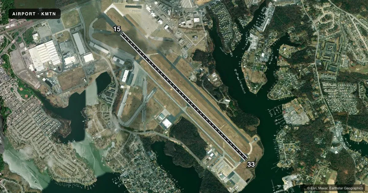
Airport sketch
Runways drawn to scale from FAA survey coordinates, rendered over satellite imagery. Not for navigation.
Approaches & charts
ILS · 2
Services on the field
Fuel grades, oxygen, maintenance, ramp storage and lighting — as declared to the FAA by the airport operator.
Fuel & services
- Fuel
- 100LLA+
- Oxygen (bottled)
- Not available
- Oxygen (bulk)
- Not available
- Airframe repair
- Minor
- Power plant repair
- Minor
- Other services
- AMB,AVNCS,CHTR,INSTR,RNTL
Ramp & ground
- Transient storage
- Tie-down
- Hangar
- Landing fee
- No fee published
- Customs
- Not available
- Lighting schedule
- SEE RMK
- Beacon schedule
- SS-SR
- Beacon
- White / Green (civil land)(WG)
- Wind indicator
- Lighted
- Segmented circle
- No
Fuel & FBOs
Cheapest 100LL and Jet A on the field and nearby. Always confirm with the FBO before taxi.
Airport notes
Surface conditions, obstructions, local procedures, lighting outages and other notes published with each FAA cycle.
General notes
- NOISE ABATEMENT PROCS IN EFCT. WHEN ATCT CLSD NO PRACTICE LNDGS OR APCHS.
- SEAGULLS ON & INVOF ARPT.
- ARPT CONDS UNMON 2300-0600.
- MOWING OPS CONDUCTED DURG DALGT.
- PPR FOR PRACTICE TKOFS & LNDGS FOR ACFT WEIGHING MORE THAN 12500 LBS.
- RECREATIONAL SAILBOAT MASTS TO +50 FT & MOTOR BOATS IN WATERWAY AT AER 33 813 FT FM THR ON CNTRLN.
- FOR ADDL INFO CTC AMGR 410-682-8800.
- BEARING STRENGTH RWY 15/33: ST175.
- MILITARY: CAUTION: BASH II IN EFFECT AUG-JAN.
- MILITARY: ANG: CALL COMD POST/RAVEN OPS 275.500 OR 139.900 10 MIN PRIOR TO LNDG. NO SPACE A, FLEET SVC, OR TRAN QTRS AVBL. PPR AFTER DUTY HR RQR OG/CC APVL. C-5/C-17 ACFT RSTRD TO TWY A. PPR FOR SVC AND USE OF ANG PRK RAMP ONLY, DSN 243-6630/6637/6444, C410-918-6630/6637/6444; AFTER DUTY HR CTC C443-421-3128.
- FOR CD WHEN TWR CLSD CTC POTOMAC APCH AT 866-429-5882.
- ARFF SVCS AVBL 24 HRS DAILY. FOR ARFF SVCS WHEN ATCT CLSD CTC ARFF STATION; CTAF OR 410-918-6257 / 410-918-6911.
- NO ACFT ACCESS TO TWY S FM STRAWBERRY POINT RAMP.
- MILITARY: MISC: LTD RESOURCES AVBL FOR TRAN MIL ACFT.
Lighting notes
- DUSK-DAWN. WHEN ATCT CLSD ACTVT REIL RWYS 15 & 33; HIRL RWY 15/33 - CTAF. WHEN ATCT CLSD ACTVT TWY F LGTS - UNICOM.
Fuel notes
- 100LL24 HR SELF SERVE 100LL AVBL WITH CREDIT CARD. HELIS NOT AUTH TO ACES THE 100-LL SELF SVC STN UNDER OWN PWR.
Runway surface & condition
- 15/338100 FT AVBL FOR TKOF RWY 15 AND LNDG RWY 33 FOR MIL ACFT ONLY.
Approach & departure obstructions
- 15UNUSBL BYD 5 DEGS EITHER SIDE OF CNTRLN.
- 15BOAT MAST
Other notes
- TPA RECIPROCATING ENG ACFT 978 FT AGL; TURBOPROP & CIVIL JET ACFT 1478 FT AGL; MIL JET ACFT 1978 FT AGL.
- OWNERMARYLAND AVN ADMIN.
VFR map & nearby airports
VFR sectional. Tap any ICAO chip to open that airport.
Key facts · KMTN
Answer card- ICAO
- KMTN
- Name
- MARTIN STATE
- Location
- BALTIMORE, MARYLAND
- Elevation
- 22.2 ft MSL
- Traffic pattern altitude
- 1,022.2 ft MSL (1,000 AGL)
- Control tower
- Towered · 0600-2200
- Total runways
- 1
- Longest runway
- 15/33 · 6,999 ft
- Published ILS approaches
- 2
- Published frequencies
- 13
- Magnetic variation
- 11°
- Current flight rules
- MVFR
- Current wind
- 010° at 5 kt
- Favored runway now
- RWY 33
Martin State Airport is in Baltimore, Maryland. The field elevation is 22.2 ft MSL. It has one runway, 15/33, which is 6,999 ft long and paved. The airport is towered from 0600 to 2200. Two ILS approaches are published, one for runway 15 and one for runway 33.
Traffic pattern altitude is not published in the usual way for this field. Use 978 ft AGL for reciprocating engine aircraft. Use 1,478 ft AGL for turboprop and civil jet aircraft. Use 1,978 ft AGL for military jet aircraft. The airport sits in the Baltimore area, so expect busy local traffic and follow the published noise abatement procedures. When the tower is closed, no practice landings or approaches are permitted.
Martin State Airport is the on-field FBO. It carries 100LL and Jet A Prist. Twenty-four hour self-serve 100LL is available with credit card. The airport also has runway lighting available from dusk to dawn. When the tower is closed, use CTAF for runway end identifier lights and high intensity runway lights on 15/33. Use UNICOM for taxiway F lights. One operational note for runway 15: the visual glide slope indicators are unusable beyond 5 degrees either side of centerline. Seagulls are also present on and near the airport.