METAR & TAF 06N
06N does not publish a METAR.
Showing the nearest reporting station: KMGJ (ORANGE COUNTY) · 7.5 NM away. Conditions at 06N may differ.
METAR · KMGJ
Observed 12:54Z
KMGJ 271254Z AUTO 00000KT 10SM CLR 22/18 A2984 RMK AO2 SLP101 T02170178
- Wind
- 000° @ 0 kt
- Visibility
- 10 SM
- Temp / Dew
- 22°C / 18°C
- Altimeter
- 29.84 inHg
- Clouds
- CLR
- Density alt
- 1,587 ft
- Ceiling
- Unlimited
- Rules
- VFR
Airport info & contacts
Manager on record, flight service, ARTCC, attendance schedule and pattern altitude — published by the FAA and refreshed every 28 days.
Location
- From city
- 2 NM SE
- VFR sectional
- NEW YORK
- ARTCC
- ZNY · NEW YORK
- NOTAM facility
- ISP (NOTAM-D)
Airport manager
- Name
- CHARLES BRODIE
- Phone
- 845-343-5965
- Address
- P O BOX 3062, 100 AIRPORT RD, MIDDLETOWN NY 10940
Flight service · Hours
- FSS ISP
- NEW YORK1-800-WX-BRIEF
- Attendance
- Unattended
Frequencies
Tap any row to copy the frequency to your clipboard.
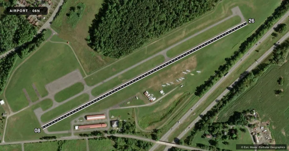
Runways & pattern
Full pagePattern entry · RWY 08
LEFT TRAFFICRunway end performance
| End | TORA | TODA | ASDA | LDA | VGSI | Approach lights | Obstruction |
|---|---|---|---|---|---|---|---|
| 08 | — | — | — | — | PAPI 2-box left(4°) | — | 16', road, 200' from thr, 72' R of cntrln, slope 0 |
| 26 | — | — | — | — | PAPI 2-box right(4°) | — | 25', trees, 295' from thr, 110' R of cntrln, slope 3 |
Declared distances in feet. TORA = takeoff run available, TODA = takeoff distance, ASDA = accelerate-stop, LDA = landing distance.
Airport sketch
Runways drawn to scale from FAA survey coordinates, rendered over satellite imagery. Not for navigation.
Approaches & charts
Services on the field
Fuel grades, oxygen, maintenance, ramp storage and lighting — as declared to the FAA by the airport operator.
Fuel & services
- Fuel
- Not available
- Oxygen (bottled)
- Not available
- Oxygen (bulk)
- Not available
- Airframe repair
- Not available
- Power plant repair
- Not available
- Other services
- GLD,TOW
Ramp & ground
- Transient storage
- Tie-down
- Landing fee
- No fee published
- Customs
- Not available
- Lighting schedule
- SEE RMK
- Wind indicator
- Yes
- Segmented circle
- No
Fuel & FBOs
Cheapest 100LL and Jet A on the field and nearby. Always confirm with the FBO before taxi.
Airport notes
Surface conditions, obstructions, local procedures, lighting outages and other notes published with each FAA cycle.
General notes
- HVY GLIDER & HANG GLIDER ACT ON WKENDS & HOLS.
- ULTRA-LIGHT ON AND INVOF ARPT.
- FOR CD CTC NEW YORK APCH AT 516-683-2448.
Lighting notes
- ACTVT PAPI RWY 08; MIRL RWY 08/26 - CTAF.
Runway surface & condition
- 08/26SEVERAL RWY AND TWY LGTS OTS INDEFLY.
Approach & departure obstructions
- 08+16FT ROAD, 0-200FT FRM RWY, 72FT RIGHT; +25FT TO +40FT TREES, 0-75FT FRM RWY, 120-140FT RT; +4FT FENCE, 0-200FT FRM RWY, 50 FT RT.
- 26RISING TERRAIN, +0FT TO +17FT HIGH, 0-200FT FRM RWY, 0-250FT RT; +25 FT TREES, 0-200FT FRM RWY, 175-200 FT LT.
- 08RUNWAY MARKINGS VERY BADLY FADED.
- 26OTS INDEFLY.
- 08RWY 08 APCH SLOPE 16:1 DUE TO 65 FT TREE 1040 FT FM DTHR.
Other notes
- NON COMPLIANCE WITH FAR 157.
- 08/26SW STRENGTH IS 12.5.
VFR map & nearby airports
VFR sectional. Tap any ICAO chip to open that airport.
Key facts · 06N
Answer card- ICAO
- 06N
- Name
- RANDALL
- Location
- MIDDLETOWN, NEW YORK
- Elevation
- 522.7 ft MSL
- Traffic pattern altitude
- 1,522.7 ft MSL (1,000 AGL)
- Control tower
- Non-towered (use CTAF)
- Total runways
- 1
- Longest runway
- 08/26 · 2,810 ft
- Published ILS approaches
- 0
- Published frequencies
- 4
- Magnetic variation
- 13°
- Current flight rules
- VFR
- Current wind
- 000° at 0 kt
- Favored runway now
- –
Randall Airport is in Middletown, New York. The field elevation is 522.7 ft MSL. It has one runway, 08/26, which is 2,810 ft long and asphalt. There is no control tower. Pattern altitude is not published, so a light piston pilot would normally plan on 1,000 ft AGL unless the current Chart Supplement says otherwise.
No ILS approaches are published here. The airport uses CTAF 122.8 and UNICOM 122.8. For clearance delivery, contact New York Approach on 516-683-2448. The published remarks also note that runway lighting on 08 and 26 is activated by CTAF. Several runway and taxiway lights are out of service indefinitely. Runway 26 also has a VASI out of service indefinitely. Runway 08 has faded markings. It also has close-in obstacles and a steep approach profile because of a tree on final.
There are no on-field FBOs listed in the facts. Check with the airport operator or the FBO directly by phone before you go. First-time visitors should pay close attention to the runway environment. The field has ultralight activity. Heavy glider and hang glider traffic shows up on weekends and holidays. The runway surface strength is published as 12.5. Use the current Chart Supplement for any noise or operating restrictions before flying in.