METAR & TAF N89
N89 does not publish a METAR.
Showing the nearest reporting station: KMGJ (ORANGE COUNTY) · 14.0 NM away. Conditions at N89 may differ.
METAR · KMGJ
Observed 12:54Z
KMGJ 271254Z AUTO 00000KT 10SM CLR 22/18 A2984 RMK AO2 SLP101 T02170178
- Wind
- 000° @ 0 kt
- Visibility
- 10 SM
- Temp / Dew
- 22°C / 18°C
- Altimeter
- 29.84 inHg
- Clouds
- CLR
- Density alt
- 1,299 ft
- Ceiling
- Unlimited
- Rules
- VFR
Airport info & contacts
Manager on record, flight service, ARTCC, attendance schedule and pattern altitude — published by the FAA and refreshed every 28 days.
Location
- From city
- 1 NM NE
- VFR sectional
- NEW YORK
- ARTCC
- ZNY · NEW YORK
- NOTAM facility
- ISP (NOTAM-D)
Airport manager
- Name
- TERRY HOUCK
- Phone
- 845-647-7800
- Address
- TOWN SUPERVISOR, 108 CANAL STREET, ELLENVILLE NY 12428
Flight service · Hours
- FSS ISP
- NEW YORK1-800-WX-BRIEF
- Attendance
- 0800-DARK
Frequencies
Tap any row to copy the frequency to your clipboard.
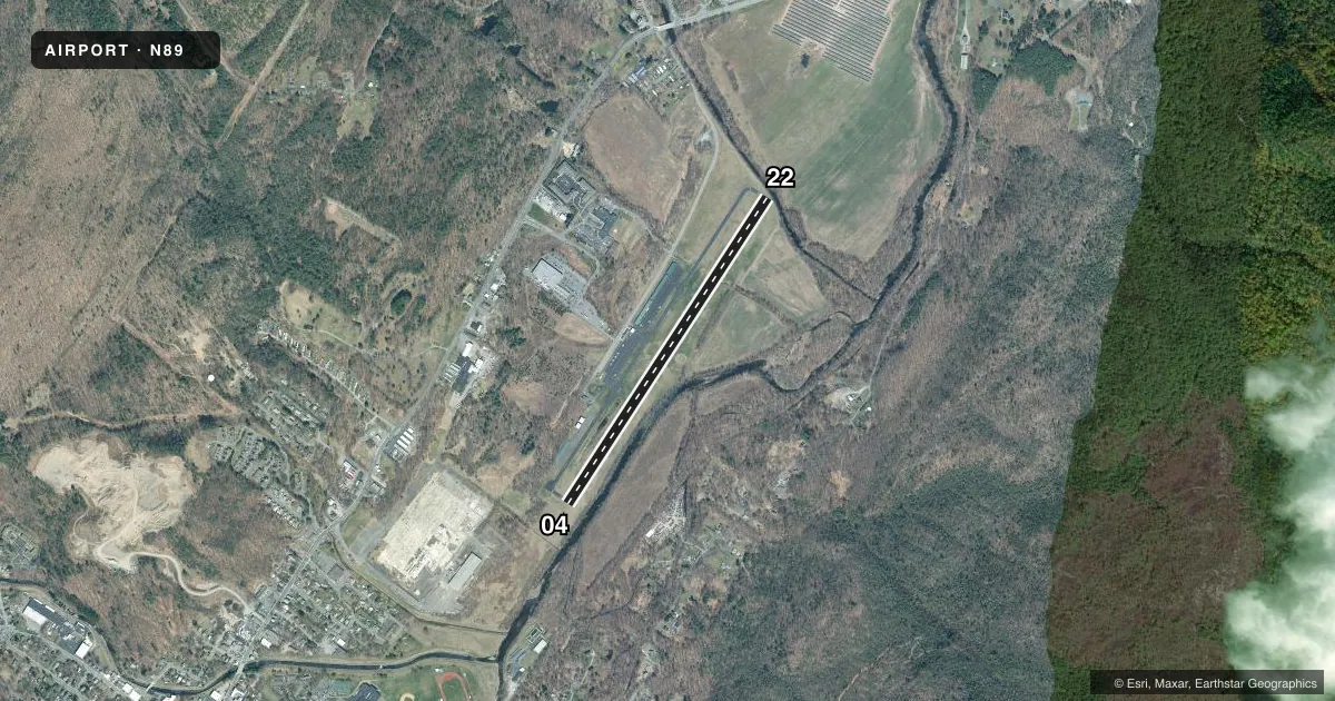
Runways & pattern
Full pagePattern entry · RWY 04
LEFT TRAFFICRunway end performance
| End | TORA | TODA | ASDA | LDA | VGSI | Approach lights | Obstruction |
|---|---|---|---|---|---|---|---|
| 04 | 3,838' | 3,838' | 3,838' | 3,538' | PAPI 2-box left(3.5°) | — | 109', trees, 336' from thr, 236' R of cntrln, slope 1 |
| 22 | 3,838' | 3,838' | 3,838' | 3,538' | PAPI 2-box left(3°) | — | — |
Declared distances in feet. TORA = takeoff run available, TODA = takeoff distance, ASDA = accelerate-stop, LDA = landing distance.
Airport sketch
Runways drawn to scale from FAA survey coordinates, rendered over satellite imagery. Not for navigation.
Approaches & charts
Services on the field
Fuel grades, oxygen, maintenance, ramp storage and lighting — as declared to the FAA by the airport operator.
Fuel & services
- Fuel
- 100LL
- Oxygen (bottled)
- Not available
- Oxygen (bulk)
- Not available
- Airframe repair
- Minor
- Power plant repair
- Minor
- Other services
- INSTR
Ramp & ground
- Transient storage
- Tie-down
- Hangar
- Landing fee
- No fee published
- Lighting schedule
- SEE RMK
- Beacon schedule
- SS-SR
- Beacon
- White / Green (civil land)(WG)
- Wind indicator
- Lighted
- Segmented circle
- Yes
Fuel & FBOs
Cheapest 100LL and Jet A on the field and nearby. Always confirm with the FBO before taxi.
Airport notes
Surface conditions, obstructions, local procedures, lighting outages and other notes published with each FAA cycle.
General notes
- AVOID OVERFLIGHT OF SCHOOL & VILLAGE WHEN TAKING OFF RWY 22 OR APCH TO RWY 4, HEL OPNS FOLLOW FIXED WING FLT PAT.
- AVOID OVERFLIGHT OF HOSP & SCHOOL BUILDINGS APPROX 1 MILE SW OF RWY 22 & PRISON APPROX 1/2 MILE NE OF ARPT.
- RWY 04; 60 FT TREES 200 FT FM RWY, 191 RIGHT.
- RWY 22; 8 FT FENCE CROSSES RWY 24 FT FM THR.
- AWOS FREQUENCY 122.8 - 5 CLICKS.
- FOR CD CTC NEW YORK APCH AT 516-683-2448
- COLD TEMPERATURE AIRPORT. ALTITUDE CORRECTION REQUIRED AT OR BELOW -5C.
Lighting notes
- ACTVT REIL RWY 04 & 22; PAPI RWY 04 & 22; MIRL RWY 04/22 - CTAF.
Approach & departure obstructions
- 04RWY 04 65 FT TREES, 0 FT FM RWY THLD, 206 FT RIGHT.
- 22RY 22 +35-55 FT TREES, 0-80 FT FROM RY THRESHOLD, 90-200 FT LEFT OF CNTRLN; -6 FT CREEK 0B 50 FT FROM THRESHOLD; +8 FT FENCE CROSSES RUNWAY 24 FT FROM THRESHOLD.
- 22RWY 22 APCH RATIO 0:1 TO DTHR BASED ON 8 FT FENCE 243 FT LEFT OF DTHR. RWY 22 CLNC OBSTN IS CORN IN FIELD.
Other notes
- VFR USE ONLY
VFR map & nearby airports
VFR sectional. Tap any ICAO chip to open that airport.
Key facts · N89
Answer card- ICAO
- N89
- Name
- JOSEPH Y RESNICK
- Location
- ELLENVILLE, NEW YORK
- Elevation
- 290.2 ft MSL
- Traffic pattern altitude
- 1,290.2 ft MSL (1,000 AGL)
- Control tower
- Non-towered (use CTAF)
- Total runways
- 1
- Longest runway
- 04/22 · 3,839 ft
- Published ILS approaches
- 0
- Published frequencies
- 4
- Magnetic variation
- 14°
- Current flight rules
- VFR
- Current wind
- 000° at 0 kt
- Favored runway now
- –
Joseph Y Resnick Airport (N89) sits in Ellenville, New York. Field elevation is 290.2 ft MSL. The airport has one runway. Runway 04/22 is 3,839 ft long and asphalt. There is no control tower. Use CTAF 122.8. AWOS is also on 122.8 with 5 clicks. No ILS approaches are published, so plan for VFR only. The published pattern altitude is not listed. Use the standard 1,000 ft AGL pattern for light piston traffic unless the current Chart Supplement says otherwise.
The on-field FBO is Joseph Y. Resnick Airport. It carries AVGAS 100LL. Call (845) 647-6570 for current service details before you go. Published remarks matter here. Runway 04 has trees close to the threshold. Runway 22 also has several close-in obstructions, including trees, a creek and a fence near the threshold. There are also overflight cautions for the hospital, school buildings, prison, school and village. Helicopter traffic follows the fixed-wing pattern. This is a cold temperature airport. Altitude correction is required at or below minus 5 degrees Celsius. For clearance delivery, contact New York Approach at 516-683-2448. If you are planning a first visit, brief the runway environment carefully. Expect a tight pattern with nearby obstacles.