METAR & TAF KMSV
Current METAR
Observed 12:56Z
KMSV 271256Z AUTO 33003KT 10SM CLR 22/17 A2989 RMK AO2 SLP113 T02220172 PNO $
- Wind
- 330° @ 3 kt
- Visibility
- 10 SM
- Temp / Dew
- 22°C / 17°C
- Altimeter
- 29.89 inHg
- Clouds
- CLR
- Density alt
- 2,617 ft
- Ceiling
- Unlimited
- Rules
- VFR
Airport info & contacts
Manager on record, flight service, ARTCC, attendance schedule and pattern altitude — published by the FAA and refreshed every 28 days.
Location
- From city
- 6 NM NW
- VFR sectional
- NEW YORK
- ARTCC
- ZNY · NEW YORK
- NOTAM facility
- MSV (NOTAM-D)
Airport manager
- Name
- RYAN BROWN
- Phone
- 845-807-0326
- Address
- 100 NORTH ST, MONTICELLO NY 12701
Flight service · Hours
- FSS ISP
- NEW YORK1-800-WX-BRIEF
- Attendance
- 0630-1700
Frequencies
Tap any row to copy the frequency to your clipboard.
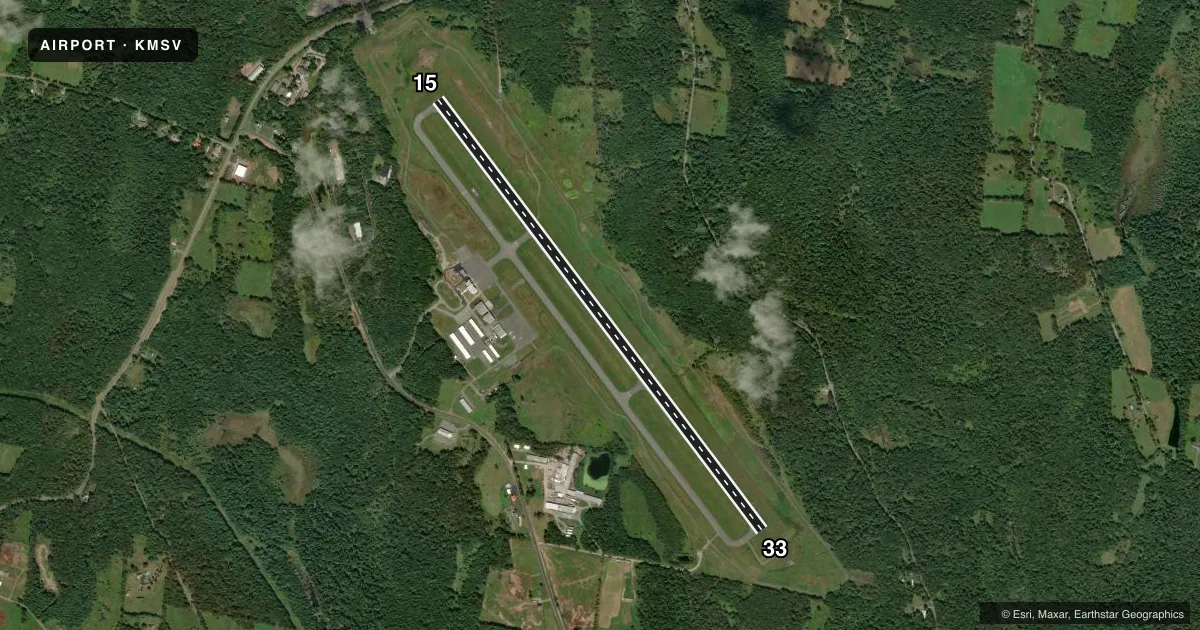
Runways & pattern
Full pagePattern entry · RWY 33
LEFT TRAFFICRunway end performance
| End | TORA | TODA | ASDA | LDA | VGSI | Approach lights | Obstruction |
|---|---|---|---|---|---|---|---|
| 15 | 6,298' | 6,298' | 6,198' | 5,900' | PAPI 4-box left(3°) | — | 62', trees, 2050' from thr, 750' R of cntrln, slope 29 |
| 33 | 6,298' | 6,298' | 6,098' | 5,798' | PAPI 4-box left(3°) | — | 19', trees, 520' from thr, 500' R of cntrln, slope 16 |
Declared distances in feet. TORA = takeoff run available, TODA = takeoff distance, ASDA = accelerate-stop, LDA = landing distance.
Airport sketch
Runways drawn to scale from FAA survey coordinates, rendered over satellite imagery. Not for navigation.
Approaches & charts
ILS · 1
Services on the field
Fuel grades, oxygen, maintenance, ramp storage and lighting — as declared to the FAA by the airport operator.
Fuel & services
- Fuel
- 100LLA
- Oxygen (bottled)
- Not available
- Oxygen (bulk)
- Not available
- Airframe repair
- Major
- Power plant repair
- Minor
- Other services
- AMB,CHTR
Ramp & ground
- Transient storage
- Tie-down
- Hangar
- Landing fee
- Yes
- Customs
- Not available
- Lighting schedule
- SEE RMK
- Beacon schedule
- SS-SR
- Beacon
- White / Green (civil land)(WG)
- Wind indicator
- Lighted
- Segmented circle
- No
Fuel & FBOs
Cheapest 100LL and Jet A on the field and nearby. Always confirm with the FBO before taxi.
Airport notes
Surface conditions, obstructions, local procedures, lighting outages and other notes published with each FAA cycle.
General notes
- BIRDS/WATERFOWL, COYOTE & DEER ON & INVOF ARPT.
- FOR CD CTC NEW YORK APCH AT 516-683-2448 OR 121.6
Lighting notes
- ACTVT REIL RWY 15 & 33; HIRL RWY 15/33; TWY LGTS - CTAF. PAPI RWY 15 & 33 OPR CONSLY.
Fuel notes
- 100LLSELF SVC 100LL FUEL AVBL 24 HRS DLY.
- AJET A FUEL AVBL; 0800-1700 CALL 845-807-0325. AFTR HRS ADVN NOTICE REQ.
Runway surface & condition
- 15/33PCR VALUE: 596/F/C/X/T
Approach & departure obstructions
- 158 FT GROUND AER 320 FT LEFT.
Other notes
- PPR 24 HRS FOR ACR OPS WITH MORE THAN 30 PAX SEATS; CALL AMGR 845-807-0325 OR 845-665-1714.
- LANDING FEE FOR ACFT OVER 8000 LBS & ALL COML ACFT REGARDLESS OF WEIGHT.
VFR map & nearby airports
VFR sectional. Tap any ICAO chip to open that airport.
Key facts · KMSV
Answer card- ICAO
- KMSV
- Name
- SULLIVAN COUNTY INTL
- Location
- MONTICELLO, NEW YORK
- Elevation
- 1,403 ft MSL
- Traffic pattern altitude
- 2,403 ft MSL (1,000 AGL)
- Control tower
- Non-towered (use CTAF)
- Total runways
- 1
- Longest runway
- 15/33 · 6,298 ft
- Published ILS approaches
- 1
- Published frequencies
- 5
- Magnetic variation
- 12°
- Current flight rules
- VFR
- Current wind
- 330° at 3 kt
- Favored runway now
- RWY 33
Sullivan County Intl sits in Monticello, New York. Field elevation is 1,403 ft MSL. The airport has one runway. Runway 15/33 is 6,298 ft long with asphalt pavement. There is no control tower. Pattern altitude is not published. Use 1,000 ft AGL for light piston traffic unless the current Chart Supplement says otherwise. The field has one ILS approach. It serves runway 15. Runway 15 and 33 have REIL, high intensity lighting and PAPI that operate continuously. Taxiway lights are controlled by CTAF.
The on-field FBO is Sullivan County International Airport. It carries 100LL and Jet A. Self-serve 100LL is available 24 hours daily. Jet A is available from 0800 to 1700. Call ahead for after-hours Jet A. Clearance delivery is handled through New York Approach on 121.6 or by phone if needed. The field also has a landing fee for aircraft over 8,000 pounds and all commercial aircraft. Expect wildlife on and near the airport. Birds, waterfowl, coyotes and deer are reported in the area. There is also an 8-foot ground obstruction 320 feet left of runway 15. For a first-time arrival, the main things to plan for are the elevation, the wildlife and the published obstruction near 15.