METAR & TAF 44N
44N does not publish a METAR.
Showing the nearest reporting station: KPOU (HUDSON VALLEY RGNL) · 8.2 NM away. Conditions at 44N may differ.
METAR · KPOU
Observed 12:53Z
KPOU 271253Z AUTO 00000KT 10SM CLR 23/18 A2983 RMK AO2 SLP097 T02280178
- Wind
- 000° @ 0 kt
- Visibility
- 10 SM
- Temp / Dew
- 23°C / 18°C
- Altimeter
- 29.83 inHg
- Clouds
- CLR
- Density alt
- 1,936 ft
- Ceiling
- Unlimited
- Rules
- VFR
Airport info & contacts
Manager on record, flight service, ARTCC, attendance schedule and pattern altitude — published by the FAA and refreshed every 28 days.
Location
- From city
- 6 NM SW
- VFR sectional
- NEW YORK
- ARTCC
- ZNY · NEW YORK
- NOTAM facility
- ISP (NOTAM-D)
Airport manager
- Name
- STEVEN STYLES
- Phone
- 845-677-5010
- Address
- 30 AIRWAY DRIVE, LAGRANGEVILLE NY 12540
Flight service · Hours
- FSS ISP
- NEW YORK1-800-WX-BRIEF
- Attendance
- MON-FRI · 0800-1600
- SAT-SUN · 0800-1600
Frequencies
Tap any row to copy the frequency to your clipboard.
Runways & pattern
Full pagePattern entry · RWY 17
LEFT TRAFFICRunway end performance
| End | TORA | TODA | ASDA | LDA | VGSI | Approach lights | Obstruction |
|---|---|---|---|---|---|---|---|
| 17 | — | — | — | — | — | — | 19', trees, 336' from thr, 256' R of cntrln, slope 7 |
| 35 | — | — | — | — | PAPI 2-box left(3°) | — | 49', trees, 713' from thr, 88' R of cntrln, slope 10 |
Declared distances in feet. TORA = takeoff run available, TODA = takeoff distance, ASDA = accelerate-stop, LDA = landing distance.
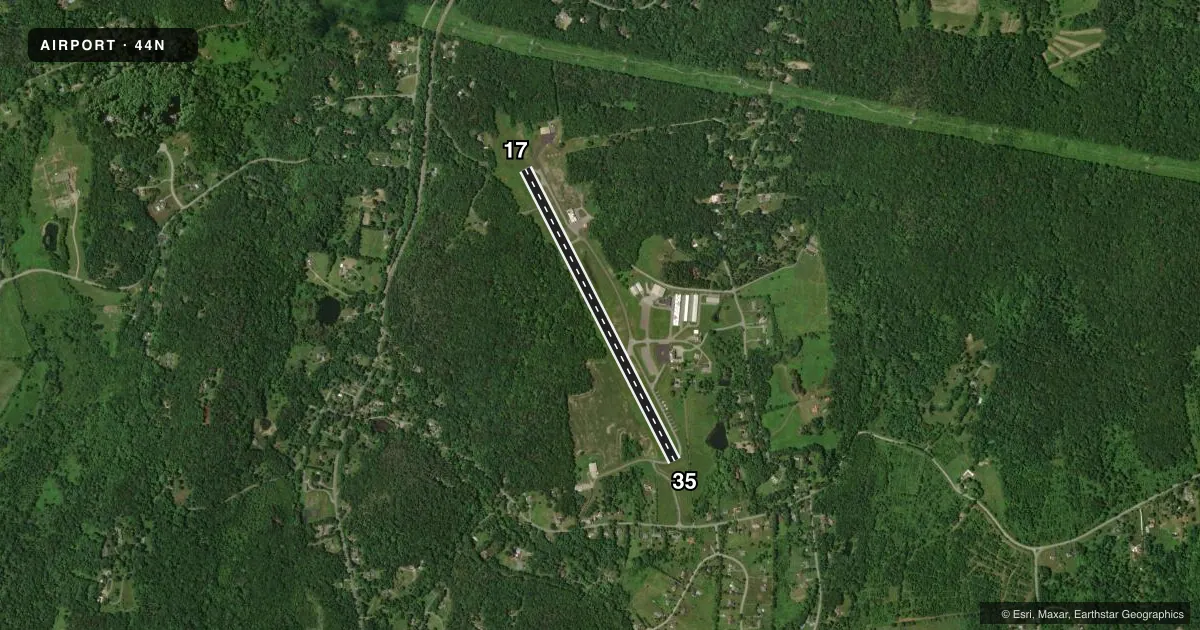
Airport sketch
Runways drawn to scale from FAA survey coordinates, rendered over satellite imagery. Not for navigation.
Approaches & charts
Services on the field
Fuel grades, oxygen, maintenance, ramp storage and lighting — as declared to the FAA by the airport operator.
Fuel & services
- Fuel
- 100LL
- Airframe repair
- Major
- Power plant repair
- Major
Ramp & ground
- Transient storage
- Tie-down
- Landing fee
- No fee published
- Customs
- Not available
- Lighting schedule
- SEE RMK
- Wind indicator
- Lighted
- Segmented circle
- No
Fuel & FBOs
Cheapest 100LL and Jet A on the field and nearby. Always confirm with the FBO before taxi.
Airport notes
Surface conditions, obstructions, local procedures, lighting outages and other notes published with each FAA cycle.
General notes
- RY 17/35 SAFETY AREAS HAVE 30 FT DROPOFFS SLOPING 20 FT FM THLD AT BOTH ENDS.
- PARALLEL TWY NOT LGTD.
- FOR CD CTC NEW YORK APCH AT 516-683-2448
- COLD TEMPERATURE AIRPORT. ALTITUDE CORRECTION REQUIRED AT OR BELOW -22C.
Lighting notes
- SS-SR ACTVT PAPI RWY 35; MIRL RWY 17/35 - CTAF.
Fuel notes
- 100LLSELF-SVC FUEL AVBL 24/7.
Approach & departure obstructions
- 17RWY 17 22 FT TREES 180 FT FM RWY END 159 FT LEFT.
- 35RWY 35 16 FT TREES 116 FT FM RWY END 125 FT RIGHT.
- 35PAPI RWY 35 UNUSBL 8 DEGS RIGHT OF CNTRLN.
VFR map & nearby airports
VFR sectional. Tap any ICAO chip to open that airport.
Key facts · 44N
Answer card- ICAO
- 44N
- Name
- SKY ACRES
- Location
- MILLBROOK, NEW YORK
- Elevation
- 697.3 ft MSL
- Traffic pattern altitude
- 1,697.3 ft MSL (1,000 AGL)
- Control tower
- Non-towered (use CTAF)
- Total runways
- 1
- Longest runway
- 17/35 · 3,828 ft
- Published ILS approaches
- 0
- Published frequencies
- 4
- Magnetic variation
- 14°
- Current flight rules
- VFR
- Current wind
- 000° at 0 kt
- Favored runway now
- –
Sky Acres (44N) sits in Millbrook, New York. Field elevation is 697.3 ft MSL. The airport has one runway. Runway 17/35 is 3,828 ft long and asphalt. There is no control tower. Pattern altitude is not published, so use the standard 1,000 ft AGL for light piston operations unless current local guidance says otherwise.
No ILS approaches are published here. CTAF and UNICOM are both 122.8. New York Approach is listed on 132.75 and 363.1. HerGin Aviation is on the field. It carries 100LL. Self-serve 100LL is available 24 hours a day, 7 days a week. The parallel taxiway is not lighted. The airport is also a cold temperature field. Altitude correction is required at or below minus 22 degrees Celsius.
For a first-time arrival, pay attention to the runway end obstacles and the safety areas. Runway 35 has trees close beyond the departure end. Runway 17 has trees close beyond its departure end too. The runway 35 PAPI is unusable 8 degrees right of centerline. Night operations use the runway lights and the PAPI on 35 from sunset to sunrise, activated on CTAF. If you need clearance delivery, contact New York Approach at 516-683-2448 before departure.