METAR & TAF N69
N69 does not publish a METAR.
Showing the nearest reporting station: KPOU (HUDSON VALLEY RGNL) · 7.4 NM away. Conditions at N69 may differ.
METAR · KPOU
Observed 11:53Z
KPOU 271153Z AUTO 00000KT 10SM CLR 20/17 A2983 RMK AO2 SLP096 T02000172 10200 20167 53008
- Wind
- 000° @ 0 kt
- Visibility
- 10 SM
- Temp / Dew
- 20°C / 17°C
- Altimeter
- 29.83 inHg
- Clouds
- CLR
- Density alt
- 1,156 ft
- Ceiling
- Unlimited
- Rules
- VFR
Airport info & contacts
Manager on record, flight service, ARTCC, attendance schedule and pattern altitude — published by the FAA and refreshed every 28 days.
Location
- From city
- 1 NM NE
- VFR sectional
- NEW YORK
- ARTCC
- ZNY · NEW YORK
- NOTAM facility
- ISP (NOTAM-D)
Airport manager
- Name
- TOM CARNAHAN
- Phone
- 845-221-6561
- Address
- PO BOX 85, STORMVILLE NY 12570
Flight service · Hours
- FSS ISP
- NEW YORK1-800-WX-BRIEF
- Attendance
- Unattended
Frequencies
Tap any row to copy the frequency to your clipboard.
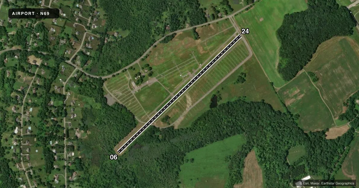
Runways & pattern
Full pagePattern entry · RWY 06
LEFT TRAFFICRunway end performance
| End | TORA | TODA | ASDA | LDA | VGSI | Approach lights | Obstruction |
|---|---|---|---|---|---|---|---|
| 06 | — | — | — | — | — | — | 45', trees, 230' from thr, 41' R of cntrln, slope 0 |
Declared distances in feet. TORA = takeoff run available, TODA = takeoff distance, ASDA = accelerate-stop, LDA = landing distance.
Airport sketch
Runways drawn to scale from FAA survey coordinates, rendered over satellite imagery. Not for navigation.
Approaches & charts
Services on the field
Fuel grades, oxygen, maintenance, ramp storage and lighting — as declared to the FAA by the airport operator.
Fuel & services
- Fuel
- Not available
- Oxygen (bottled)
- Not available
- Oxygen (bulk)
- Not available
- Airframe repair
- Not available
- Power plant repair
- Not available
Ramp & ground
- Transient storage
- Tie-down
- Landing fee
- No fee published
- Customs
- Not available
- Wind indicator
- Yes
- Segmented circle
- No
Fuel & FBOs
Cheapest 100LL and Jet A on the field and nearby. Always confirm with the FBO before taxi.
Airport notes
Surface conditions, obstructions, local procedures, lighting outages and other notes published with each FAA cycle.
General notes
- GEESE ON & INVOF RWY.
- FOR CD CTC NEW YORK APCH AT 516-683-2448.
Runway surface & condition
- 06/24NOT PLOWED. FLEA MARKET OBSTNS & MATERIAL ON RWY.
Approach & departure obstructions
- 0665 FT TREES AT RWY END, 30-105 FT RIGHT AND 60-129 FT LEFT. VARIOUS MATERIALS MAY BE NEXT TO RWY ENDS AFTER FLEA MARKETS.
- 24+10 FT GRVL RDS 25 FT FM THR; 3 FT BERM PARELLEL TO 3RD ROAD 75 FT FM THR.
Other notes
- 06/24WIDE CRACKS & WEEDS ON RWY. NOT PASSABLE.
- 06/24WIDE CRACKS & WEEDS ON RWY. NOT PASSABLE.
VFR map & nearby airports
VFR sectional. Tap any ICAO chip to open that airport.
Key facts · N69
Answer card- ICAO
- N69
- Name
- STORMVILLE
- Location
- STORMVILLE, NEW YORK
- Elevation
- 358 ft MSL
- Traffic pattern altitude
- 1,358 ft MSL (1,000 AGL)
- Control tower
- Non-towered (use CTAF)
- Total runways
- 1
- Longest runway
- 06/24 · 3,315 ft
- Published ILS approaches
- 0
- Published frequencies
- 4
- Magnetic variation
- 12°
- Current flight rules
- VFR
- Current wind
- 000° at 0 kt
- Favored runway now
- –
Stormville Airport (N69) sits in Stormville, New York. Field elevation is 358 ft MSL. It has one runway, 06/24, with a length of 3,315 ft. The runway is asphalt. Published remarks say runway 06/24 has wide cracks and weeds, so it is not passable. The same remarks also note flea market material on the runway, geese in and near the runway and obstacles near both ends. Treat this field as unusable unless the current FAA Chart Supplement and the airport operator confirm a change in status.
There is no control tower. CTAF and UNICOM are both 122.8. New York Approach and Departure are listed on 132.75 and 363.1. No ILS approaches are published. Pattern altitude is not published, so use 1,000 ft AGL for light piston operations unless current published guidance says otherwise. That puts the standard pattern at 1,358 ft MSL based on the field elevation.
No on-field FBOs are listed. For clearance delivery, the published remark directs pilots to New York Approach at 516-683-2448. If you are planning a stop here, verify runway condition and field access before launch. The runway status and the obstruction notes make this a place where current information matters more than the chart alone.